
Ice Navigation in Canadian Waters
Chapter 1: Icebreaking and Shipping Support Services
Table of Contents
- Preface
- Chapter 1: Icebreaking and Shipping Support Services
- Chapter 2: Regulations and Guidelines
- Chapter 3: Ice Climatology and Environmental Conditions
- Chapter 4: Navigation In Ice Covered Waters
- Chapter 5: Vessel Design and Construction for Ice Operations
- Annex I: Terminology for Ice, Navigation and Vessel Design
- Annex II: Reference Material
Chapter 1: Icebreaking and Shipping Support Services
1.1 General
There are a variety of icebreaking and support services available to vessels transiting Canadian ice-covered waters. CCG Ice Operations centres are in operation seasonally as ice conditions dictate. These centres work in conjunction with Marine Communications and Traffic Services (MCTS) centres to provide up-to-date ice information, to suggest routes for vessels to follow through or around ice, and to co-ordinate icebreaker assistance to shipping.
Ice Operations centres are in contact with icebreakers at all times and monitor progress of shipping within their area of responsibility. In addition, CIS has fully qualified Ice Service Specialists with air ice reconnaissance capacity who are involved with Ice Operations centres on a full-time basis throughout the ice navigation season. The regional Coast Guard icebreaking superintendents have a complete and current picture of the prevailing ice conditions in their area and the anticipated trend of conditions and are therefore well equipped to provide reasoned advice on the best routes to pursue.
To obtain the maximum benefit from the service, it is essential that mariners report to the CCG before their vessels enter waters where ice may be encountered. These initial reports and subsequent position reports from vessels will ensure a continuing watch on the ship's progress by the CCG Ice Operations centres and, in the event icebreaker support becomes necessary, this can be provided with a minimum of delay. There are a limited number of icebreakers available to support shipping. Mariners are encouraged to follow the recommended route with which they are provided. They may also assist and support this service by providing reports on the ice they encounter, either in plain language or in the simple code contained in section 4.16.3.
1.2 Communications
Communications play a key role in successful ice navigation. The mariner relies upon the receipt of accurate ice information and advice upon which decisions can be based for their future course and progress. Effective icebreaker support and assistance to shipping also requires reliable communications. Detailed information on communications with CCG icebreakers is provided in section 4.6.1 of this manual.
The Eastern Canada Vessel Traffic Services, known as ECAREG CANADA, and the Northern Canada Vessel Traffic Services, known as NORDREG CANADA are mandatory vessel traffic services. These systems also provide the mariner with information pertaining to ice conditions, vessel routing, icebreaker assistance and other CCG services. Vessels may contact ECAREG or NORDREG CANADA via the nearest MCTS centre or refer to the latest edition of the annual publication Radio Aids to Marine Navigation (RAMN).
Note: Contact must be made with ECAREG or NORDREG CANADA 24 hours before entering Canadian waters, to obtain a clearance. To meet Transport Canada Marine Safety and Security requirements (Pre-Arrival Information Report). Contact must also be provided to ECAREG or NORDREG CANADA 96 hours before entering Canadian waters as per section 4.29 of the RAMN.
MCTS centres accept messages without charge, such as:
- messages pertaining to weather or ice conditions and forecasts
- messages concerning aids to navigation
- ECAREG and NORDREG messages
- messages reporting pollution
- radio-medical messages
For additional information on MCTS message services, consult the latest edition of the annual publication RAMN.
Note: In order to keep a current and accurate picture of the ice conditions it is highly recommended that vessels participating in the ECAREG or NORDREG provide position, ice and weather information at 1200, 1600 and 2000 UTC, when ice is present.
1.3 Canadian Coast Guard Ice Operations Centres
The CCG maintains Ice Operations centres to service regions where vessel operations are conducted in sea-ice conditions. Contact with all Ice Operations centres can be made through ECAREG CANADA and NORDREG CANADA (for Arctic waters) or through any MCTS Centre. Any requests from vessels for ice information, routing advice and icebreaker support that are received by ECAREG CANADA and NORDREG CANADA are passed to CCG ice superintendents.
Atlantic coast (Operating December to May)
Phone:
- For Icebreaking operations
- (709) 772-2078
- 1-800-565-1633 (option 7)
- For ice conditions
- (709) 772-2078
- 1-800-565-1633 (option 7)
Email:
- For general inquiries
- For 24-hour assistance
- For ice conditions
Fax:
- (709) 772-6640
Mail:
St. John Ice Centre
Canadian Coast Guard
PO Box 5667
St. John's NL A1C 5X1
Great Lakes and the Arctic (Great Lakes operating December to May. Arctic operating June to November)
Phone:
- For Icebreaking operations
- (514) 283-2784
- For ice conditions
- (514) 283-1752
- (514) 283-2069
Email:
- For Icebreaking operations
- For 24-hour assistance
- S.O.
- For ice conditions
Fax:
- (514) 283-1818
Mail:
Montréal Ice Centre
Canadian Coast Guard
5th floor, 105 McGill
Montréal QC H2Y 2E7
St. Lawrence (Operating December to May)
Phone:
- For Icebreaking operations
- (514) 283-1746
- For ice conditions
- (514) 283-1752
- (514) 283-2069
Email:
- For Icebreaking operations
- For 24-hour assistance
- N/A
- For ice conditions
Fax:
- (514) 283-1818
The CCG Ice Operations Centre operates in concert with the United States Coast Guard Ice Navigation Centres. Together they co-ordinate ice operations in the Great Lakes from upper Beauharnois Lock to Thunder Bay, including the main connecting navigable waterways, Georgian Bay, and the upper St. Lawrence River. The icebreaking season normally commences operation in December, as soon as temperature lowers and ice starts to form and terminates when ice conditions permit unrestricted navigation. Vessels operating in this zone may obtain the latest ice information by contacting the Ice Operations Centre via any CCG MCTS Centre.
One purpose of the Ice Operations centres is to maintain a current picture of ice conditions, acquired from information supplied by the CIS, as well as from vessel and shore ice reports, and ice reconnaissance flights. This update is available on request 24 hours a day through MCTS centres. The Ice Operations centres also plan daily activities and tasks for icebreakers stationed in their area. These daily plans are based on the ice conditions and requests for icebreaker support. These plans, as well as weather and ice conditions and forecast, are provided daily through a daily conference call with the industry and CCG partners, and a Power Point presentation is available through e-Navigation Portal.
The Ice Operations officers, supported by the Ice Service Specialists (ISS), prepare detailed recommended ice routes for vessels, which are updated on a daily basis or as required. All routing is provided in terms of waypoints and may also be available overlaid on an Ice Chart. Recommended ice routes for the main shipping lane through the Gulf of St. Lawrence and other ice information may be obtained from the CCG e-Navigation Portal. Figure 1 is an example of a recommended route.
The CCG has established levels of service (LOS) for Icebreaking Operations. The LOS provides a description of the various services as well as service standard targets, such as the availability of icebreakers (where and when) and how long it may take an icebreaker to arrive on scene to provide assistance.
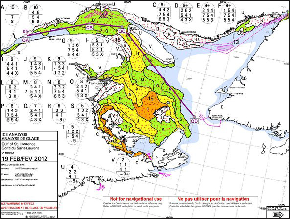
Figure 1 - Example of a Recommended Ice Route in the Gulf of St. Lawrence
Text version: Example of a Recommended Ice Route in the Gulf of St. Lawrence
From Canadian Ice Service, an ice chart providing a general view of the Gulf of St. Lawrence and its surroundings.
A title box provide details on that product: Ice Analysis, Gulf of St. Lawrence, at 1800 zulu time, on 19 February 2012, data based on MODIS satellite imagery and an ice warning in effect which can occur depending on weather.
Multiple egg codes describe ice conditions in details: the ice concentration, stage of development and floe size. Each ice egg is lettered and associated with polygons drawn on the map with that respective letter.
A recommended ice route is plotted on that daily product to advise navigators on the best route to follow instead of common official shipping corridors. That route follows the purple line joining waypoints QD, QC, QB and QA.
Also, as for most ice other types of ice charts, this product also can provide vectors overlayed on the polygons to identify anticipated ice drifts in nautical miles per day as the legend suggests in the right bottom corner of the map. On the map, below waypoint QC in Honguedo Strait we notice such a vector describing an expected drift of 16 nautical miles for the next 24 hours which is equivalent to 0.67 knots (nm per hr).
1.4 Winter Navigation in Southern Canada
1.4.1 Reporting Requirements
The Eastern Canada Vessel Traffic Service System, known as ECAREG CANADA, is a mandatory vessel traffic services system providing the mariner with a single contact for Coast Guard services. The Eastern Canada Vessel Traffic Services Zone Regulations apply to every vessel of 500 gross register tonnage (GRT) or more. They are also mandatory for vessels engaged in towing or pushing one or more vessels with combined tonnage of 500 GRT, or when either vessel is carrying a pollutant or dangerous goods, as defined in Transportation of Dangerous Goods Act, 1992.
The Eastern Canada Traffic Zone comprises all Canadian East Coast Waters south of Cape Chidley (60°00'N), the Gulf of St. Lawrence and the St. Lawrence River east of 66°00'W. Local vessel traffic service zones are excluded from the ECAREG CANADA Zone but will forward any requests for ice services to ECAREG CANADA and/or the Ice Operations Centre.
Vessels transiting the St. Lawrence River west of longitude 66°W may obtain ice information for the St. Lawrence River by contacting ECAREG CANADA via a MCTS centre prior to crossing 66°W, or a MCTS Centre on the appropriate vessel traffic service’s frequency if transit of the St. Lawrence River has commenced.
Inbound vessels making their initial clearance request to ECAREG CANADA should include the following information in addition to that required by the Eastern Canada Traffic Zone Regulations:
- draft, forward and aft
- displacement tonnage
- open water speed
- ice class, if applicable, and classification society
- number of propellers
- shaft horsepower
- type of propulsion system
A clearance issued by ECAREG CANADA authorizes a vessel to proceed subject to any conditions issued in the clearance. Routine reports are required when arriving at and departing a berth and exiting the ECAREG CANADA zone.
For details on the reporting requirements and information on the various services, refer to the latest edition of the annual publication RAMN.
Vessels that have reported to ECAREG CANADA, as per reporting requirements, and are approaching the Gulf of St. Lawrence by either Belle Isle Strait or Cabot Strait will receive ice routing 24 hours prior to entering the Gulf of St. Lawrence via MCTS Halifax. Additional routing for transit areas within the Gulf and in the river West of 66°W are handled by MCTS Les Escoumins.
1.4.2 Outside Gulf
- ECAREG CANADA
- MCTS centre: Halifax, Nova Scotia
- Call Sign: VCS
- Telephone: (902) 426-4956
- Fax: (902) 426-4483
- E-mail: hlxecareg1@innav.gc.ca
1.4.3 Inside Gulf and St. Lawrence River
- ECAREG CANADA
- MCTS centre: Les Escoumins, Quebec
- Call Sign: VCF
- Telephone: (418) 233-3483
- Fax: (418) 233-3299
- E-mail: ecareg.escoumins@innav.gc.ca
1.4.4 Iceberg limit information
- MCTS centre: Labrador, NL (located in Goose Bay, NL)
- Call Sign: VOK
- Telephone: (709) 896-2252
- Fax: (709) 896-8455
- E-mail: labrador.mcts@dfo-mpo.gc.ca and safety.labrador@innav.gc.ca
1.4.5 St. Lawrence Seaway
The St. Lawrence Seaway extends from Montreal to Lake Erie. It includes the Welland Canal, often referred to as the Western Section, and in the east, the Montreal - Lake Ontario section, which extends from the St. Lambert Lock at Montreal (the up bound entrance of the Seaway), to Iroquois Lock and beyond to Lake Ontario.
The navigation season on the waterway extends from mid March to late December. The St. Lawrence Seaway issues Seaway Notices to advise mariners of exact opening and closing dates of the navigation season and restrictions such as speed and draft and procedures for transiting the Seaway during the opening and closing. Seaway Authorities may increase or decrease the restrictions as ice and other conditions dictate. These changes will be announced as early as is practical, but in no case later than 24 hours before they go into effect. Mariners should consult the complete Regulations and Laws of the Great Lakes St. Lawrence Seaway System.
1.4.6 Great Lakes
The Great Lakes includes Lake Ontario, Erie, Huron, Michigan and Superior, as well the Georgian Bay. Detroit River connects from Lake Erie to Ste Clair River through the Lake Ste Clair. The Georgian Bay and Lake Huron are connected to Lake Superior through the North Channel, the St. Marys River and the Soo Locks extending to Whitefish Bay.
The navigation season extends from late March to late December. Close partnership exists between CCG and USCG for the services delivery of those sectors.
1.5 Arctic Waters including Hudson Bay and Hudson Strait
1.5.1 Reporting requirements
There are several Canadian authorities involved in marine shipping in the Canadian Arctic, namely, the federal government, the Government of the Northwest Territories (Yellowknife), the Government of Nunavut (Iqaluit), the Government of Yukon (Whitehorse) and the Canadian provinces of Manitoba and Québec. Vessels must contact the following relevant government organizations prior to an Arctic voyage:
- Transport Canada, Prairie and Northern Region - Marine will have all the up-to-date information relating to marine regulations applicable to vessels operating in the region and is responsible for all vessel approval. The vessel should have a general vessel itinerary that determines whether it falls within legal entry limits for the various Shipping Safety Control Zones.
- The CCG, Arctic Region should be provided with an itinerary early in the planning process. The CCG will use this information in combination with other submissions in the spring to plan the deployment of their icebreaking resources for the upcoming season.
- Customs and immigration regulations need to be contacted by any cruise vessel operators as the issuing of a coasting trade licence is necessary for vessels carrying passengers from one port to another in Canada. The Canada Border Services Agency coordinates this activity with Transport Canada. Organizers are also requested to provide details of their planned itineraries to the Department of Foreign Affairs and International Trade.
- After obtaining approval and arranging matters with the Canada Border Services Agency and Immigration, Refugees and Citizenship Canada, Transport Canada Security should be contacted to discuss security matters relating to the Marine Transportation Security Act.
1.5.2 Northern Canada Vessel Traffic Services Zone Regulations
The Northern Canada Vessel Traffic Services Zone Regulations apply to every vessel of 300 GRT or more; to vessels engaged in towing or pushing another vessel if the combined tonnage of 500 GRT or more; to vessel that are carrying as cargo, a pollutant or dangerous goods or towing or pushing a vessel that is carrying pollutant or dangerous goods.
NORDREG CANADA is a mandatory vessel traffic services system that also provides the mariner with information pertaining to ice conditions, vessel routing, icebreaker assistance and other government services. Mariners may obtain ice information and access shipping support services by sending a free message to NORDREG CANADA.
The Northern Canada Vessel Traffic Services (NORDREG) Zone (figure 2) consists of:
- the shipping safety control zones prescribed by the Shipping Safety Control Zones Order
- the waters of Ungava Bay, Hudson Bay and Kugmallit Bay that are not in a shipping safety control zone
- the waters of James Bay
- the waters of the Koksoak River from Ungava Bay to Kuujjuaq
- the waters of Feuilles Bay from Ungava Bay to Tasiujaq
- the waters of Chesterfield Inlet that are not within a shipping safety control zone, and the waters of Baker Lake
- the waters of the Moose River from James Bay to Moosonee
The NORDREG CANADA office is located in the MCTS centre in Iqaluit, Baffin Island, Nunavut and is supported by a CCG Ice Operations Centre. MCTS Iqaluit is seasonally operational from mid-May to late December each year. The actual dates are advertised by NAVWARN and NAVAREA Warnings. Outside of MCTS Iqaluit’s operational season, MCTS Prescott assumes the responsibility for NORDREG CANADA on behalf of the MCTS Iqaluit.
For NORDREG CANADA reporting requirements and information of various services, refer to the latest edition of the national publication RAMN.
Address
- NORDREG CANADA
- MCTS Centre: Iqaluit, Nunavut
- Call Sign: VFF
Operational: Approximately mid-May to late December:
- Email: IQANORDREG@innav.gc.ca
- Telex (telefax): 063-15529
- Telegraphic address: NORDREG CDA
- Telephone: (867) 979-5724/5269
- Fax: (867) 979-4264
From late December to mid-May:
- MCTS Centre: Prescott, Ontario
- Call Sign: VBR
- Telephone: 613-925-4471
- Fax: 613-925-451
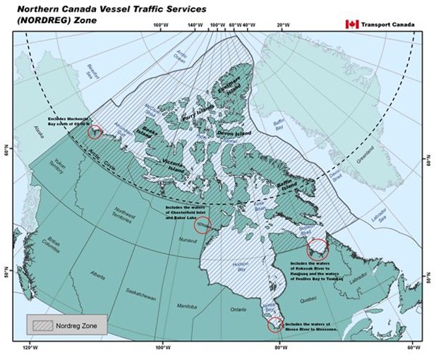
Figure 2 - Northern Canada Vessel Traffic Services Zone
Text version: Northern Canada Vessel Traffic Services Zone
From Transport Canada, a broad map identifying the Northern Canada Vessel Traffic Services (NORDREG) Zone pictured with a hatched drawing. It covers all Canadian Arctic archipelago waters. Also, is includes Hudson Bay, James Bay and Ungava Bay located South of latitude 60 degrees North because it is only accessible from Hudson Strait.
Furthermore, four red circles focus and highlight a few more affluent rivers and bays, per example Baker Lake area, that are all included in the NORDREG Zone system.
In darker shade added with dark line picture all Canadian territory and exclusive economic zone waters' limits.
1.6 Canadian Ice Service - Environment and Climate Change Canada
Throughout the year, ice information services for Canadian navigable waters are provided by CIS. The CIS maintains a central operating facility in Ottawa for assimilating all ice data and is responsible for satellite image analysis, ice charts and ice forecasts and warnings for Canada’s navigable waters.
Latest ice conditions and ice charts are issued daily for areas of known marine activity and where ice is a navigational hazard. They are distributed to the CCG Ice Operations centres and are also broadcast by radio and radio facsimile via MCTS centres. Particulars of these broadcasts are contained in the CCG publication RAMN, Part 2. The MCTS centres will also provide ice information on request, including pre-departure ice information. Information for longer term planning, extended period ice forecasts, and ice consultation services are available directly from the CIS, Ottawa or by consulting the Environment and Climate Change Canada (ECCC) Ice forecasts and observations. Ice information may also be obtained from the Ice Conditions section of the CCG e-Navigation Portal.
CIS website
Address
Canadian Ice Service
719 Heron Road, Annex E
Sir Leonard Tilley
Ottawa, Ontario
K1A 0H3
- Telephone: 1-877-789-7733
- Fax: (613) 947-9160
When required by the CCG, the CIS assigns ISSs’ on the larger CCG icebreakers. The ISS are responsible for receiving and interpreting satellite imagery and carrying out tactical ice reconnaissance on helicopters for the icebreaker and Ice Operations centres.
1.7 ECCC Storm Prediction Centres
Marine weather forecasts and warnings are issued for Canadian marine areas by ECCC from several regional Storm Prediction Centres (SPC). Meteorologists at these Centres provide 24-hour services in the form of forecasts and consultation. SPCs providing forecasts and warnings are:
- Prairie and Arctic SPC, for inland waters (Mackenzie River, Great Slave Lake and Lake Athabasca) and all Arctic waters including Beaufort Sea to St. Roch Basin, Baffin Bay, Hudson Bay, Foxe Basin, Hudson Strait, Davis Strait, and high Arctic waters along the western Queen Elizabeth Islands. Additional marine forecasts also provided for Lake Winnipeg, Lake Manitoba and Lake Winnipegosis.
- Ontario SPC, for several major inland lakes and waterways, the Canadian portion of the Great Lakes and the Ontario portion of the St. Lawrence River.
- Québec SPC, for the St. Lawrence River and Saguenay River.
- Atlantic SPC, for the Gulf of St. Lawrence and waters off Nova Scotia, New Brunswick, and Prince Edward Island.
- Newfoundland and Labrador SPC, for Newfoundland waters and Labrador Sea.
Environmental science centres across Canada can be found at Canada.ca - Environmental science centres across Canada.
Note: Information on marine weather including contact information can be found on the Weather Information of ECCC.
1.7.1 Weather forecasts for marine areas
Marine forecasts are generally prepared for distinct marine areas four times daily. The forecasts are valid for 2 days with a 3rd day outlook and provide information about wind, visibility, freezing spray, and temperature. A marine synopsis (or summary) is given with the forecast, including the movement of weather systems and warnings in effect. Special marine bulletins are issued when certain weather criteria are met. These are broadcast by MCTS centres according to schedules as published in the latest edition of the annual publication RAMN, Part 2.
For example, most of the SPCs provide 4 scheduled forecasts each day for their area of responsibility. The SPC located in Edmonton, AB provides twice daily scheduled forecasts for the Arctic and Hudson Bay waters.
1.7.2 Weather charts for marine areas
Weather information is also transmitted in facsimile chart form over high and low radio frequencies. Products include an analysis chart of existing weather conditions as well as prognosis charts. Mariners should consult the latest edition of the annual publication RAMN, part 5for details of ECCC’s programs, including the list of charts and their transmission times.
The Prairie and Arctic SPC provides weather charts for Arctic areas for broadcast by MCTS Iqaluit and repeater stations during the active shipping season. Numerous charts are transmitted by the Canadian Meteorological and Oceanographic Society centre in Halifax, Nova Scotia, including sea condition charts, throughout the year.
1.8 METAREAS and NAVAREAS
The CCG has assumed the responsibility of NAVAREA coordination for NAVAREAs XVII and XVIII as part of the World Wide Navigational Warning Service (figure 3). The service was declared to be in “Full Operational Condition” as of June 1, 2011. Mariners should consult the annual edition of RAMNfor additional information.
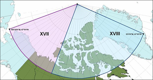
Figure 3 - METAREAS and NAVAREAS in the Canadian Arctic (photo courtesy of CCG)
Text version: METAREAS and NAVAREAS in the Canadian Arctic (photo courtesy of CCG)
A view of the geographical limits of the XVII (17) and XVIII (18) numbered NAVAREAs and METAREAs for the Canadian Arctic archipelago. The areas cover from the geographic North Pole down to latitude 67 degrees North. The XVII area is located between longitudes 168 degrees, 58 minutes West and 120 degrees West. The XVIII area is located between 120 degrees West and 35 degrees West. The information pertaining this figure is explained below.
During the navigation season meteorological warnings and forecasts for sections of METAREAS XVII and XVIII south of 75 degrees latitude will be broadcast via Inmarsat-C EGC SafetyNET:
| METAREA | Satellite Region | Broadcast (UTC) |
|---|---|---|
| XVII | (POR) | 0300, 1500 |
| XVIII | (AOR-W) | 0300, 1500 |
NAVAREA warnings for NAVAREAS XVII and XVIII south of 75 degrees latitude will be broadcast via Inmarsat-C EGC SafetyNET:
| NAVAREA | Satellite Region | Broadcast (UTC) |
|---|---|---|
| XVII | (POR) | 1130, 2330 |
| XVIII | (AOR-W) | 1100, 2300 |
In addition, during the navigation season meteorological warnings and forecasts and NAVAREA warnings for sections of NAVAREAS and METAREAS XVII and XVIII north of 70 degrees latitude will also be broadcast via high frequency narrow band direct printing (HF-NBDP):
| Frequency | MCTS Centre | Broadcast (UTC) |
|---|---|---|
| 8416.5 kHz | MCTS Iqaluit | 0330, 1530 |
1.9 NAVTEX service
Under GMDSS, the NAVTEX is part of the mandatory equipment carriage requirement for SOLAS vessels. In Canada, NAVTEX service is available from various transmitting sites using the frequency 518 kHz (English) and 490 kHz (French) for the broadcast of the navigational warnings, meteorological warnings, ice bulletins and forecasts, and Search and Rescue information. Additional information on the NAVTEX service is available in the latest edition of the annual publication RAMN.
1.9.1 Transmitting sites where NAVTEX service is available
| Controlled by | Site | Position | Range (NM) | ID 518 kHz (English) |
ID 490 kHz (French) |
|---|---|---|---|---|---|
| Placentia MCTS | Robin Hood Bay | 47º36.65’N 052º40.18’W |
300 | O | No data |
| Labrador MCTS | Cartwright | 53º42.52’N 057º01.35’W |
300 | X | No data |
| Sydney MCTS | Port Caledonia | 46º11.15’N 059º53.77’W |
300 | Q | J |
| Halifax MCTS | Chebogue | 43º44.65’N 066º07.32’W |
300 | U | V |
| Les Escoumins MCTS | Moisie | 50º11.75’N 066º06.74’W |
300 | C | D |
| Sarnia MCTS | Pass Lake | 48º33.80’N 088º39.37’W |
300 | P | No data |
| Prescott MCTS | Ferndale | 44º56.22’N 081º14.00’W |
300 | H | No data |
| Iqaluit MCTS | Iqaluit | 63º43.82’N 068º32.70’W |
300 | T | S |
| Prince Rupert MCTS | Amphitrite Point | 48º55.28’N 125º32.38’W |
300 | H | No data |
| Prince Rupert MCTS | Digby Island | 54º18.05’N 130º24.17’W |
300 | D | No data |
The above noted NAVTEX services are provided on a time-shared basis for the broadcast of the following subject indicator content:
- (A) Navigational Warnings
- (B) Meteorological Warnings
- (C) Ice Reports
- (D) Search and Rescue information / tsunami
- (E) Meteorological Forecasts
- (G) Automatic Identification System (AIS) service messages
- (J) GPS Messages
Broadcast time and content is shown in individual MCTS centre listings.
1.10 Winter aids to navigation in Canadian waters
During the winter months mariners are cautioned that most of the conventional buoys are lifted and are replaced in critical areas by unlit winter spar buoys: throughout the southwest and east coasts of Newfoundland, Cape Breton Island area, Gulf of St. Lawrence, and St. Lawrence River. It should be noted that there is a possibility that these winter spar buoys may be:
- under the ice
- off position
- of a dull or misleading colour, or
- missing from the charted position; thus, caution should be exercised accordingly when navigating in areas where they are used
Similarly, the charted or listed characteristics of these lights should not be relied upon. The current edition of Notices to Mariners should be consulted for details.
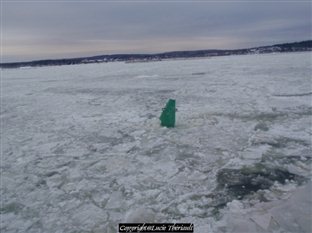
Figure 4 - Example of winter green buoy (photos courtesy of the CIS)
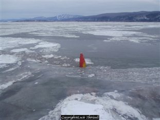
Figure 5 - Example of winter red buoy (photos courtesy of the CIS)
1.11 Icebreaking service fee
On December 21, 1998, commercial vessels became subject to the Icebreaking Services Fee (ISF). The ISF recovers a portion of the cost of providing Coast Guard ice route assistance, ice routing and information services, and marine facility and port maintenance services in support of commercial shipping. All commercial vessels arriving at or departing from Canadian ports located in the ice zone during the ice season are subject to a transit fee. Consult the Icebreaking services fees for details regarding their applications and explanations of the ice zone and ice season).
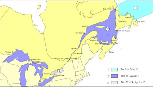
Figure 6 - Icebreaking Service Fee zones
Text version: Icebreaking Service Fee zones
A view of the Icebreaking service fee zones' limits combined with their service dates' range. CCG provides icebreaking service for and collects fees from the industry pertaining those zones:
- Zone 1 operating from January 15 to May 15 includes water on the North-East of Newfoundland to Strait of Belle Isle.
- Zone 2 operating from December 21 to April 15 includes the Gulf of St. Lawrence and St. Lawrence River up to Montreal. It also includes the Great Lakes excluding Lake Ontario.
- Zones 3 operating from December 21-24 to April 1-15 includes Welland Canal, Lake Ontario and the Seaway portion covering down to St. Lambert Locks in Montreal.
- Date modified: