
Ice Navigation in Canadian Waters
Chapter 2: Regulations and guidelines
Table of Contents
- Preface
- Chapter 1: Icebreaking and Shipping Support Services
- Chapter 2: Regulations and Guidelines
- Chapter 3: Ice Climatology and Environmental Conditions
- Chapter 4: Navigation In Ice Covered Waters
- Chapter 5: Vessel Design and Construction for Ice Operations
- Annex I: Terminology for Ice, Navigation and Vessel Design
- Annex II: Reference Material
2 Regulations and guidelines
2.1 General
The Canada Shipping Act, 2001 applies to all Canadian territorial waters and fishing zones. Arctic shipping in Canada is governed by several other pieces of legislation, such as the Arctic Waters Pollution Prevention Act and its regulations, the International Code for Vessels Operating in Polar Waters (the Polar Code, 2017), the Marine Liability Act, the Marine Transportation Security Act, the Coasting Trade Act the Canada Labour Code and the Marine Machinery Regulations. These acts and regulations were created to enhance safety and to protect life, health, property and the marine environment. It is the responsibility of vessel owners and operators to ensure that they comply with all applicable acts and regulations.
2.2 Marine Machinery Regulations
Under the Canada Shipping Act, 2001, the Marine Machinery Regulations, Schedule VII, Part I, Division IV Shipside Components states that for vessels required to operate in ice-covered waters where ice may choke sea-water inlets, maintenance of essential seawater supply must be maintained by:
- diversion arrangements for warmed cooling water from overboard discharges into sea- water inlet boxes
- means to clear sea-water inlet boxes, preferably by steam that has a pressure not in excess of the design working pressure of the sea-water inlet boxes and that is vented to the upper deck by means of a valved pipe, and
- ensuring sea-water inlet strainers have:
- perforations approximately 20 mm in diameter to prevent ingestion of large ice particles, and
- a strainer perforated area approximately 5 times the total cross-sectional area of the inlet pipes being served to ensure full fluid flow in slush ice conditions.
Warning: Ice conditions can be treacherous on the St. Lawrence River. Fresh water, currents, tide and water depth can push frazil ice down to depths of more than 10 metres and can plug seawater cooling inlets. This is an unusual occurrence and is rarely encountered in other parts of the world.
2.3 Supplementary publications
There is a vast amount of information concerning navigation in ice in this manual and within the Sailing Directions published by the Canadian Hydrographic Service. Other publications that are useful for the navigation officer, the Ice Navigator in the Arctic or the ship’s mariner are listed in Annex II, particularly Manual of Ice (MANICE).
Note: For a complete list of Transport Canada marine transportation acts and regulations, consult: Acts & Regulations.
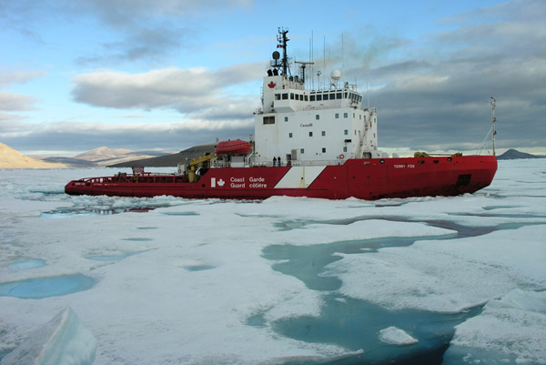
Figure 7 - Heavy icebreaker CCGS Terry Fox (photo courtesy of the CCG)
2.4 Regulations and guidelines for southern Canadian ice covered waters
2.4.1 Joint Industry - Government Guidelines for the Control of Oil Tankers and Bulk Chemical Carriers in Ice Control Zones of Eastern Canada TP 15163 B (2015)
Joint Industry – Government Guidelines for the Control of Oil Tankers and Bulk Chemical Carriers in Ice Control Zones of Eastern Canada - TP 15163 B (2015) (JIGs) apply to all laden oil tankers and to tankers carrying liquid chemicals in bulk when proceeding through an active Ice Control Zone in Eastern Canadian waters and fishing zones south of 60°north. The CCG may declare any ice control zone to be an active Ice Control Zone and promulgate this information via NAVWARN and Notices to Mariners. When proceeding through an active Ice Control Zone, all vessels to which the guidelines apply should, have on board at least one “Ice Advisor”, who meets the requirements as prescribed in JIGs. Figure 8 shows the Eastern Canada Ice Control Zones.

Figure 8 - Eastern Canada Ice Control ZonesFootnote 1
Text version: Eastern Canada Ice Control Zones
A map showing the limits of Transport Canada's Ice Control Zones within Canada's exclusive economic zone waters' limits. Broadly the zones are defined as follows:
- Zone T: From latitude 60 degrees North down to Strait of Belle Isle.
- Zone U: Belle Isle and Newfoundland surroundings from North to South is zone U.
- Zone V: Mostly the Gulf's core.
- Zone W: North East of the Gulf leading to Belle Isle.
- Zone X: Laurentian Channel, East of Cape Breton.
- Zone Y: South and South Eastern of Nova Scotia.
- Zone Z: Bay of Fundy.
- Zone V1: Northumberland Strait.
- Zone X1: Canso Causeway following 45 degrees North into the Laurentian Channel.
More details are available at Appendix A - Description of Ice Control Zones (canada.ca)
2.4.2 Guidelines for Navigation Under the Confederation Bridge (2009) – TP 13681E
Under Guidelines For Navigation Under The Confederation Bridge (2009) - TP 13681 E, vessels of over 1,500 GRT are required to utilize the central navigation channel, which is a compulsory pilotage zone pursuant to regulations made under the Pilotage Act. Traffic in the Northumberland Strait in the area of the Bridge is regulated by the Vessel Traffic Services Zones Regulations. When the Strait is declared an active ice zone and ice is present in the navigation channel the transiting vessel must be escorted by a suitably sized icebreaker.
2.4.3 Winter navigation on the River and the Gulf of St. Lawrence: practical notebook for marine engineers and deck workers TP 14335 Footnote 2
This publication is a complement to Ice Navigation in Canadian Waters and is intended for use by vessel owners, operators, charterers, agents and vessels’ officers who seek practical information on hazards which may be encountered when transiting eastern Canadian ice covered waters and in the St. Lawrence River. The publication provides advice for mariners who may be exposed to ice, freezing spray, slush ice and cold temperatures as well as the effects on machinery spaces, sea inlet boxes, deck equipment, lifesaving appliances, living quarters, the navigation bridge, cargo hold and ballast operations. This publication is available by consulting Winter navigation on the River and the Gulf of St. Lawrence: practical notebook for marine engineers and deck workers
2.4.4 Interim Standards for the Construction, Equipment & Operation of Passenger Ships in the Sea (1987) - TP 8941 E
Interim Standards for the Construction, Equipment & Operation of Passenger Ships in the Sea (1987) - TP 8941 E apply to all passenger vessels that are registered in Canada or engaged in the coasting trade of Canada when operating within a declared sea ice area within economic zones of eastern Canada.
2.5 Regulations and guidelines for the Canadian Arctic
Through the Arctic Waters Pollution Prevention Act, the Government of Canada through Marine Safety, a branch of Transport Canada enforces its responsibility for ensuring navigation in Arctic waters is conducted to preserve and protect the sensitive northern ecosystem. The regulations under this Act affect vessel navigation in the Arctic.
As well as the various international and Canadian regulations governing marine navigation, there are a number of regulations of specific interest to mariners which deal with shipping in the Canadian Arctic. The following are among the more important regulations:
- Arctic Shipping Safety and Pollution Prevention Regulations
- Arctic Waters Pollution Prevention Regulations
- Governor in Council Authority Delegation Order
- Shipping Safety Control Zones Order
- Steering Appliances and Equipment Regulations
Each of the regulations, standards or publications mentioned have been condensed to illustrate only the pertinent sections that may have the greatest impact on Arctic operations. Mariners are cautioned that this list of regulations is in no way exhaustive, and that the identified regulations are subject to ongoing amendments. Mariners are advised to familiarize themselves with all current Acts & Regulations governing areas of interest.
The Arctic Water Pollution Prevention Act and the Arctic Water Pollution Prevention Regulations provide measures to prevent pollution from vessels, and in particular, the deposit of waste into Arctic waters. The Arctic Shipping Safety and Pollution Prevention Regulations deal with construction and operational aspects of navigating in the Arctic, including the need for Ice Navigators. The regulations contains the Zone/Date System, which is a system dividing the Arctic into 16 Safety Control Zones, each with fixed opening and closing dates for vessels of various ice capabilities. The Arctic Ice Regime Shipping System (AIRSS) was introduced as a more flexible system that uses the actual ice conditions to determine whether entry is allowed in an ice regime. An Arctic Water Pollution Prevention Certificate may be issued to a vessel outside of Canada by the recognized International Association of Classification Societies (IACS).
2.5.1 Arctic Shipping Safety and Pollution Prevention Regulations
The Arctic Shipping Safety and Pollution Prevention Regulations govern safety and pollution prevention measures, in line with the Polar Code as of January 1st 2017.
The Arctic Shipping Safety and Pollution Prevention Regulationsintroduces the Zone / Date System in which the Arctic waters are divided into sixteen Shipping Safety Control Zones, with a schedule of earliest and latest entry dates for each zone corresponding to specific categories of vessels. Zone 1 has the most severe ice conditions and Zone 16 the least. Figure 9 is a map of the Canadian Arctic illustrating the sixteen Shipping Safety Control Zones. Tables 1 and 2 in the section below represent schedule 1 which identifies the permissive date for each class, as well as schedule 2 which identifies the international class equivalences.
2.5.2 Arctic Pollution Prevention Certificate
Shipowners may request an Arctic Water Pollution Prevention Certificate for vessels that carry more than 453 m3 of pollutants (including all oil, fuel, and lubricants).
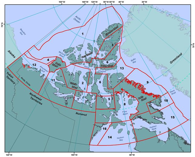
Figure 9 - Shipping Safety Control Zones (image courtesy of TC)
Text version: Shipping Safety Control Zones
A map showing the limits of Transport Canada's Shipping Safety Control Zones.
There are numbered from 1 to 15 covering up all Canadian Arctic Archipelago North of latitude 60 degrees North.
More details are available at both: The Zone/Date System (canada.ca) and TP 12259E - Arctic Ice Regime Shipping System (AIRSS) Standard (canada.ca).
Tableau 1 - Dates d'entrées dans les zones de contrôle de la sécurité de la navigationNote de bas de page 3
| Item | Col. 1: Category | Col. 2: Zone 1 | Col. 3: Zone 2 | Col. 4: Zone 3 | Col. 5: Zone 4 | Col. 6: Zone 5 | Col. 7: Zone 6 | Col. 8: Zone 7 | Col. 9: Zone 8 | Col. 10: Zone 9 | Col. 11: Zone 10 | Col. 12: Zone 11 | Col. 13: Zone 12 | Col. 14: Zone 13 | Col. 15: Zone 14 | Col. 16: Zone 15 | Col. 17: Zone 16 |
|---|---|---|---|---|---|---|---|---|---|---|---|---|---|---|---|---|---|
| 1 | Arctic Class 10, CAC 1 | All year | All year | All year | All year | All year | All year | All year | All year | All year | All year | All year | All year | All year | All year | All year | All year |
| 2 | Arctic Class 8, CAC 2 | Jul. 1 to Oct. 15. | All year | All year | All year | All year | All year | All year | All year | All year | All year | All year | All year | All year | All year | All year | All year |
| 3 | Arctic Class 7 | Aug. 1 to Sept. 30 | Aug. 1 to Nov. 30 | Jul. 1 to Dec. 31 | Jul. 1 to Dec. 15 | Jul. 1 to Dec. 15 | All year | All year | All year | All year | All year | All year | All year | All year | All year | All year | All year |
| 4 | Arctic Class 6, CAC 3 | Aug. 15 to Sept. 15 | Aug. 1 to Oct. 31 | Jul. 15 to Nov. 30 | Jul. 15 to Nov. 30 | Aug. 1 to Oct. 15 | Jul. 15 to Feb. 28 | Jul. 1 to Mar. 31 | Jul. 1 to Mar. 31 | All year | All year | Jul. 1 to Mar. 31. | All year | All year | All year | All year | All year |
| 5 | Arctic Class 4 | Aug. 15 to Sept. 15 | Aug. 15 to Oct. 15 | Jul. 15 to Oct. 31 | Jul. 15 to Nov. 15 | Aug. 15 to Sept. 30 | Jul. 20 to Dec. 31 | Jul. 15 to Jan. 15 | Jul. 15 to Jan. 15 | Jul. 10 to Mar. 31 | Jul. 10 to Feb. 28 | Jul. 5 to Jan. 15 | June 1 to Jan. 31 | June 1 to Feb. 15 | June 15 to Feb. 15 | June 15 to Mar. 15 | June 1 to Feb. 15 |
| 6 | Arctic Class 3, CAC 4 | Aug. 20 to Sept. 15 | Aug. 20 to Sept. 30 | Jul. 25 to Oct. 15 | Jul. 20 to Nov. 5 | Aug. 20 to Sept. 25 | Aug. 1 to Nov. 30 | Jul. 20 to Dec. 15 | Jul. 20 to Dec. 31 | Jul. 20 to Jan. 20 | Jul. 15 to Jan. 25 | Jul. 5 to Dec. 15 | June 10 to Dec. 31 | June 10 to Dec. 31 | June 20 to Jan. 10 | June 20 to Jan. 31 | June 5 to Jan. 10 |
| 7 | Arctic Class 2 | No Entry | No Entry | Aug. 15 to Sept. 30 | Aug. 1 to Oct. 31 | No Entry | Aug. 15 to Nov. 20 | Aug. 1 to Nov. 20 | Aug. 1 to Nov. 30 | Aug. 1 to Dec. 20 | Jul. 25 to Dec. 20 | Jul. 10 to Nov. 20 | June 15 to Dec. 5 | June 25 to Nov. 22 | June 25 to Dec. 10 | June 25 to Dec. 20 | June 10 to Dec. 10 |
| 8 | Arctic Class 1A | No Entry | No Entry | Aug. 20 to Sept. 15 | Aug. 20 to Sept. 30 | No Entry | Aug. 25 to Oct. 31 | Aug. 10 to Nov. 5 | Aug. 10 to Nov. 20 | Aug. 10 to Dec. 10 | Aug. 1 to Dec. 10 | Jul. 15 to Nov. 10 | Jul. 1 to Nov. 10 | Jul. 15 to Oct. 31 | Jul. 1 to Nov. 30 | Jul. 1 to Dec. 10 | June 20 to Nov. 30 |
| 9 | Arctic Class 1 | No Entry | No Entry | No Entry | No Entry | No Entry | Aug. 25 to Sept. 30 | Aug. 10 to Oct. 15 | Aug. 10 to Oct. 31 | Aug. 10 to Oct. 31 | Aug. 1 to Oct. 31 | 15 juil. au 20 oct. | Jul. 1 to Oct. 31 | Jul. 15 to Oct. 15 | Jul. 1 to Nov. 30 | Jul. 1 to Nov. 30 | June 20 to Nov. 15 |
| 10 | Type A | No Entry | No Entry | Aug. 20 to Sept. 10 | Aug. 20 to Sept. 20 | No Entry | Aug. 15 to Oct. 15 | Aug. 1 to Oct. 25 | Aug. 1 to Nov. 10 | Aug. 1 to Nov. 20 | Jul. 25 to Nov. 20 | Jul. 10 to Oct. 31 | June 15 to Nov. 10 | June 25 to Oct. 22 | June 25 to Nov. 30 | June 25 to Dec. 5 | June 20 to Nov. 20 |
| 11 | Type B | No Entry | No Entry | Aug. 20 to Sept. 5 | Aug. 20 to Sept. 15 | No Entry | Aug. 25 to Sept. 30 | Aug. 10 to Oct. 15 | Aug. 10 to Oct. 31 | Aug. 10 to Oct. 31 | Aug. 1 to Oct. 31 | Jul. 15 to Oct. 20 | Jul. 1 to Oct. 25 | Jul. 15 to Oct. 15 | Jul. 1 to Nov. 30. | Jul. 1 to Nov. 30 | June 20 to Nov. 10 |
| 12 | Type C | No Entry | No Entry | No Entry | No Entry | No Entry | Aug. 25 to Sept. 25 | Aug. 10 to Oct. 10 | Aug. 10 to Oct. 25 | Aug. 10 to Oct. 25 | Aug. 1 to Oct. 25 | Jul. 15 to Oct. 15 | Jul. 1 to Oct. 25 | Jul. 15 to Oct. 10 | Jul. 1 to Nov. 25 | Jul. 1 to Nov. 25 | June 25 to Nov. 10 |
| 13 | Type D | No Entry | No Entry | No Entry | No Entry | No Entry | No Entry | Aug. 10 to Oct. 5 | Aug. 15 to Oct. 20 | Aug. 15 to Oct. 20 | Aug. 5 to Oct. 20 | Jul. 15 to Oct. 10 | Jul. 1 to Oct. 20 | Jul. 30 to Sept. 30 | Jul. 10 to Nov. 10 | Jul. 5 to Nov. 10 | Jul. 1 to Oct. 31 |
| 14 | Type E | No Entry | No Entry | No Entry | No Entry | No Entry | No Entry | Aug. 10 to Sept. 30 | Aug. 20 to Oct. 20 | Aug. 20 to Oct. 15 | Aug. 10 to Oct. 20 | Jul. 15 to Sept. 30 | Jul. 1 to Oct. 20 | Aug. 15 to Sept. 20 | Jul. 20 to Oct. 31 | Jul. 20 to Nov. 5 | Jul. 1 to Oct. 31 |
Table 2 - Construction Standards for Types A, B, C, D and E VesselsNote de bas de page 4
| Item | Col. 1: Type of Vessel | Col. 2: American Bureau of Shipping (ABS) | Col. 3: Bureau Veritas (BV) | Col. 4: China Classification Society (CCS) | Col. 5: Nippon Kaiji Kyokai (ClassNK) | Col. 6: DNV-GL | Col. 7: Finnish-Swedish Ice Class Rules (FSICR) | Col. 8: International Association of Classification on Societies (IACS) | Col. 9: Korean Register of Shipping (KR) | Col. 10: Lloyd’s Register of Shipping (LR) | Col. 11: Poiski Rejestr Statkow (PRS) | Col. 12: Rina Services (RINA) | Col. 13: Russian Maritime Register of Shipping |
|---|---|---|---|---|---|---|---|---|---|---|---|---|---|
| 1 | Type A | Ice Class A0 | ICE CLASS IA SUPER | Ice Class B1* | NS (Class 1A Super Ice Strengthening) | Ice (1A*) or ICE-1A or E4 | 1A Super | PC1 to PC7 | IA Super | Ice Class 1AS FS (+) or Ice Class 1AS FS (+) | L1A | ICE CLASS 1A SUPER | UL or LU5 or Arc5 |
| 2 | Type B | Ice Class B0 | ICE CLASS IA | Ice Class B1 | NS (Class 1A Ice Strengthening) | Ice (1A) or ICE-1A or E3 | 1A | – n/a | 1A | Ice Class 1A FS (+) or Ice Class 1A FS | L1 | ICE CLASS 1A | L1 or LU4 or Arc4 |
| 3 | Type C | Ice Class C0 | ICE CLASS IB | Ice Class B2 | NS (Class 1B Ice Strengthening) | Ice (1B) or ICE-1B or E2 | 1B | – n/a | 1B | Ice Class 1B FS (+) or Ice Class 1B FS | L2 | ICE CLASS 1B | L2 or LU3 or Ice 3 |
| 4 | Type D | Ice Class D0 | ICE CLASS IC | Ice Class B3 | NS (Class 1C Ice Strengthening) | Ice (1C) or ICE-1C or E1 | 1C | – n/a | 1C | Ice Class 1C FS (+) or Ice Class 1C FS | L3 | ICE CLASS 1C | L3 or LU2 or Ice 2 |
| 5 | Type E | Ice Class E0 | 1D | Ice Class B | NS (Class 1D Ice Strengthening) | ICE-C or E | Category II | – n/a | 1D | Ice Class 1D or Ice Class 1E | L4 | 1D | L4 or LU1 or Ice 1 |
2.5.3 Guidelines for vessels operating in polar waters
Recognizing that certain hazards commonly found in Arctic and Antarctic waters are not adequately addressed by SOLAS and MARPOL, the IMO Guidelines for Ships Operating in Polar Waters (Polar Guidelines) aim to promote safety of navigation and to prevent pollution from vessel operations in polar waters. The Guidelines, when applied in their entirety, result in a holistic approach covering the design and outfitting of vessels for the conditions that they will encounter, their crewing by adequate numbers of suitably trained personnel, and their operation in a planned and prudent manner.
The Polar Guidelines take into account that the single most significant factor in polar operations is ice by recommending that only those vessels with a Polar Class designation or a comparable alternative standard of ice-strengthening appropriate to the anticipated ice conditions should operate in polar ice-covered waters. The Polar Guidelines provide guidance in structural design or machinery requirements through reference to a parallel set of Unified Requirements for Polar Class Ships developed by the International Association of Classification Societies (IACS).
The Polar Guidelines also address the fact that the polar environment imposes additional demands on vessel systems such as: navigation, communications, lifesaving, fire-fighting, etc. They emphasize the need to ensure that all vessel systems are capable of functioning effectively under anticipated operating conditions, notably the possibility of extreme cold. The Polar Guidelines stipulate that systems should provide adequate levels of safety in emergencies. In addition, The Polar Guidelines recognize that safe operation in polar conditions requires specific attention to human factors including training and operational procedures.
All vessels operating under the Polar Guidelines should carry on board a sufficient number of Ice Navigators to guide operations when ice is present. The Guidelines define an Ice Navigator as ”any individual who, in addition to being qualified under the Standards of Training, Certification and Watchkeeping for Seafarers (STCW) Convention, is specially trained and otherwise qualified to direct the movement of a vessel in ice-covered waters”.
2.5.4 Seafarers’ Training, Certification and Watchkeeping Code (STCW Code)
Guidance regarding training of mariners and officers for vessels operating in polar waters is contained in the Standards for Training, Certification and Watchkeeping (STCW) Code. IMO has developed an internationally recognized criteria for training and experience for ice navigators as part of the mandatory Polar Code. With respect to Canadian regulations, the specific qualifications of an Ice Navigator are stated in Section 26 of the Arctic Shipping Safety and Pollution Prevention Regulations (ASSPPR).
Section B-V/g* of the STCW Code provides guidance for training mariners and officers for vessels operating in polar waters. It is important that mariners, officers in charge of a navigational watch and officers in charge of an engineering watch on board vessels operating in polar waters should have relevant experience and training.
Prior to being assigned duties on board such vessels, mariners and officers in charge of a navigational watch should have basic knowledge on the following subjects 2 to 11. Officers in charge of an engineering watch should have a basic knowledge of subjects 3, 6, 10 and 11. Mariners and chief engineer officers should have sufficient and appropriate experience in operating vessels in polar waters.
- Ice characteristics – ice areas
- Ship’s performance in ice and cold climate
- Voyage and passage planning for a vessel in ice
- Operating and handling a vessel in ice (operations and navigation)
- Operating and handling a vessel in ice (propulsion, rudder and other engineering systems)
- Regulations and recommendations
- Equipment limitations
- Safety precautions and emergency procedures (availability and limitations of infrastructure)
- Safety precautions and emergency procedures (safe working procedures, common damages and limitations of fire-fighting)
- Environmental considerations.
2.5.5 Polar Classes
From an operational perspective, the safety of the vessel will remain the ultimate responsibility of the mariner, who will be provided, directly or indirectly with the expertise and information needed to make prudent navigational decisions.
Ice strengthening appropriate for the conditions encountered is fundamental to safe operation in ice. Ice classes to indicate capability in ice have been established by many organizations. Canada supports use of the Polar Classes set out in the IACS Unified Requirements for Polar Vessels (see in table 3 below). The class descriptions are deliberately general to suit a variety of operations and their relation vessels are set to provide a reasonably smooth gradation of capability and cost.
Table 3 - Polar Class descriptions
| Polar Class | General description |
|---|---|
| PC 1 | Year-round operation in all Polar waters |
| PC 2 | Year-round operation in moderate multi-year ice conditions |
| PC 3 | Year-round operation in second-year ice which may include multi-year ice inclusions |
| PC 4 | Year-round operation in thick first-year ice which may include old ice inclusions |
| PC 5 | Year-round operation in medium first-year ice which may include old ice inclusions |
| PC 6 | Summer/autumn operation in medium first-year ice which may include old ice inclusions |
| PC 7 | Summer/autumn operation in thin first-year ice which may include old ice inclusions |
Certain Polar Classes are based on existing classes for which good performance data exists. The others have been interpolated between or extrapolated from the others. The lowest classes, PC 6 and PC 7, can be considered as ‘polarized’ versions of the top two Baltic classes and the top classes represent levels of capability that have not yet been provided by commercial cargo-carrying vessels.
2.5.6 Arctic Ice Regime Shipping System
Referenced in the Arctic Shipping Safety and Pollution Prevention Regulations, AIRSS standards have been developed to enhance the safety and efficiency of shipping operations in the Canadian Arctic. The standards have been developed characterize the relative risk which different ice conditions pose to the structure of different vessels.
The Zone/Date System is based on rigid controls. The AIRSS emphasizes the responsibility of the mariner for the safety of the ship. This provides a more flexible framework to assist in decision-making. Both systems are presently working in parallel, allowing operators to navigate outside the Zone/Date limits when ice conditions permit. Operators will continue to be able to use the Zone/Date scheme to generally plan voyages to the Arctic while being encouraged to avoid dangerous ice conditions through the use of the AIRSS. The application of the AIRSS will require an Ice Navigator and the use of all available ice information.
The AIRSS Standards are based on the concept that ice conditions can be quantified through a simple ice numeral (IN) calculation which indicates whether or not a given set of ice conditions (regimes) will be safe for a particular vessel. A wide range of ice navigation parameters including visibility, vessel speed, manoeuvrability, the availability of an icebreaker escort and the knowledge and experience of the crew must also be considered when applying the Ice Regime System.
The AIRSS can only be used under the following circumstances:
- If the vessel has a set of ice multipliers (IM). For Canadian Arctic Category (CAC) or Type vessels, their IMs are listed in the IM table. For all other vessels, IMs are assigned on a case-by-case basis supported by the assessed ice strength of the vessel. For information on application of AIRSS in relation to Polar Class vessels, refer to Ship Safety Bulletin 04/2009 IACS Unified Requirements for Polar Class Vessels - Application in Canadian Arctic Waters.
- If an Ice Regime Routing Message is sent to NORDREG CANADA.
- If the ice numerals calculated for the vessel are zero or positive for all of the ice regimes that are along the intended route.
- The vessel must have an Ice Navigator on board. The specific qualifications of an Ice Navigator are stated in Section 26 of the ASSPPR.
There are several steps to follow in order to apply the AIRSS.
- Obtain the most current ice information for the planned passage and select a desired route.
- Determine the various ice regimes along the route and calculate the INs for your vessel in each regime.
The ice charts from the CIS are well suited to AIRSS and, based on their scale, they could be used directly to define ice regimes for voyage planning, strategic planning and to a limited extent, tactical navigation. Other forms of information, including satellite imagery, may require more interpretation by an Ice Navigator. - If all the INs are zero or greater, you must advise NORDREG CANADA, through the submission of an Ice Regime Routing Message.
This message does not constitute a request for permission to proceed; rather it is made for the information of the CCG Icebreaking Superintendent via NORDREG CANADA. Based on this information, the Transport Canada duty officer issue acknowledgement via NORDREG CANADA for the vessel to proceed along the projected route. This represents an acknowledgement that the planned route appears appropriate - it does not relieve Masters of their responsibility to navigate with due caution and with continuous, careful attention to the local ice conditions. - If the IN for any ice regime is negative, consider the alternatives, such as selecting another route, waiting for improved in ice conditions or requesting the assistance of an icebreaker. When an icebreaker or other vessel modifies a regime, or there is a change in the ice conditions, giving positive INs, you may proceed after advising NORDREG CANADA with the updated information.
- Within 30 days of completing the voyage, you must send an After Action Report to Transport Canada.
Additional information is provided in section 2.5.8.
2.5.6.1 Ice Regime Routing Message
Every message required by subsection 9(1) of the Arctic Shipping Safety and Pollution Prevention Regulations must contain all designators listed in table 4. The update message required by subsection 9(2) of the Arctic Shipping Safety and Pollution Prevention Regulationsmust include designators A to K. Every message must be addressed to Transport Canada and be provided to one of the MCTS centres that is designated by the CCG to receive NORDREG CANADA reports. The intended route describe by designator G of table 4 may include more than one Shipping Safety Control Zone.
Tableau 4 - Gabarit de message de routage en régimes de glaces
| Item | Designator | Subject | Information |
|---|---|---|---|
| 1 | A | Vessel | The vessel’s name and the name of the state whose flag the vessel is entitled to fly. |
| 2 | B | Call Sign and IMO number | The vessel’s call sign and International Maritime Organization (IMO) ship identification number. |
| 3 | C | Vessel Ice Class | The Ice Class that corresponds to the Ice Class indicated on the Polar Ship Certificate. For vessels with no Polar Ship Certificate, it must correspond to the Ice Class indicated on the vessel Classification Society Certificate. |
| 4 | D | Date & UTC time | A 6-digit group followed by a Z, the first 2 digits giving the day of the month, the next 2 digits giving the hour, and the last 2 digits giving the minutes. |
| 5 | E | Final destination | The name of the final destination. |
| 6 | F | Position, course & speed | A 4-digit group giving the latitude in degrees and minutes suffixed with N, and a 5-digit group giving the longitude in degrees and minutes suffixed with W. The true course. A 3-digit group. The speed in knots. A 2-digit group. |
| 7 | G | Intended route | A series of 4-digit groups giving the latitude in degrees and minutes suffixed with N, and 5-digit groups giving the longitude in degrees and minutes suffixed with W to describe the planned route. |
| 8 | H | Ice Regime(s) to be encountered | For each regime along the planned route, a series of ice concentration in tenths (C), the corresponding ice type (IT) using the ice type symbol or the egg code, followed by the letter IN for AIRSS message or Risk Index Outcome (RIO) for POLARIS message and the resulting IN or RIO: AIRSS C1, IT1, C2, IT2, …, CTn, ITn, INxx POLARIS C1, IT1, C2, IT2, …, CTn, ITn, RIOxx |
| 9 | I | Source(s) of Ice Information | Indicate the source(s) used to determine the ice conditions, e.g. ice charts name/date, visual observations, reports from shore stations and from other vessels in the area, helicopter (or drone) reconnaissance, satellite radar imagery, or other means. |
| 10 | J | Other pertinent information or comments | Provide additional information that may have been considered or is pertinent to the assessment, such as limitations associated with the ice regime assessment, near regimes that are likely to drift into the proposed route, an alternate route that may be considered, or planned escorting needs. |
| 11 | K | Name of escorting vessel | Provide the name of the escorting vessel if the IN has been determined for the track of an escorting vessel. |
| 12 | L | Ice Navigator(s) and officers certified for vessels operating in polar waters | Name(s) and certification information of Ice Navigator(s) and officers certified in accordance with the STCW Convention requirements for vessels operating in polar waters. |
| 13 | M | Vessel master | Name of the aster and certification information in accordance with the STCW Convention requirement for vessels operating in polar waters. |
2.5.7 Ice Navigator Footnote 5
Vessels, other than a cargo vessel of 500 gross tonnage or more or a passenger vessel that are certified as meeting the requirements of Chapter I of SOLAS, that navigate in a shipping safety control zone set out in columns 2 to 17 of Schedule 1 during a period other than those set out in item 14 of that schedule must have an ice navigator on board.
2.5.7.1 Requirements
The ice navigator on a vessel must
- have all of the qualifications under the Canada Shipping Act, 2001 to act as a master or a person in charge of the deck watch; and
- either:
- have served on a vessel in the capacity of master or person in charge of the deck watch for at least 50 days, of which 30 days must have been served in international Arctic waters while the vessel was in ice conditions that required the vessel to be assisted by an ice-breaker or that required manoeuvres to avoid concentrations of ice that might have endangered the vessel, or
- hold a certificate in advanced training for ships operating in polar waters in accordance with regulation V/4 of the International Convention on Standards of Training, Certification and Watchkeeping for Seafarers.
2.5.8 Arctic Ice Regime Shipping System - Pictorial Guide - TP 14044 E
Transport Canada and the Canadian Hydraulics Centre, National Research Council of Canada published the Arctic Ice Regime Shipping System - Pictorial Guide as a reference guide for the AIRSS to help explain the system and to provide images which help determine ice characteristics such as concentration and stages of development.
Ice in the Arctic is a very complex and dynamic material. It has a wide range of thickness, concentration, age and roughness. Moreover, ice conditions continually change throughout the year. There are a number of vessels that travel in Canada's Arctic and it is important that their transit through ice is safe for both personnel safety as well as preventing pollution in the Arctic. There have been over 200 reported ice damage events over the past 25 years. Approximately one-third of those events had the potential to cause pollution. AIRSS is intended to minimize the risk of damage by taking into account the actual ice conditions through which vessels sail. Because different vessels have different capabilities in ice-covered waters, each vessel is assessed and assigned to a Vessel Class. This rating reflects the strength, displacement and power of the vessel. The relative risk of damage to a vessel by different types of ice is taken into account using “weighting” factors, called IMs. In the Ice Regime System, a simple calculation relates the strength of the vessel to the danger presented by different ice regimes. The calculation gives an IN. Ice regimes that are not likely to be hazardous have zero or “positive” INs. Those regimes that could be dangerous have “negative” INs. As always however, the safety of the vessel is the responsibility of the Mariner.
2.5.8.1 Characterizing the Ice Regime
AIRSS relies upon accurately assessing the ice conditions. The CIS issues ice charts to provide an overview of the latest ice conditions in different geographic regions. Ice charts are produced using the most current available technology and give an excellent indication of the general ice conditions in an area. As such, ice charts are one of the most useful resources to provide a vessel with an overview of the ice conditions in a certain area, in advance of when it is needed. That information can be used successfully for strategic planning and are very useful when the vessel is confronted with difficult ice conditions, to help determine alternate routes.
Although ice charts have an important role for vessels traversing ice-covered regions, their importance is no substitute for real-time observations made from the bridge. AIRSS relies upon up-to-date information that is obtained directly from the bridge and integrates that real-time information with the capability of each vessel class. This results in customized routing for each vessel, depending upon its ice-worthiness.
2.5.8.2 Ice Multiplier
One of the principal concepts behind the Ice Regime System is that every ice type including open water has a numerical value that is dependent on the ice category of the vessel. This number is called the ice multiplier (IM). The value of the IM reflects the level of risk or operational constraint that the particular ice type poses to each category of vessel. To find the applicable IM for your ship, refer to the IM table and highlight the appropriate vertical column based on your vessel category. This will comprise the IM for all the different ice types listed vertically on the left side of the table. If you do not know your vessel category refer to your Arctic Pollution Prevention Certificate or Schedule II of the Arctic Shipping Safety and Pollution Prevention Regulations.
Table 5 - IM table
| IMO Ice Codes | Ice Types | Thickness | Type E | Type D | Type C | Type B | Type A | CAC 4 | CAC 3 |
|---|---|---|---|---|---|---|---|---|---|
| 7• or 9• | Old/Multi-year ice (MY) | n/a | -4 | -4 | -4 | -4 | -4 | -3 | -1 |
| 8• | Second-year Ice (SY) | n/a | -4 | -4 | -4 | -4 | -3 | -2 | 1 |
| 6 or 4• | Thick first-year ice (TFY) | > 120 cm | -3 | -3 | -3 | -2 | -1 | 1 | 2 |
| 1• | Medium first-year ice (MFY) | 70-120 cm | -2 | -2 | -2 | -1 | 1 | 2 | 2 |
| 7 | Thin first-year ice (FY) | 30-70 cm | -1 | -1 | -1 | 1 | 2 | 2 | 2 |
| 9 | Thin first-year ice - 2nd stage | 50-70 cm | -1 | -1 | -1 | 1 | 2 | 2 | 2 |
| 8 | Thin first-year ice - 1st stage | 30-50 cm | -1 | -1 | 1 | 1 | 2 | 2 | 2 |
| 3 or 5 | Grey-white ice (GW) | 15-30 cm | -1 | 1 | 1 | 1 | 2 | 2 | 2 |
| 4 | Grey ice (G) | 10-15 cm | 1 | 2 | 2 | 2 | 2 | 2 | 2 |
| 2 | Nilas, ice rind | < 10 cm | 2 | 2 | 2 | 2 | 2 | 2 | 2 |
| 1 | New ice (N) | < 10 cm | 2 | 2 | 2 | 2 | 2 | 2 | 2 |
| n/a | Brash (ice fragments < 2 m) | n/a | 2 | 2 | 2 | 2 | 2 | 2 | 2 |
| =D | Bergy water | n/a | 2 | 2 | 2 | 2 | 2 | 2 | 2 |
| ¦¦¦¦ | Open water | n/a | 2 | 2 | 2 | 2 | 2 | 2 | 2 |
2.5.8.3 Calculating the ice numeral
The IN is an assessment of an ice regime, in mathematical terms, which is used to determine whether the vessel can enter a specific ice regime. In other words, an IN is the sum of the products of the concentration, in 1/10th increments, of each ice type and their respective IMs in each regime. For any ice regime, an IN is the sum of the products of:
- the concentration in tenths of each ice type
- the IMs relating to the Type or Class of the vessel in question.
Equation: IN = (Ca x IMa) + (Cb x IMb) + …
Where:
- IN: ice numeral
- Ca: Concentration in tenths of ice type "a"
- Ima: Ice Multiplier for ice type "a" (refer to the IM table)
The term(s) on the right hand side of the equation (a, b, c, etc.) are repeated for as many ice types and each of their respective concentrations that may be present, including open water. Using arithmetic, the Ice Multipliers (IM) for the vessel and the Ice Concentrations (C- in tenths) of each ice type are combined in the following form:
- Multi-year (MY) ice
- [CMY x IMMY]
- Second-year(SY)ice
- + [CSY x IMSY]
- Thick first-year (TFY) ice
- + [CTFY x IMTFY]
- Grey-white (GW)ice
- + [CGW x IMGW]
- Grey (G) ice
- + [CG x IMG]
- New (N) ice
- + [CN x IMN]
- Open water (OW)
- + [COW x IMOW]
- Thin first-year (FY) ice
- + [CFY x IMFY]
- Medium first-year (MFY) ice
- + [CMFY x IMMFY]
- IN =
- ?
The IN is therefore unique to the particular ice regime and vessel operating within its boundaries. The IN for each regime must be zero or positive before transiting a regime and any application of AIRSS must be indicated with an Ice Regime Routing Message and an acknowledgement from NORDREG CANADA. If the IN is NEGATIVE, the vessel must not proceed and an alternate route must be found.
2.5.8.4 Factors that may affect IMs
2.5.8.4.1 Decayed ice
For the purpose of the Ice Regime System, the definition states that decayed ice is multi-year ice, second-year ice, thick first-year ice, or medium first-year ice that has thaw holes formed or is rotten ice. For “decayed Ice” +1 may be added to that ice type’s IM. As an example, if a Type B vessel encounters decayed thick first-year ice, the IM changes from 2 to 1.
2.5.8.4.2 Ridged ice
Where the total ice concentration in a particular regime is 6/10th’s or greater, and at least 3/10th’s of the area of an ice type (other than brash ice) is deformed by ridges, rubble or hummocking, the IM for that ice type, shall be decreased by 1. If, as an example a Type E vessel finds a regime with ridged thin first-year ice, the IM changes from 1 to 2.
2.5.8.4.3 Brash ice
Brash Ice has been given the same weighting as open water i.e. a +2 IM. Within the AIRSS concept this form of ice is intended to account for the ice predominately found in well-defined icebreaker tracks.
2.5.8.4.4 Trace of old ice
Traces of ice may be reported in forecasts or labeled on the left side of ice eggs. A trace means less than 1/10th ice concentration and is it not required to be part of the IN calculation. If a trace of Old Ice is encountered, caution should be exercised when navigating due to the risk that this ice creates.
Note: While doing any IN calculation, remember that every regime is composed of an aggregate 10/10th concentration of various ice types. As an example, if an ice “egg” shows a total concentration of 6/10th’s, remember that the other 4/10th is open water and should be accounted for in the IN calculation.
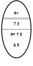
2.5.8.5 Examples of Ice Regimes and their IN calculations
The following examples are realistic IN calculations based on ice “eggs” from the CIS Daily Ice Charts. For each case, two different vessels were used to illustrate how the INs fluctuate for the same ice with structurally different vessels.
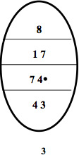
Example 1
Example 1 - Ice egg
Interpretation:
The Ice Regime consists of 8/10ths total ice concentration of which: 1/10th is Old ice and 7/10ths Thick first-year ice. While doing the calculation remember to incorporate the 2/10ths of Open water.
Ice numeral calculations:
- Type A vessel:
- (1 x -4) + (7 x -1) + (2 x 2 for open water) = -7
- Negative Regime
- CAC 4 vessel:
- (1 x -4) + (7 x +1) + (2 x 2 for open water) = +7
- Positive Regime
With Ridged thick first-year ice the IN calculations would be:
- Type A vessel
- (1 x -4) + (7 x -2) + (2 x 2 for open water) = -14
- Negative Regime
- CAC 4 vessel:
- (1 x -4) + (7 x 0) + (2 x 2 for open water) = 0
- [Positive Regime]
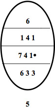
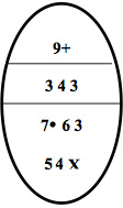
Example 2
Example 2 - Ice egg
Interpretation:
This July 9th Ice Regime consists of 6/10ths total concentration of ice of which 1/10th is Old ice, 4/10ths is Thick First-Year and 1/10th of Medium First-Year ice.
Ice numeral calculations:
- Type E vessel
- (1 x -4) + (4 x -3) + (1 x -2) + (4 x +2, open water) = -10
- Negative
- Type A vessel
- (1 x -4) + (4 x -1) + (1 x +1) + (4 x +2, open water) =+1
- Positive
or If this regime happened to be Decayed based upon data on an ice chart:
With Decayed ice (all Ice Types) the IN calculations are:
- Type E vessel
- (1 x -3) + (4 x -2) + (1 x -1) + (4 x +2, open water) =-4
- Negative
- Type A vessel
- (1 x -3) + (4 x 0) + (1 x +2) + (4 x +2, open water) =+7
- Positive
Example 3
Example 3 - Ice egg
Interpretation:
The Ice Regime consists of 9/10ths plus total concentration1 of ice in which there is a trace of Multi-Year ice, 7/10ths Thin First-Year and 3/10ths of Grey-White ice.
(NOTE: A trace of Multi-Year or Old ice creates a high risk transit.)
Ice numeral calculations:
CAC 4 vessel:
- (7 x 2) + (3 x 2) = +20
- Positive
Type C vessel:
- (7 x -1) + (3 x 1) = -4
- Negative
(Traces of ice are not factored in the calculation, i.e. under 1/10th)
Example 4
Example 4 - Ice egg
Interpretation:
This data that has been interpreted from remote sensing imagery indicates that this regime of 9/10ths plusFootnote 6 ice, consists of: 3/10ths Old ice, 4/10ths of First-Year (considered thick) and 3/10ths of Young ice (considered Grey-White).
Ice numeral calculations:
Type B vessel:
- (3 x -4) + (4 x -2) + (3 x +1) = -17
- Negative Regime
CAC 3 vessel:
- (3 x -1) + (4 x +2) + (3 x +2) = +11
- Positive Regime
2.5.8.6 Negative INs
While using the Ice Regime System, intentional entry into a negative ice regime outside the Zone/Date limits is prohibited. While navigating in the Arctic, the Mariner or Ice Navigator should consider several options to avoid encountering negative regimes:
- selecting a safe route composed entirely of positive regimes
- obtaining more recent and / or higher quality ice information
- waiting for improved weather or ice conditions
- requesting the assistance of an icebreaker by calling NORDERG
NORDREG CANADA and the CCG Icebreaking Superintendent will be able to provide additional information to assist in these circumstances and will have up-to-date knowledge of the positions of icebreakers.
Escorted operations
When ice conditions prevent, or significantly impede a vessel’s operations, it may be desirable or necessary to work together with another vessel or be escorted. Escorted operations are specifically allowed for in the Ice Regime System, and must be considered on an individual basis while planning routes and defining local ice regimes. Under some circumstances an escort can be effective in easing the ice conditions along the route, however, if the escort’s broken track is too narrow, if the ice is under pressure, the effectiveness of an escort can be severely limited.
The icebreaker will decide whether it is safe to break a track, but the Master of the escorted vessel must continue to evaluate the conditions in order to decide whether it is safe to follow, and at what speed. Communications and operating procedures must be established before any escort operation starts and maintained throughout. The following are factors to consider regarding the escort:
- the width of the broken track, in comparison with the following ship's beam
- the size, thickness, and strength of the ice pieces left in the track
- the likelihood of pressure conditions, which may cause the track to close rapidly
The track of an escort and surrounding conditions should be treated as a separate Ice Regime. Extreme caution must be exercised when working in an icebreaker’s track due to the confined aspect of the track.
Early season voyage
An early season voyage can be described as a voyage where the vessel intends to enter the Arctic prior to the main onset of melt and expects to enter a zone outside of the Zone / Date System. Entry could be possible under the Ice Regime System if there is an indication of positive INs. In this case it will be necessary for the vessel to have on board an Ice Navigator and send an Ice Regime Routing Message to NORDREG CANADA. Following the voyage an After Action Report must be submitted even though only positive INs may have been encountered.
Late season voyage
Late season voyages deserve special attention because of the certainty that ice conditions will worsen during the voyage, and the possibility that they will deteriorate rapidly. Severe, late season storms can cause pressure events and move large quantities of Multi-Year ice from high latitudes into the shipping channels.
With these voyages, a vessel may wish to enter a zone outside the Zone / Date System and entry is permitted provided there is an Ice Navigator on board, an Ice Regime Routing Message is sent to NORDREG CANADA that illustrates positive ice regimes. On late season voyages this communication with NORDREG CANADA is very important considering that the availability of Icebreaker support may be crucial if ice conditions deteriorate rapidly.
2.5.9 Guidelines for the Operation of Passenger Vessels in Canadian Arctic Waters - TP 13670 E
The objective of the Guidelines for the Operation of Passenger Vessels in Canadian Arctic Waters - TP 13670 E is to assist cruise operators, and their agents, in the planning of Arctic cruises and in making contact with all relevant Canadian government authorities well in advance to ensure that all the required publications are on board the vessels and have been studied before entering Canadian Arctic waters and that the operation complies with all applicable regulations.
2.5.10 Marine Environmental Handbook, Arctic Northwest Passage
The Marine Environmental Handbook for the Arctic Northwest Passagewas compiled to provide information on the Arctic environment to mariners who are planning to use the busiest part of the Northwest Passage. The handbook describes the adverse environmental effects that could arise from shipping activities on the traditional use patterns on the ice surface (hunting and transportation) or on bird, animal or fish populations. It also suggests mitigating measures for vessel operations, on-ice vehicles and aircraft. It can be purchased from an authorized Canadian Hydrographic Service (CHS) chart dealer.
Examples of the environmental sensitivity to marine shipping in the Southern route of the Northwest Passage in the Autumn are shown in Figures 10 and 11.
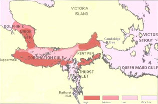
Figure 10 - Environmental sensitivity in Coronation Gulf in the Fall
Text version: Environmental sensitivity in Coronation Gulf in the Fall
A partial Arctic map focusing mostly on Coronation Gulf (South of Victoria Island) with different shades identifying the different levels of environmental sensitivity: Very Low (white-pink), Low (soft pink), Medium (pink) and High (red). For example, these shaded zones can be relevant to Caribous' migrations.

Figure 11 - Environmental sensitivity to vessels in Lancaster Sound in the Fall
Text version: Environmental sensitivity to vessels in Lancaster Sound in the Fall
A partial Arctic map focusing mostly on Northern Baffin Island to Barrow Strait near Resolute. The different shades identifying the different levels of environmental sensitivity: Very Low (white-pink), Low (soft pink), Medium (pink) and High (red). Per example, these shaded zones can be relevant to certain whales common habitats.
- Date modified: