
Radio Aids to Marine Navigation 2024
Part 4: General
4.1 Procedures
4.1.1 Radiotelephone Procedures
4.1.1.1 General
In the interest of safe navigation, and especially during bad weather conditions, masters should ensure that a continuous listening watch is maintained on 2182 kHz. Where practicable, and having due regard for Vessel Traffic Services and Seaway Control requirements, a listening watch should be maintained on VHF Ch16 (156.800 MHz).
2182 kHz and Ch16 (156.800 MHz) shall only be used for distress, urgency and safety communications and for calling purposes. The class of emission to be used for radiotelephony on the frequency 2182 kHz shall be J3E.
Initial calls must be made directly on the safety and calling frequency 2182 kHz or Ch16. This procedure is required because the MCTS Centres do not monitor MF/VHF working frequencies.
Masters of compulsorily-fitted ships are reminded that a radio log of all distress and urgency communications and safety communications pertaining to their own ship should be kept and maintained onboard their vessels.
4.1.1.2 The following examples will illustrate the procedure to be used
| Item | Spoken |
|---|---|
| Name of station called (spoken three times). | PRESCOTT COAST GUARD RADIO |
| The words "THIS IS". | THIS IS |
| Type, name, radio call sign of vessel calling (spoken three times). | STEAMER FAIRMOUNT CYLD |
| Invitation to reply | OVER |
| Item | Spoken |
|---|---|
| General call (spoken three times). | ALL STATIONS (or ALL SHIPS IN JOHNSTONE STRAITS) |
| The words “THIS IS”. | THIS IS |
| Type, name and radio call sign of vessel calling (spoken three times). | TANKER IMPERIAL CORNWALL/VCVC |
| Invitation to reply. | OVER |
When a station wishes to broadcast information rather than to establish communication, it proceeds with the message instead of giving the invitation to reply.
A radio message from a ship consists of several parts which shall be transmitted on the working frequency in the following order:
- type, name and radio call sign of the originating ship;
- the date and time the message originated (Preferably in UTC. Daylight Saving Time shall not be used). [date and time may be sent as one group, the first two figures indicate the date, the last four the time];
- the address;
- the text or body of the message;
- the signature.
Note: Items a) and b), taken together, are known as the “preamble.”
| Item | Spoken |
|---|---|
| Message | FROM M/V WEST WIND, CALL SIGN V2AG |
| Filed | 071225UTC |
| Address | ECAREG CANADA |
| Text | SECURED SYDNEY GOVERNMENT WHARF |
| Signature | MASTER |
An acknowledgment of receipt of a message shall not be given until the receiving operator is certain that the transmitted information has been received correctly.
While it is not practical to lay down precise words and phrases for all radiotelephone procedures, the following should be used where applicable.
| Terms | Meaning |
|---|---|
| ACKNOWLEDGE | Let me know that you have received and understood this message. |
| CORRECTION | An error has been made in this transmission. The correct version is... |
| GO AHEAD | Proceed with your message. |
| OVER | My transmission is ended and I expect a response from you. |
| OUT | This conversation is ended and no response is expected. |
| READ BACK | After I have given OVER, repeat all the message back to me exactly as received. |
| ROGER | I have received all of your last transmission. |
| RECEIVED NUMBER | Receipt of your message number ... is acknowledged. |
| STAND BY | Wait until you hear further from me. |
| VERIFY | Check with the originator and send the correct version. |
| WORDS TWICE | As a request - Please send each word twice. As information - I will send each word twice. |
4.1.1.3 Phonetic Alphabet
When it is necessary to spell out call signs, service abbreviations and words whose spelling might be misinterpreted, the following letter spelling table should be used:
A - ALFA
B – BRAVO
C - CHARLIE
D - DELTA
E - ECHO
F - FOXTROT
G - GOLF
H - HOTEL
I - INDIA
J - JULIET
K - KILO
L – LIMA
M - MIKE
N - NOVEMBER
O - OSCAR
P - PAPA
Q - QUEBEC
R – ROMEO
S - SIERRA
T - TANGO
U - UNIFORM
V - VICTOR
W – WHISKEY
X - X-RAY
Y – YANKEE
Z - ZULU
4.1.1.4 Times
Times are expressed in four figures, the first two denoting the hour and the last two the minutes, the day starting at midnight with 0000 and ending at 2400. The standard of time (e.g. UTC) is stated at the head of the appropriate column, or against the figures involved.
4.1.1.5 Time Zone Comparison
- NST Newfoundland Standard Time
- AST Atlantic Standard Time
- EST Eastern Standard Time
- CST Central Standard Time
- MST Mountain Standard Time
- PST Pacific Standard Time
To convert from Coordinated Universal Time to Local Standard Time look opposite UTC under the appropriate column. For corresponding Daylight Saving Time, add one hour.
| UTC | NST | AST | EST | CST | MST | PST |
|---|---|---|---|---|---|---|
| 00:00 | 20:30 | 20:00 | 19:00 | 18:00 | 17:00 | 16:00 |
| 01:00 | 21:30 | 21:00 | 20:00 | 19:00 | 18:00 | 17:00 |
| 02:00 | 22:30 | 22:00 | 21:00 | 20:00 | 19:00 | 18:00 |
| 03:00 | 23:30 | 23:00 | 22:00 | 21:00 | 20:00 | 19:00 |
| 04:00 | 00:30 | 00:00 | 23:00 | 22:00 | 21:00 | 20:00 |
| 05:00 | 01:30 | 01:00 | 00:00 | 23:00 | 22:00 | 21:00 |
| 06:00 | 02:30 | 02:00 | 01:00 | 00:00 | 23:00 | 22:00 |
| 07:00 | 03:30 | 03:00 | 02:00 | 01:00 | 00:00 | 23:00 |
| 08:00 | 04:30 | 04:00 | 03:00 | 02:00 | 01:00 | 00:00 |
| 09:00 | 05:30 | 05:00 | 04:00 | 03:00 | 02:00 | 01:00 |
| 10:00 | 06:30 | 06:00 | 05:00 | 04:00 | 03:00 | 02:00 |
| 11:00 | 07:30 | 07:00 | 06:00 | 05:00 | 04:00 | 03:00 |
| 12:00 | 08:30 | 08:00 | 07:00 | 06:00 | 05:00 | 04:00 |
| 13:00 | 09:30 | 09:00 | 08:00 | 07:00 | 06:00 | 05:00 |
| 14:00 | 10:30 | 10:00 | 09:00 | 08:00 | 07:00 | 06:00 |
| 15:00 | 11:30 | 11:00 | 10:00 | 09:00 | 08:00 | 07:00 |
| 16:00 | 12:30 | 12:00 | 11:00 | 10:00 | 09:00 | 08:00 |
| 17:00 | 13:30 | 13:00 | 12:00 | 11:00 | 10:00 | 09:00 |
| 18:00 | 14:30 | 14:00 | 13:00 | 12:00 | 11:00 | 10:00 |
| 19:00 | 15:30 | 15:00 | 14:00 | 13:00 | 12:00 | 11:00 |
| 20:00 | 16:30 | 16:00 | 15:00 | 14:00 | 13:00 | 12:00 |
| 21:00 | 17:30 | 17:00 | 16:00 | 15:00 | 14:00 | 13:00 |
| 22:00 | 18:30 | 18:00 | 17:00 | 16:00 | 15:00 | 14:00 |
| 23:00 | 19:30 | 19:00 | 18:00 | 17:00 | 16:00 | 15:00 |
4.1.1.6 Time Signals
Canada’s official time is the responsibility of the National Research Council’s Metrology Research Centre, Ottawa, ON. Its short wave radio station CHU, with transmitters located at 45º17’47”N 075º45’22”W is equipped with vertical antennas to give the best possible coverage to the maximum number of Canadian users. The signal is transmitted continuously on 3330 kHz, 7850 kHz and 14670 kHz, upper single-sideband H3E (AM compatible). A cesium atomic clock generates the carrier frequencies (accurate to a part in 10-11) and the UTC seconds pulses (accurate to 50 microseconds). The start of each UTC second is marked by the start of 300 cycles of a 1000 Hz tone, with certain omissions and identifications. Every half-minute is marked by omitting the preceding tone (for second 29). In the 9 seconds preceding each minute, the second pulses are shortened to “ticks” to provide a window for the voice announcement, followed by a longer tone. The start of this tone marks the exact minute given by the announcement. This tone is one-half second long, except for the exact hour - when it is one full second long and in this case only is followed by 9 seconds of silence.
The bilingual voice announcement which is heard each minute takes the form:
“CHU Canada - Coordinated Universal Time -- hours -- minutes -- heures -- minutes” for odd minutes,
and
“CHU Canada - Temps Universel Coordonné -- heures -- minutes -- hours -- minutes” for even minutes.
A small number of the longer time announcements use the abbreviation “UTC” rather than the full form.
Following international practice, Canada’s official time is based on Coordinated Universal Time (UTC) which is kept within one second of UT1, the time on the Greenwich meridian as used for celestial navigation. Users interested in the ultimate accuracy of celestial navigation can determine UT1 with an accuracy of 0.1 seconds by decoding the difference DUT1 = UT1 - UTC, as transmitted by CHU in the internationally accepted code. The number of tenths of a second of DUT1 can be decoded by counting the number of emphasized second pulses that follow each minute. If the emphasized pulses occur for any of the seconds 1 to 8, DUT1 is positive; if the emphasized pulses occur for any of the seconds 9 to 16, DUT1 is negative. CHU emphasizes second pulses by splitting them (0.1 s of tone, 0.1 s of silence, 0.1 s of tone) so that a double tone is heard.
4.1.2 Distress Communications in Radiotelephony
4.1.2.1 Early Notification of Search and Rescue Authorities of Developing Situations
In the interest of ensuring the highest level of safety, mariners should immediately notify the Canadian Coast Guard, through any MCTS Centre of any situation which is or may be developing into a more serious situation requiring assistance from the Search and Rescue (SAR) System. The need for the earliest possible alerting of SAR Authorities to potential maritime emergencies cannot be over-emphasized.
This advice is given in accordance with IMO Circular MSC/Circ.892 and similar advice found in the ICAO/IMO International Aeronautical and Maritime SAR (IAMSAR) Manual Volume III. Further, there have been similar recommendations arising from serious SAR cases in the Canadian SAR Region where masters have failed to provide this notice until after the situation deteriorated.
This notification allows SAR authorities to carry out preliminary and contingency planning that could make a critical difference if the situation worsens. Time lost in the initial stages of a SAR mission may be crucial to its eventual outcome.
It is always best to consider the worst-case scenario and to alert SAR authorities accordingly. This notification places no obligations upon the master except to advise the CCG when the situation has been corrected.
Canadian MCTS Centres provide coverage of all marine distress frequencies, however, each centre does not necessarily guard each frequency (refer to centre listings in Part 2). MCTS provides communications between the JRCC/MRSC and the vessel or vessels concerned with the distress.
The radiotelephone distress frequencies are:
- 2182 kHz on medium frequency (MF) band;
- 156.800 MHz (Ch 16) on very high frequency band (VHF); and
- any other available frequency on which attention might be attracted if transmissions on 2182 kHz and 156.800 MHz are not possible or successful.
The digital selective calling (DSC) frequencies are:
- 156.525 (Ch 70) in the VHF band;
- 4207.5 kHz;
- 6312.0 kHz;
- 8414.5 kHz;
- 12577 kHz; and
- 16804.5 kHz in the High Frequency (HF) bands.
When another craft or person is in distress:
- all transmissions capable of interfering with the distress traffic must be stopped;
- attention must be concentrated on the distress communications and all information possible intercepted; and
- station in the vicinity of the distressed craft must acknowledge receipt of the distress message if received, giving its own position in relation to that of the craft in distress and stating the action being taken.
Distress communications consist of the:
- distress Alert (when using VHF or HF DSC);
- distress Signal;
- distress Call;
- distress Message; and
- distress Traffic.
Transmission of a DSC Distress Alert, a Distress Signal and/or a Distress Call announces that the ship, aircraft, other vehicle, or person that is making the transmission is:
- threatened by serious and imminent danger and requires immediate assistance; or
- aware of another ship, aircraft, other vehicle, or person threatened by serious and imminent danger and requires immediate assistance.
Distress communications should be repeated by the craft in distress until an answer is heard.
The DSC Distress Alert will automatically switch marine radios to the associated distress frequency for the subsequent transmission of the distress signal, the distress call and the distress message.
4.1.2.2 The Alarm Signal
The radiotelephony Audio Alarm Signal consists of a two tone audio transmission followed by a ten second continuous tone. The two tones are different pitches, similar to the sound of emergency vehicles, and the ten second continuous tone indicates that the transmission is from an MCTS Centre.
The Audio Alarm Signal is used to alert mariners that:
- A distress call or distress message is about to follow;
- There is a new warning pertaining to a dangerous weather phenomena (only the initial broadcast)
- A tsunami warning broadcast is about to follow (only the initial broadcast); or,
- There has been an observed or reports of a dangerous weather phenomena, such as a waterspout.
4.1.2.3 The Distress Signal
The Distress Signal consists of the word “MAYDAY”.
The Distress Call consists of:
- the word “MAYDAY” (spoken three times);
- the words “THIS IS” followed by;
- the name of the ship in distress (spoken three times);
- the call sign or other identification; and
- the ship's MMSI (if a DSC distress alert has been sent).
The Distress Call:
- should not be addressed to a particular coast radio station or ship; and
- has absolute priority over all other transmissions and all coast radio stations and ships that hear this call must cease any transmissions that will interfere with it and must listen on the frequency used for this call.
The Distress Message consists of:
- the word “MAYDAY”;
- the name of the ship in distress;
- the call sign or other identification;
- the ship’s MMSI (if a DSC distress alert has been sent);
- the position of the ship in distress;
- the nature of the distress;
- the kind of assistance needed;
- any other useful information which might assist the rescue; and
- the word “OVER”, which is an invitation to acknowledge and reply.
The DSC Distress Alert Acknowledgement to an “All Stations” DSC Distress Alert shall normally be made by an MCTS Centre.
Ship stations may acknowledge receipt of a DSC Distress Alert by radiotelephony on the associated distress and calling frequency after an MCTS Centre has had time to initiate contact with the vessel in distress.
4.1.2.4 Distress Traffic
Distress Traffic consists of all messages about the immediate assistance required by the ship in distress. Prior to the transmission of any Distress Traffic, the Distress Signal “MAYDAY” must be sent once before the call. The control of Distress Traffic is the responsibility of the ship in distress or of the ship or coast radio station sending a Distress Message.
A mobile station that learns that another mobile station is in distress may transmit the distress message if:
- the station in distress cannot transmit it;
- the master or person responsible for the craft carrying the station which intervenes believes that further help is necessary; and
- although not in a position to render assistance, it has heard a distress message which has not been acknowledged.
In the above situation the distress message relay takes the following form:
- the radiotelephone Alarm Signal, if possible;
- the words “MAYDAY RELAY” (spoken three times);
- the words “ALL STATIONS” or a specific MCTS Centre, as appropriate (spoken three times);
- the words “THIS IS”;
- the name of the mobile station repeating the distress message (spoken three times);
- the call-sign or other identification of the mobile station repeating the distress message;
- the MMSI of the mobile station repeating the distress message (if the initial distress alert was sent by DSC);
- the repetition of the distress message; and
- the word, “OVER”.
When Distress Traffic has ceased or when silence is no longer necessary the station that has controlled the Distress Traffic must transmit a message on the distress frequency advising that the distress traffic has ceased.
- the word “MAYDAY”;
- the words “ALL STATIONS” (spoken three times);
- the words “THIS IS”;
- the name of the station which has controlled the distress traffic (spoken three times);
- the call-sign or other identification of the station which has controlled the distress traffic;
- the date/time of the initial report in Coordinated Universal Time (UTC);
- the MMSI (if the initial distress alert was sent by DSC) and the name and call sign of the ship that was in distress and a brief description of the resolution of the distress;
- the words “SEELONCE FEENEE”; and
- the word “OUT”.
4.1.2.5 Distress Procedure Example
Initiate a VHF or HF DSC Distress Alert.
Then, on the associated distress and calling frequency, the following distress call and distress message should be spoken slowly and distinctly:
| Item | Spoken |
|---|---|
| Distress Signal | “MAYDAY” (three times) |
| The words | “THIS IS” |
| Name of ship | “Nonsuch” (three times) |
| MMSI number | “316010115” (if initial distress alert was sent by DSC) |
| Distress Signal | “MAYDAY” |
| Position | “Off Îles Sainte-Marie ” |
| Nature of distress | “Struck rock and taking on water” |
| Assistance needed | “Require help to abandon ship” |
| Other useful information | “5 persons on board” |
| Invitation to acknowledge and reply | “OVER” |
4.1.3 Urgency Communications
The DSC Urgency Announcement will automatically switch marine radios to the associated distress frequency for the subsequent transmission of the urgency signal, the urgency call and the urgency message.
The Urgency Signal consists of the words “PAN PAN”.
The Urgency Call consists of:
- the words “PAN PAN” (spoken three times);
- the words “ALL STATIONS” or station specific call (spoken three times);
- the words “THIS IS” followed by;
- the name of the station making the call (spoken three times);
- the call-sign or other identification; and
- the ship's MMSI (if the initial Urgency announcement was sent by DSC).
The urgency signal may be transmitted only on the authority of the master or the person responsible for the ship, aircraft or other vehicle carrying the mobile station.
The urgency signal indicates that the calling station has a very urgent message to transmit concerning the safety of a ship, aircraft or other vehicle, or the safety of a person.
The urgency signal, the urgency call, and the urgency message shall be sent on the distress frequencies 2182 kHz and Ch16 (156.800 MHz). If transmission on these frequencies is impossible, any other available frequency on which attention might be attracted should be used.
The urgency signal has priority over all other communications, except distress, and all stations which hear it must take care not to interfere with the transmission of the message which follows the urgency signal.
Stations which hear the urgency signal must continue to listen for at least three minutes. At the end of this period, if no urgency message has been heard, normal service may be resumed. However, stations which are in communication on frequencies other than those used for transmission of the urgency signal may continue their normal work without interruption provided the urgency message is not addressed “to all stations”.
The DSC Urgency Acknowledgement to an “All Stations” DSC Urgency Announcement shall normally be made by an MCTS Centre. Ship stations may acknowledge, by radiotelephony, the receipt of a DSC Urgency Announcement on the associated distress and calling frequency after a MCTS Centre has had time to initiate contact with the vessel in distress.
4.1.4 Safety Communications
The Safety Signal consists of the word “SÉCURITÉ”.
The Safety Call consists of:
- the word “SÉCURITÉ” (spoken three times);
- the words “ALL STATIONS” (spoken three times);
- the words “THIS IS”, followed by;
- the name of the station making the call (spoken three times);
- the call-sign or other identification;
- the station's MMSI (if the initial Safety announcement was sent by DSC);
- a brief description of the context of the “Safety Message”;
- the channel or frequency for the Safety broadcast; and
- the word “OUT”.
The safety signal indicates that the station is about to transmit an important navigational or meteorological warning. The safety message should be sent on a working frequency, which is announced at the end of the call.
The safety call is transmitted on the distress frequencies 2182 kHz and Ch16 (156.800 MHz). If transmission on these frequencies is impossible, any other available frequency on which attention might be attracted shall be used.
A ship station which receives an “All Stations” DSC Safety Announcement shall not acknowledge receipt.
All stations hearing the safety signal shall shift to the working frequency indicated in the call and listen to the safety message until satisfied it does not concern them.
The Safety Message format consists of:
- the word “SÉCURITÉ”;
- the words “ALL STATIONS” (spoken three times);
- the words “THIS IS”, followed by;
- the name of the station making the call (spoken three times);
- the call sign or other identification of the transmitting station;
- the MMSI of the transmitting station (if the initial announcement was sent by DSC);
- the details of the safety message;
- the word “OUT”.
4.1.4.1 Safety Communications in Athabasca – Mackenzie Watershed Area
DISTRESS, URGENCY, SAFETY COMMUNICATIONS – USE OF 5803 kHz
The frequency 5803 kHz is the distress and calling frequency for the Athabasca – Mackenzie inland waterways. This frequency should be carried on all commercial vessels and should be monitored at all times when the vessel is in active operation on the waterways.
This frequency will not be used for any type of communication other than distress, urgency and safety communications and for the purpose of establishing initial radio contact with another vessel or shore station. After initial contact is made, for other than distress or emergency communication, the vessel and/or shore station involved will immediately transfer to an established working frequency.
For the provision of relay or assistance in communication to a land station or other vessel, the CCG will provide, during the shipping season, 24 hour receive and transmit facilities on 5803 kHz from Iqaluit MCTS/VFF.
Figure 4-1 - Distress and Safety Radiotelephone Procedures
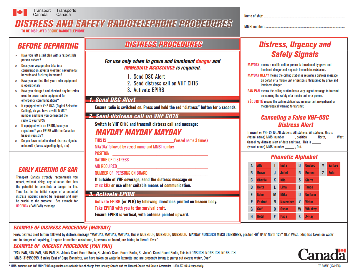
Figure 4-1 Distress and safety radiotelephone procedures - Text version
DISTRESS PROCEDURES
For use only when in grave and imminent danger and IMMEDIATE ASSISTANCE is required.
- Send DSC Alert
- Send distress call on VHF CH16
- Activate EPIRB
1. Send DSC Alert
Ensure radio is switched on. Press and hold the red “distress” button for 5 seconds.
2. Send distress call on VHF CH16
Switch to VHF CH16 and transmit distress call and message:
MAYDAY MAYDAY MAYDAY
THIS IS (Vessel name 3 times)
MAYDAY followed by vessel name and MMSI number
POSITION
NATURE OF DISTRESS
AID REQUIRED
NUMBER OF PERSONS ON BOARD
If outside of VHF coverage, send the distress message on 2182 kHz or use other suitable means of communication.
3. Activate EPIRB
Activate EPIRB (or PLB) by following directions printed on beacon body.
Take EPIRB with you to the survival craft.
Ensure EPIRB is vertical, with antenna pointed upward.
Before Departing
- Have you left a sail plan with a responsible person ashore?
- Does your voyage plan take into consideration adverse weather, navigational hazards and fuel requirements?
- Have you verified that your radio equipment is operational?
- Have you charged and checked any batteries used to power radio equipment for emergency communications?
- If equipped with VHF-DSC (Digital Selective Calling), do you have a valid MMSI* number and have you connected the radio to your GPS?
- If equipped with an EPIRB, have you registered* your EPIRB with the Canadian beacon registry?
- Do you have suitable visual distress signals onboard? (fl ares, signaling light, etc)
Early Alerting of SAR
Transport Canada strongly recommends you report, without delay, any situation that has the potential to constitute a danger to life. Time lost in the initial stages of a potential distress incident cannot be regained and may be crucial to the outcome. See example for
URGENCY (PAN PAN) message.
Distress, Urgency and Safety Signals
MAYDAY means a mobile unit or person is threatened by grave and imminent danger and requests immediate assistance.
MAYDAY RELAY means the calling station is relaying a distress message on behalf of a mobile unit or person is threatened by grave and imminent danger.
PAN PAN means the calling station has a very urgent message to transmit concerning the safety of a mobile unit or a person.
SÉCURITÉ ÉCURITÉ means the calling station has an important navigational or meteorological warning to transmit.
Canceling a False VHF-DSC Distress Alert
Transmit on VHF CH16: All stations, All stations, All stations, this is (vessel name) MMSI number, position, North, West, Cancel my distress alert of date and time. This is (vessel name) MMSI number , Out.
Phonetic Alphabet
A Alfa I India Q Quebec Y Yankee
B Bravo J Juliet R Romeo Z Zulu
C Charlie K Kilo S Sierra
D Delta L Lima T Tango
E Echo M Mike U Uniform
F Foxtrot N November V Victor
G Golf O Oscar W Whiskey
H Hotel P Papa X X-Ray
EXAMPLE OF DISTRESS PROCEDURE (MAYDAY)
Press distress alert button followed by distress message “MAYDAY, MAYDAY, MAYDAY, This is NONSUCH, NONSUCH, NONSUCH. MAYDAY NONSUCH MMSI 316999999, position 49° 04.6’ North 123° 18.8’ West. Ship has taken on water and in danger of capsizing, I require immediate assistance, 4 persons on board, are taking to life raft, Over.”
EXAMPLE OF URGENCY PROCEDURE (PAN PAN)
“PAN PAN, PAN PAN, PAN PAN, St. John’s Coast Guard Radio, St. John’s Coast Guard Radio, St. John’s Coast Guard Radio, This is NONSUCH, NONSUCH, NONSUCH.
MMSI 316999999, 5 miles East of Cape Bonavista, we have taken on water in lazarette and are presently trying to pump out excess water, Over”.
4.1.5 Aids to Navigation
4.1.5.1 Positions
All positions expressed in latitude and longitude of the radio aids to navigation listed in this publication are approximate and are taken from the largest scale Canadian Hydrographic Service charts, where available, or British Admiralty charts of the vicinity. Mariners should bear in mind when plotting the position of any given aid that it is preferable to use a chart with the aid already located on it than to plot it from a position given in latitude and longitude.
4.1.5.2 Reporting Abnormal Operation of Radio Aids
A marine radio aid observed to be operating abnormally should be reported, as soon as possible to an MCTS Centre.
Reports shall be as complete as possible, giving full details including time, date, the position from which the observation was made, and details and description of conditions, such as weather and reception, prevailing at the time of the observation.
It is also requested that ships report abnormal MCTS Centre operation, such as poor quality of marine telephone calls, unreadability of broadcasts, failure to answer calls, etc.
To ensure prompt corrective action, such reports must include the date, time and position of ship when the observation was made, together with details of prevailing weather and reception conditions.
4.1.5.3 Radio Beacons
Marine radio beacons generally operate in the 285-325 kHz. Radio beacon service enables ships fitted with direction finding equipment to take a bearing or to take several consecutive bearings which will provide a fix. See Part 2.5 for details on individual listings.
4.1.5.4 Radar Beacons (RACONS)
Radar beacons (Racons) may be established at lighthouses, on buoys or at other specific charted locations ashore or afloat to enhance identification and detection range of these features by radar.
Some Racons operate only in the X band 9320-9500 MHz, whilst others are dual band X/S, X band plus S band of 2920-3100 MHz. It should also be noted that the slow sweep (SS) type of Racon will give a response every 72-120 seconds, whilst the Frequency Agile Racon (FAR) will respond more frequently.
The Racon signal appears on the radar display as a line commencing at the approximate range of the Racon and extending outwards along its line of bearing from the ship toward the limit of the display. The signal displayed may be a solid line or it may be broken into a code consisting of a series of dots and dashes as shown in relevant publications. See Part 2.6 for details on individual listings.
4.2 Systems
4.2.1 Global Maritime Distress and Safety System in Canada (GMDSS)
4.2.1.1 What is GMDSS?
The Global Maritime Distress and Safety System (GMDSS) is an international system using improved terrestrial and satellite technology and ship-board radio systems. It ensures rapid alerting of shore-based rescue and communications authorities in the event of an emergency. In addition, the system alerts vessels in the immediate vicinity and provides improved means of locating survivors.
GMDSS was developed through the International Maritime Organization (IMO) and represents a significant change in the way maritime safety communications are conducted. While it is mandatory for all ships subject to the International Convention for the Safety Of Life At Sea (SOLAS) (cargo ships 300 gross tons or greater and all passenger vessels, on international voyages), GMDSS will impact on all radio-equipped vessels, regardless of size. All SOLAS ships are required to fully comply with GMDSS.
4.2.1.2 Why GMDSS?
GMDSS was developed to save lives by modernizing and enhancing the current radiocommunications system. By utilizing satellite and digital selective calling technology, GMDSS provides a more effective distress alerting system. It improves the current system by:
- increasing the probability that an alert will be sent when a vessel is in distress;
- increasing the likelihood that the alert will be received;
- increasing the ability to locate survivors;
- improving rescue communications and coordination; and
- providing mariners with vital maritime safety information.
4.2.1.3 Maritime Safety Information (MSI)
Maritime Safety Information broadcasts, which comprise navigational and meteorological warnings, meteorological forecasts and other safety-related messages can be received in four different ways in GMDSS:
- NAVTEX receivers are fully automatic and receive broadcasts in coastal regions up to 300 nautical miles offshore;
- Terminals to receive Enhanced Group Calls (EGC) for areas outside NAVTEX coverage using SafetyNET, SafetyNET II and SafetyCast;
- High Frequency Narrow-Band-Direct-Printing (HF NBDP) receivers may be used where service is available to promulgate MSI; and
- VHF marine radio (Sea Area A1) as a medium for obtaining nav/met MSI.
4.2.1.4 GMDSS Sea Areas - International
Although ship-to-ship alerting is still an important function in GMDSS, the emphasis is on two-way communications between ships and shore facilities. All GMDSS ships must be capable of communicating with the shore and transmitting a distress alert by two different means. The equipment carried by a GMDSS ship is therefore determined by its area of operation and the availability of shore-based communications services.
| Area | Description |
|---|---|
| Sea Area A1 | Within range of shore-based VHF/DSC coast station (40 nautical miles). |
| Sea Area A2 | Within range of shore-based MF/DSC coast station (excluding sea areas A1) (150 nautical miles). |
| Sea Area A3 | Sea Area 3 is that sea area of the world not being part of any sea area A1 or A2 within which the elevation angle of an Inmarsat satellite is 5 degrees or more. |
| Sea Area A4 | The remaining areas outside sea areas A1, A2 and A3 (polar regions). |
4.2.1.5 GMDSS Sea Areas - Canada
In Canada, as a result of consultations with the Canadian marine industry, Sea Area A1 and Sea Area A3 were implemented on the east and west coasts, and Sea Area A4 was implemented in the Arctic.
VHF-DSC services are provided in the Great Lakes and the St. Lawrence River west of the lower exit of the St. Lambert Lock.
Figure 4-2 - Canadian A1/A3/A4 GMDSS Sea Areas Theoretical Coverage
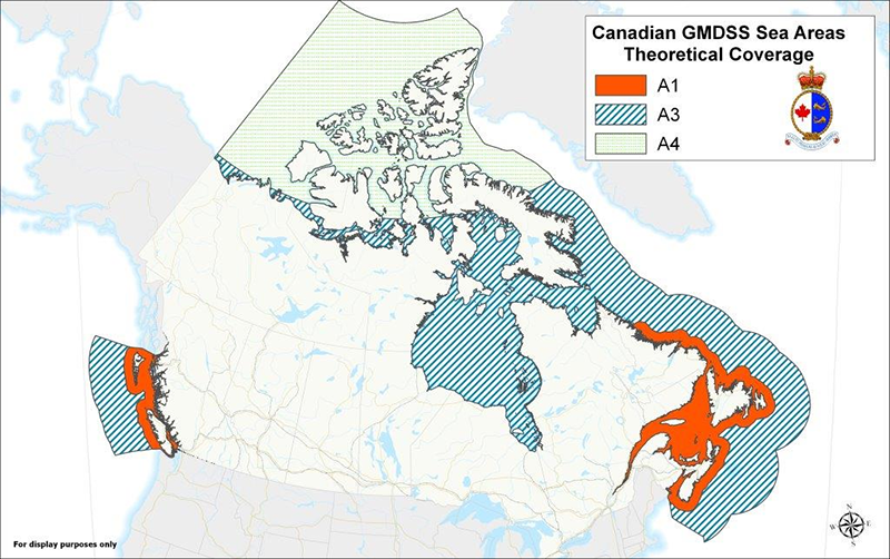
Figure 4-2 Canadian A1/A3/A4 GMDSS Sea Areas Theoretical Coverage - Text version
This map shows the Global Maritime Distress and Safety System – or GMDSS – Sea Areas A3 and A4 as they are considered in Canada. By definition, GMDSS Sea Area A3 is an area within the coverage of an INMARSAT geostationary satellite, between approximate latitudes of 70ºN and 70ºS and not within range of either a shore-based VHF/DSC (digital selective calling) coast station (Sea Area A1) or a shore-based MF/DSC coast station (Sea Area A2). By definition, GMDSS Sea Area A4 includes all the areas outside of sea areas A1, A2 and A3, and this results in Sea Area A4 being the polar regions.
Sea area A3 is that sea area of the world not being part of any sea area A1 or A2 within which the elevation angle of an Inmarsat satellite is 5 degrees or more.
4.2.1.6 Communications Between GMDSS Vessels and Non-GMDSS Vessels
Since February 1, 1999, GMDSS larger ships have been maintaining an automated listening watch on VHF/DSC Ch70 and MF/DSC 2187.5 kHz. This at times creates the situation, where vessels fitted with traditional, non-GMDSS radio equipment, may have had difficulties alerting or contacting a GMDSS ship. The CCG is addressing this by monitoring both GMDSS and traditional distress frequencies. Furthermore, the CCG and Transport Canada encourage all vessels to fit VHF/DSC in the interest of increased safety.
4.2.1.7 Important Safety Notice Concerning VHF/DSC
After having received a distress, urgency or safety broadcast announcement on VHF/DSC Ch70, the VHF/DSC equipment will automatically switch the DSC radio to VHF Ch16 for the subsequent voice announcements. Mariners who are required by the Navigation Safety Regulations, 2020 to monitor a specific VTS sector frequency should return the radio to the appropriate working frequency after determining, on Ch16, the impact of the VHF/DSC alert broadcast announcement on their vessel’s operations.
It has been determined that vessels maintaining a listening watch on a VTS sector frequency, per the requirements of the VTS Zone Regulations may, if navigating in congested waters, temporarily discontinue DSC watchkeeping on VHF/DSC Channel 70 until the required manoeuvre has been completed.
Vessels inadvertently or accidentally transmitting a distress/urgency/safety broadcast on VHF/DSC must cancel the distress/urgency/safety broadcast on VHF Ch16. Intentionally sending a false distress alert carries penalties under both the Canada Shipping Act, 2001 and the Radiocommunication Act.
VHF/DSC equipment must be programmed with the correct Maritime Mobile Service Identity (MMSI) numbers (reference “Radio Station Licensing and MMSI numbers” in Section 4.3.12, also reference Section 1.4 for the MCTS Centres’ MMSI numbers).
Figure 4-3 - Radio Coverage Prediction - Atlantic Ocean
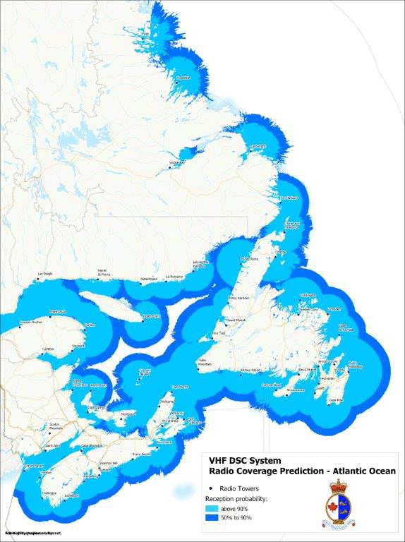
Figure 4-3 Radio Coverage Prediction Atlantic Ocean - Text version
This map illustrates eastern Canada which has been identified as Sea Area A1. Sea Area 1 is an area within the radiotelephone coverage of at least one very high frequency (VHF) coast station in which Digital Selective Calling (DSC) alerting is available. This map shows the radio coverage prediction of the VHF DSC system. It encompasses those waters within 40 nautical miles of the East Coast of Canada, as far north as Nain (Labrador – 57N), and as far west on the St. Lawrence River as a straight line from Cap-des-Rosiers through Pointe de l’Ouest, Anticosti Island extending along the north shore, the south shore and the Gulf of St. Lawrence, including those bays, coves and inlets that have unobstructed signal paths from VHF radio facilities, with the exception of the following areas of Newfoundland and Labrador: Rigolet, the eastern end of Lake Melville (54N to 55N), Black Tickle (52 30N to 53 30N) and White Bay (50N to 50 30N).
The map shows every communication site equipped with VHF DSC for the following MCTS centres Saint John, Halifax, Sydney, Port aux Basques, Placentia, St. John’s, St. Anthony, and Rivière-au-Renard. Each communication site is identified by a coloured dot corresponding to the controlling MCTS centre. Saint John MCTS sites are represented by pink dots. Halifax MCTS sites are represented by orange dots. Sydney MCTS sites are represented by yellow dots. Port-aux-Basques MCTS sites are represented by white dots. Placentia MCTS sites are represented by purple dots. St. John’s MCTS sites are represented by black circles. St. Anthony MCTS sites are represented by yellow dots circled in black and Rivière-au-Renard MCTS sites are represented by green dots circled in black. Areas of reception probability are indicated by three colours. Light green indicates reception probability of 50 to 90 percent. A darker green indicates reception probability of above 90 percent. Reception probability is at 90% or above for an area of up to approximately 35 nautical miles from each site indicated. For up to another 15 nautical miles from there reception probability is indicated at between 50 to 90%. There are areas of overlap indicated around Port-aux-Basques on the southwest coast of Newfoundland and an area to the east of les Iles-de-la- Madeleine and covering les Iles-de-la-Madeleine. There is also an area of overlap off of Miscou, NB and another between Pointe Riche, NL and Harrington Harbour, QC. There is a small area of no DSC coverage midway between Anticosti Island and les Iles-de-la-Madeleine.
Figure 4-4 - Radio Coverage Prediction – St. Lawrence
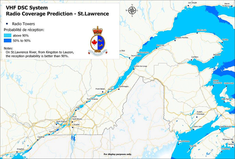
Figure 4-4 Radio Coverage Prediction - St. Lawrence - Text version
This map displays the radio coverage prediction of the VHF DSC System on a map that extends from the Gulf of St. Lawrence, including the coasts of New Brunswick, Nova Scotia and Prince Edward Island, to Lake Ontario. It represents the A1 area under the responsibility of the Atlantic regions as defined in the Global Maritime Distress and Safety System. Two shades of green are used to represent the VHF DSC coverage. Light green represents 50-90% reception probability of the VHF DSC signal, whereas dark green represents a 90+% reception probability of the VHF DSC signal, as specified in the legend in the white rectangle on the left-hand side of the map. The Les Escoumins (in black), Québec (in green), Longueuil (in yellow) and Prescott (in red) MCTS Centres and remotely controlled VHF DSC-equipped sites are indicated on the map in colours that correspond to their respective centres. The Les Escoumins MCTS Centre is the centre for the Mont-Louis, Grosses-Roches, Sainte-Flavie, Sacré-Cœur and Cap de l’Est sites; the Québec MCTS Centre is the centre for the Rivières-du-Loup, Montmagny, Lauzon, Bélair and Sainte-Marthe sites; the Longueuil MCTS Centre is the centre for the Saint-Bruno, l’Acadie and Rigaud sites, and the Prescott MCTS Centre is the centre for the Cornwall, Cardinal, Kingston and Cobourg sites, which are indicated. The title of the map in English and French, as well as the Canadian Coast Guard logo are found in the white rectangle in the upper left-hand corner. The scale is also indicated. The next chart is adjacent to this one and represents the Great Lakes.
Figure 4-5 - Radio Coverage Prediction - Great Lakes
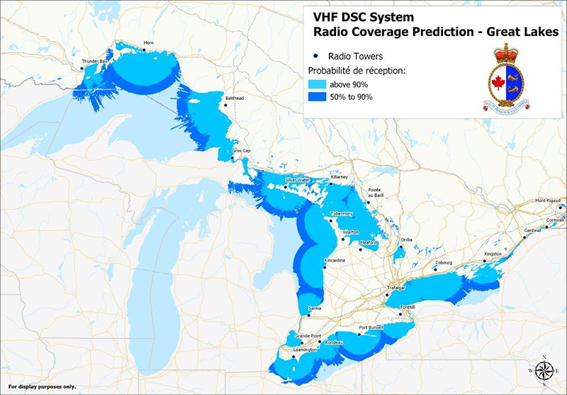
Figure 4-5 Radio Coverage Prediction Great Lakes - Text version
This map is an extension of the previous map. It illustrates the radio coverage prediction of the VHF DSC System on a map that covers the Great Lakes. It represents the A1 area, as defined in the Global Maritime Distress and Safety System. Two shades of green are used to represent the VHF DSC coverage. Light green represents 50-90% reception probability of the VHF DSC signal, whereas dark green represents over a 90% reception probability of the VHF DSC signal, as specified in the legend in the white rectangle in the lower left-hand corner of the map. The Prescott (in red) and Sarnia (in blue) MCTS Centres and remotely controlled VHF DSC-equipped sites are indicated on the map in colours corresponding to their respective centres. The Prescott MCTS Centre is the centre for the Cornwall, Cardinal, Kingston, Cobourg, Trafalgar, Fonthill and Orillia sites; the Sarnia MCTS Centre is the centre for the Sarnia, Kincardine, Leamington, Port Burwell, Grande Pointe, Rondeau, Thunder Bay, Horn, Bald Head, Sault Ste. Marie, Silver Water, Wiarton, Meaford, Tobermory, Killarney, and Pointe au Baril sites. The titles of the map in English and French, as well as the Canadian Coast Guard logo, are found in the white rectangle in the upper righthand corner. It also indicates the scale of the map. A compass card indicates North on the map. Canada and the Unites States are indicated in their respective territories.
Figure 4-6 - Radio Coverage Prediction - Pacific Ocean
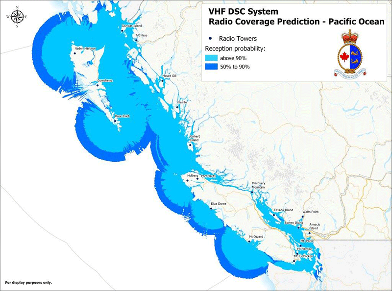
Figure 4-6 Radio Coverage Prediction Pacific Ocean - Text version
This map illustrates Western Canada which has been identified as Sea Area A1. Sea Area A1 is an area within the radiotelephone coverage of at least one very high frequency (VHF) coast station in which Digital Selective Calling (DSC) alerting is available. This map shows the radio coverage prediction of the VHF DSC system. It encompasses those waters within 40 nautical miles of the West Coast of Canada, from as far north as the Alaska/Canada Border (54°40’N) to the Washington/Canada border in Juan de Fuca and Haro Straits, including those bays, inlets, and waterways that have unobstructed signal paths from VHF radio facilities throughout the BC Coast.
The map shows every communication site equipped with VHF DSC for the MCTS centres Prince Rupert and Victoria. Areas of reception probability are indicated by two colours. Dark blue indicates reception probability of 50 to 90%. A lighter blue indicates reception probability of above 90%. Reception probability is at 90% or above for an area of up to approximately 35 nautical miles from each site indicated. For up to another 15 nautical miles from there, reception probability is indicated at between 50 to 90%.
4.2.1.8 Canadian Coast Guard Marine Communications and Traffic Services Centres (MCTS)
To help ease the transition to GMDSS and bridge the communication gap between the two systems, Canadian Coast Guard MCTS Centres will continue to monitor the current distress and safety channels VHF Ch16 and MF 2182 kHz for the foreseeable future. Once Canada’s sea areas have all been implemented, lower cost DSC equipment is available, and it is determined that these services are no longer required, these listening watches may be discontinued. This decision will be evaluated at that time.
The CCG national VHF-DSC (digital selective calling) network controlled by MCTS Centres can process VHF-DSC “Test Calls” from vessels provided that the marine radio meets the International Telecommunications Union (ITU) standard Recommendation M.493-14 (as amended) “Digital selective-calling system for use in the maritime mobile service.”
The CCG VHF-DSC equipment is configured to automatically acknowledge VHF-DSC test calls within seconds of receipt provided that the MCTS Centre VHF-DSC equipment is not processing higher priority DSC calls.
To supplement the broadcasting of Maritime Safety Information (MSI) on NAVTEX, Inmarsat SafetyNET/SafetyNET II, Iridium SafetyCast and HF NBDP, MCTS Centres will continue MSI broadcasts using the existing VHF continuous marine broadcast system and MF radiotelephony broadcast at advertised times.
4.2.2 Long-Range Identification and Tracking of Vessels Regulations (LRIT)Footnote 3
INTERPRETATION
Definitions
1. (1) The following definitions apply in these Regulations.
- "cargo vessel"
- means a vessel that is not a passenger vessel and is of 300 tons gross tonnage or more. (bâtiment de charge)
- "international voyage"
- means a voyage between a port in one country and a port in another country, but does not include a voyage solely on the Great Lakes, the St. Lawrence River and their connecting and tributary waters as far east as the lower exit of the St. Lambert Lock at Montréal. (voyage international)
- "LRIT equipment"
- means information-transmitting equipment for the long-range identification and tracking of a vessel. (équipement LRIT)
- "LRIT information"
- means the information referred to in section 5. (renseignements LRIT)
- "Minister"
- means the Minister of Transport. (ministre)
- "passenger vessel"
- means a vessel that carries more than 12 passengers. (bâtiment à passagers)
- "sea area A1, sea area A2, sea area A3 and sea area A4"
- have the meanings assigned by regulation 2.1 of Chapter IV of SOLAS. (zone océanique A1, zone océanique A2, zone océanique A3 et zone océanique A4)
- "SOLAS"
- means the International Convention for the Safety of Life at Sea, 1974, and the Protocol of 1988 relating to the Convention, as amended from time to time. (SOLAS)
When vessel is constructed
(2) For the purpose of these Regulations, a vessel is constructed on the earliest of
- the day on which its keel is laid,
- the day on which construction identifiable with a specific vessel begins, and
- the day on which assembly of the vessel reaches the lesser of 50 tonnes and 1% of the estimated mass of all structural material.
Application
Cargo vessels and passenger vessels
2. (1) These Regulations apply in respect of Canadian vessels everywhere if they
- are engaged on international voyages; and
- are cargo vessels or passenger vessels.
Exceptions
(2) These Regulations do not apply in respect of
- pleasure craft; or
- government vessels.
Compliance
Authorized representative
3. The authorized representative of a vessel shall ensure that the requirements of sections 4 to 10 are met.
LRIT Equipment
Vessels to be fitted
4. (1) Every vessel shall be fitted with LRIT equipment.
Exception — sea area A1
(2) Subsection (1) does not apply in respect of a vessel that operates exclusively in sea area A1 if it is fitted with an automatic identification system that meets the requirements of section 118 of the Navigation Safety Regulations, 2020 and is operated in accordance with that section.
Automatic transmission
5. The LRIT equipment fitted on a vessel to meet the requirements of section 4 shall automatically transmit the following information:
- the vessel’s identity;
- the vessel’s position, particularly its latitude and longitude; and
- the date and time of the transmission.
Type approval or certification
6. (1) The LRIT equipment fitted on a vessel to meet the requirements of section 4 shall be type-approved or certified by the Minister as meeting the performance standards and functional requirements set out in section 4 of the Revised performance standards and functional requirements for the long-range identification and tracking of ships, the annex to International Maritime Organization Resolution MSC.263(84), as amended from time to time.
Interpretation
(2) For the purpose of interpreting section 4 of the annex referred to in subsection (1),
- ”should” shall be read to mean “shall”; and
- ”Administration” shall be read to mean “Minister”.
Switching off equipment
7. (1) The LRIT equipment fitted on a vessel to meet the requirements of section 4 shall be capable of being switched off on board.
Master
(2) The vessel’s master may switch off the LRIT equipment
- when international agreements, rules or standards provide for the protection of navigational information; and
- in exceptional circumstances and for the shortest duration possible when the equipment’s operation is considered by the vessel’s master to compromise the safety or security of the vessel.
Informing authorities
(3) If the master switches off the LRIT equipment in the case provided for by paragraph (2) (b), the master shall
- without delay inform a Marine Communications and Traffic Services Centre of the Canadian Coast Guard and, if the vessel is in the waters of a contracting government, the relevant maritime authority of that government; and
- make an entry, in the record of navigational activities and events maintained under section 138 of the Navigation Safety Regulations, 2020, setting out the reasons for the decision and indicating the period during which the equipment was switched off.
Reducing frequency of or temporarily stopping transmission
8. (1) The LRIT equipment fitted on a vessel to meet the requirements of section 4 shall be capable of
- being configured to transmit the LRIT information at a reduced frequency of once every 24 hours; and
- temporarily stopping the transmission of LRIT information.
Master
(2) While a vessel is undergoing repairs, modifications or conversions in dry dock or in port or is laid up, the vessel’s master may, on their own initiative, and shall, if directed to do so by the Minister,
- reduce the frequency of the transmission of LRIT information to once every 24 hours; or
- temporarily stop the transmission of LRIT information.
Informing authorities
(3) If the master reduces the frequency of or temporarily stops the transmission of LRIT information under subsection (2), the master shall
- without delay inform a Marine Communications and Traffic Services Centre of the Canadian Coast Guard and, if the vessel is in the waters of a contracting government, the relevant maritime authority of that government; and
- make an entry, in the record of navigational activities and events maintained under section 138 of the Navigation Safety Regulations, 2020, indicating the period during which the transmission of LRIT information was reduced in frequency or temporarily stopped, and whether or not the Minister directed the action.
Failure of system
9. If the Minister or the Canadian Coast Guard informs the master of a vessel that any part of the system used to receive LRIT information from the vessel or to disseminate the information has failed, the master shall make an entry, in the record of navigational activities and events maintained under section 138 of the Navigation Safety Regulations, 2020, setting out the date and time the master was informed.
Electromagnetic interference
10. LRIT equipment shall be installed so that electromagnetic interference does not affect the proper functioning of navigational equipment.
Issuance of proof of type approval or of certificate
11. (1) On application, the Minister shall issue a proof of type approval or a certificate for LRIT equipment if the Minister determines that the equipment meets the performance standards and functional requirements referred to in subsection 6(1).
Carry proof or certificate on board
(2) A vessel’s master shall ensure that a proof of type approval or a certificate issued under subsection (1) for the LRIT equipment fitted on the vessel to meet the requirements of section 4 is
- in the case of a proof of type-approval, carried on board in the form of
- a label that is securely affixed to the equipment in a readily visible location, or
- a document that is kept in a readily accessible location; and
- in the case of a certificate, carried on board in a readily accessible location.
Coming into force
Registration date
12. These Regulations come into force on the day on which they are registered.
4.2.3 Emergency Position Indicating Radio Beacons (406 MHz)
It is recommended that a float-free EPIRB be carried on board ships and pleasure crafts operating offshore. To be effective, 406 MHz EPIRBs must be registered with the Canadian Beacon Registry by telephone 1-800-406-7671; facsimile 1-877-406-3298; or, on the website. You may also reach the Canadian Beacon Registry by email at cbr@sarnet.dnd.ca.
Up to date Beacon registration is mandatory under section 228 of the Navigation Safety Regulations, 2020.
- Float-free EPIRBs should not be fitted under ledges or structures that would impede their ability to float free. Do not install the EPIRB with lanyard attached to the superstructure of your vessel.
- Both manually activated EPIRBs and float-free EPIRBs should be readily accessible so that in the event of an emergency, it is available for immediate use.
- EPIRBs should be tested using the “TEST” button, by the operator every 6 months. This test should be recorded in the radio log.
- EPIRB battery packs and hydrostatic release units should be replaced per the manufacturer’s recommendations.
4.2.4 Navigation Safety Regulations, 2020
Consult Section 209 of the Regulations for more details.
| Region | 8 m in Length | 8 m to 12 m in Length | More than 12 m in Length |
|---|---|---|---|
| Near Coastal I and beyond | Float Free EPIRB | Float Free EPIRB | Float Free EPIRB |
| Near Coastal II | Float Free EPIRB Manual EPIRB 406 MHz PLB; or Portable VHF w/ DSC* |
Float Free EPIRB Manual EPIRB; or 406 MHz PLB |
Float Free EPIRB |
4.2.5 Guidance for Masters in Distress Situations and Alerting of SAR Authorities
In 1992, the International Maritime Organization (IMO) prepared a flow chart providing GMDSS operating guidance for masters of ships in distress situations (COM/Circ.108). It was recommended that this chart be displayed on the ship's bridge.
Later, another circular (MSC/Circ.892) was prepared to strongly emphasize the importance for ships to alert SAR authorities at the earliest possible moment in any situation that may involve a danger to life or that has the potential of developing into such a situation.
The following is for the mariner’s information and guidance:
- GMDSS Operating Guidance for Masters of Ships in Distress Situations and;
- Alerting the Search and Rescue Authorities
| VHF | Digital Selective Calling (DSC) Channel 70 | Radiotelephone Channel 16 | Radiotelex |
|---|---|---|---|
| MF | 2187.5 kHz | 2182 kHz | 2174 kHz |
| HF4 | 4207.5 kHz | 4125 kHz | 4177.5 kHz |
| HF6 | 6312 kHz | 6215 kHz | 6268 kHz |
| HF8 | 8414.5 kHz | 8291 kHz | 8376.5 kHz |
| HF12 | 12577 kHz | 12290 kHz | 12520 kHz |
| HF16 | 16804.5 kHz | 16420 kHz | 16695 kHz |
4.2.5.1 Alerting the Search and Rescue Authorities (MSC/Circ.892)
- The need for the earliest possible alerting of the search and rescue (SAR) co-ordination authority to maritime emergencies cannot be over-emphasized.
- It is essential to enable shore-based facilities to respond without delay to any situation which constitutes, or has the potential to constitute, a danger to life. Time lost in the initial stages of an incident may be crucial to its eventual outcome. It cannot be regained.
- Factors to be considered include position (in relation to hazards and to shore-based or other SAR units); time of day; weather conditions (actual and forecast); the number of persons at risk or potentially at risk; specific assistance required, etc.
- It is always best to consider the "worst-case scenario" and to alert the SAR organization accordingly. Depending on the circumstances, the co-ordinating authority may choose to alert or dispatch SAR facilities as a precautionary measure and/or to reduce transit times. If assistance is not subsequently required, any such positive response can be easily curtailed. But time lost through delays in notification can never be regained.
- It is therefore essential that the SAR co-ordinating authority be informed immediately of:
- all maritime SAR incidents;
- any situation which may develop into a SAR incident; and
- any incident which may involve or lead to danger to life, the environment or to property which may require action from the SAR services and/or other authorities.
Operating guidance for masters of ships in distress or urgency situations [to be considered in conjunction with IMO publication 969 - GMDSS Operating Guidance for Masters of Ships in Distress Situations (COM/Circ.108 of 23 January 1992)]
- The following diagram shows standard procedures for distress/urgency message routing. It is for guidance only, and does not preclude the use of any and all available means of distress alerting.
Figure 4-7 - Operating Guidance for Masters of Ships in Distress or Urgency Situations
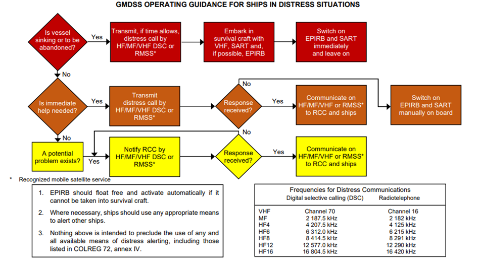
Figure 4-7 operating guidance for masters of ships in distress or urgency situations - Text version
Flow chart of operating guidance for masters of ships in distress or urgency situations
This diagram is used to guide masters of ships in distress or emergency situations. The diagram is made up of rectangular-shaped boxes in which are described situations and actions. Depending on the vessel's situation (abandonment, immediate assistance required or potential problem), the officer uses the arrows to navigate through the boxes that correspond to the appropriate actions.
First situation: Must vessel be abandoned?
If YES:
- Send distress call
- Board survival craft with VHF, EPIRB and/or SART, if possible
- Activate EPIRB and SART immediately
If NO: we proceed to the next situation
Second situation: Is immediate help required?
If YES:
- Send distress call
If a response is received:
- Communicate with JRCC and Search and Rescue Units (SRUs)
If no response is received:
- Activate EPIRB and SART immediately
If NO, immediate help is not required: we proceed to the next situation.
Third and final situation: A potential problem exists
- Notify JRCC until a response is received
When a response is received:
- Communicate with JRCC and SRUs.
Operation guidance for masters of ships observing another vessel apparently in danger
- The following diagram shows suggested procedures for reporting concerns about the safety of another vessel (fire, smoke, adrift, navigating towards a danger, etc.).
Figure 4-8 - Operation Guidance for Masters of Ships Observing Another Vessel Apparently in Danger
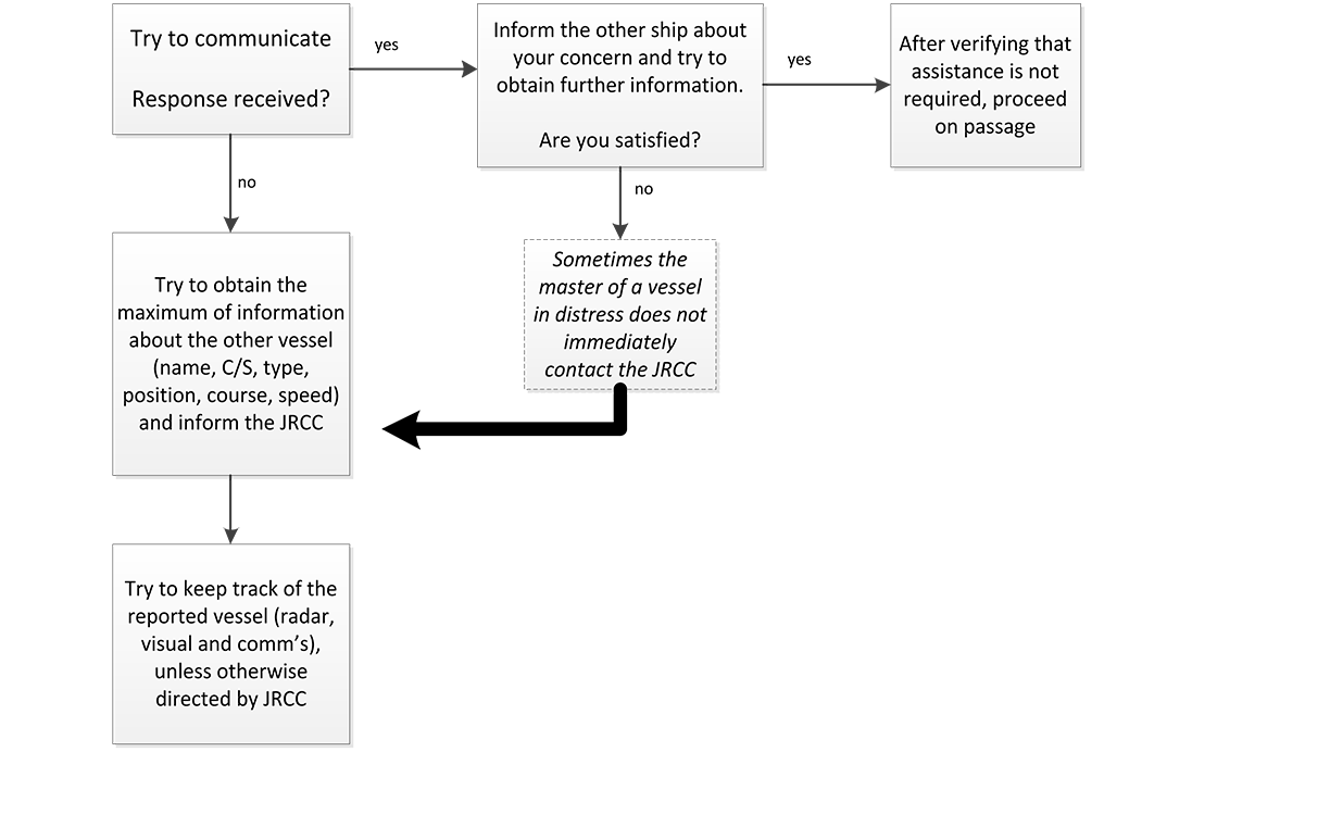
Figure 4-8 Operating guidance for masters of ships observing another vessel apparently in danger - Text version
Flow chart of operating guidance for masters of ships observing another vessel apparently in danger
This is a diagram used to guide masters of ships observing another vessel apparently in danger. The diagram is made up of rectangular-shaped boxes corresponding to actions. Depending on whether the answer to a situation is YES or NO, the officer uses the arrows to navigate through the boxes corresponding to the appropriate actions to take in order to assist, if necessary.
Try to communicate with the ship that seems in distress.
If a response is received:
Inform the other ship about your concern and try to obtain further information.
Are you satisfied?
If YES: After verifying that assistance is not required, proceed on passage.
Are you not satisfied?
Sometimes the master of a vessel in distress does not immediately contact the JRCC. In such case:
- Try to obtain the maximum of information about the other vessel (name, C/S, type, position, course, speed and inform the JRCC.
If a response is not received:
- Try to obtain the maximum of information about the other vessel (name, C/S, type, position, course, speed and inform the JRCC.
- Try to keep track of the reported vessel (radar, visual and comm's) unless otherwise directed by JRCC.
Note: For local JRCC or MRSC contact information, refer to section Section 4.3.7 Search and Rescue in Canadian Areas of Responsibility (Part 4 of this publication)
4.2.5.2 False Distress Alerts and Distress Relay Alerts
The GMDSS has been in force for ships on international voyages since February 1, 1999, following its seven-year phase-in. During this time, considerable experience was gained internationally in the operation of the GMDSS. While the GMDSS has proven its overall effectiveness, the high number of accidental distress alert activations and the inappropriate and unintended Digital Selective Calling (DSC) distress relay alerts have detracted from the efficiency of the system. Excessive false alerts and distress relay alerts can create an unnecessary burden and workload for SAR services. They may also cause confusion and undermine mariners’ confidence in the GMDSS. They could potentially have a serious impact on real distress situations.
With the aim of minimizing the number of false alerts and distress alert relays, the following information is provided:
- “Instructions for Mariners and Others on How to Cancel a False Alert” (appendix to IMO Resolution A.814(19) entitled Guidelines for the Avoidance of False Distress Alerts).
- “Procedure for Responding to DSC Distress Alerts by Ships” (COMSAR/Circ.25).
4.2.5.3 Instructions for Mariners and OthersFootnote 4 on How to Cancel a False Distress AlertFootnote 5
[Appendix to IMO Resolution A.814 (19)]
DSC
- VHF
- switch off transmitter immediatelyFootnote 6
- switch equipment on and set to Channel 16; and
- make broadcast to “All Stations” giving the ship’s name, call sign and MMSI number, and cancel the false distress alert.
Example
All Stations, All Stations, All Stations
This is NAME, CALL SIGN
MMSI NUMBER, POSITIONCancel my distress alert of
DATE, TIME, UTC
= Master NAME, CALL SIGN,
MMSI NUMBER, DATE, TIME UTC - MF
- switch off equipment immediatelyFootnote 7
- switch equipment on and tune for radiotelephony transmission on 2182 kHz; and
- make broadcast to “All Stations” giving the ship’s name, call sign and MMSI number, and cancel the false distress alert.
Example
All Stations, All Stations, All Stations
This is NAME, CALL SIGN
MMSI NUMBER, POSITION.Cancel my distress alert of
DATE, TIME, UTC,
= Master NAME, CALL SIGN,
MMSI NUMBER DATE, TIME UTC. - HF
As for MF, but the alert must be cancelled on all the frequency bands on which it was transmitted. Hence, in stage 2.2 the transmitter should be tuned consecutively to the radiotelephony distress frequencies in the 4, 6, 8, 12 and 16 MHz bands, as necessary.
- Inmarsat-C
Notify the appropriate JRCC/MRSC to cancel the alert by sending a distress priority message via the same CES through which the false distress alert was sent.
Example
NAME, CALL SIGN, IDENTITY NUMBER,
POSITION
Cancel my Inmarsat-C distress
alert of DATE, TIME UTC
= Master + - EPIRBs
If for any reason an EPIRB is activated accidentally, the ship should contact the nearest coast station or an appropriate coast earth station or JRCC/MRSC and cancel the distress alert.
- General
- 6.1 Notwithstanding the above, ships may use any means available to them to inform the appropriate authorities that a false distress alert has been transmitted and should be cancelled.
- 6.2 No action will normally be taken against any ship or mariner for reporting and cancelling a false distress alert. However, in view of the serious consequences of false alerts, and the strict ban on their transmission, Governments may prosecute in cases of repeated violations.
4.2.6 Procedure for Responding to DSC Distress Alerts by Ships
(MSC.1/Circ.1657)
- The Maritime Safety Committee, at its 106th session (2 to 11 November 2022), approved the revised Procedure for responding to DSC distress alerts by ships, as set out in the annex, prepared by the Sub-Committee on Navigation, Communications and Search and Rescue (NCSR), at its ninth session (21 to 30 June 2022).
- This circular contains a procedure to be followed by radio personnel on board ships when responding to VHF, MF and HF distress alerts, in accordance with chapter IV of the International Convention for the Safety of Life at Sea, 1974. Flow diagrams 1 and 2 in the annex are recommended to be displayed on ships' bridges as A4 size posters.
- Member Governments are invited to bring the annexed Procedure to the attention of seafarers and all other parties concerned.
- This circular becomes effective on 1 January 2024, superseding COMSAR/Circ.25 as from that date.
1. Introduction
This document provides a procedure for responding to VHF, MF and HF distress alerts, given in flow diagrams 1 and 2, which are recommended to be displayed on the ship's bridge as A4 size posters. It also provides the following guidance.
2. Distress relays
- 2.1 Radio personnel serving on ships should be made aware of the consequences of transmitting a distress call relay and of routeing a DSC distress alert relay to destinations other than coast stations (CS).
- 2.2 The number of unintended activations of DSC distress alerts and DSC distress alert relays creates extra workload and confusion for (M)RCCs and also causes delay in the response-time. The original distress alert from a ship in distress should not be disrupted by other ships, by transmitting a DSC distress alert relay.
- 2.3 Recommendation ITU-R M.541 on Operational procedures for the use of digital selective-calling equipment in the maritime mobile service identifies only two situations in which a ship would transmit a distress call relay (distress alert relay):
- on receiving a distress alert on an HF channel, which is not acknowledged by a coast station within five minutes. The distress call relay should be addressed to the appropriate coast station (annex 1, paragraph 3.4.2 and annex 3, paragraph 6.1.4); and
- on knowing that another ship in distress is not itself able to transmit the distress alert and the master of the ship considers that further help is necessary. The distress call relay should be addressed to "all ships" or to the appropriate coast station (annex 3, paragraph 1.4).
- 2.4 In no case is a ship permitted to transmit a DSC distress alert relay on receipt of a DSC distress alert on either VHF or MF channels.
- 2.5 Distress calls relay on HF channels should be initiated manually.
- 2.6 Compliance with operational and technical provisions above would prevent transmissions of inappropriate distress calls relay.
3. All coast stations call
- 3.1 Recommendation ITU-R M.493-9 on Digital selective-calling systems for use in the maritime mobile service provides for "group calls" a address consisting of the characters corresponding to the station's Maritime Mobile Service identity (MMSI) and a number of administrations have already assigned a "group call" MMSI to their coast stations in addition to the coast station's individual MMSI.
- 3.2 By multilateral agreements, a "group call" MMSI could be assigned to all coast stations of a specific region, e.g., a JRCC area and could comply with IMO's requirement without need of introducing further modifications to GMDSS equipment.
- 3.3 An alternative method to implement an "all coast stations" call without the need to modify Recommendation ITU-R M.493 could be to use the reserved MMSI worldwide as an address for all coast stations, in accordance with Recommendation ITU-R M.585 on Assignment and use of identities in the maritime mobile service. However, this solution is not applicable to MF or HF coast stations and would also require a modification of the set-up at each VHF coast station participating in the GMDSS.
4. Authorization
It should be noted that on ships, distress alerts, distress acknowledgements and distress relay calls can only be transmitted with permission of the Master of the ship.
5. Flow diagrams
- 5.1 The simplified flow diagrams 1 and 2 describe actions to be taken aboard ships upon receipt of distress alerts from other ships. Administrations distribute these flow diagrams to ships and training institutions.
- 5.2 Member Governments are invited to bring the above guidance and the attached flow diagrams to the attention of their shipowners, seafarers, coast stations, JRCCs/MRSCs and all others concerned.
Figure 4-9 - Flow Diagram 1
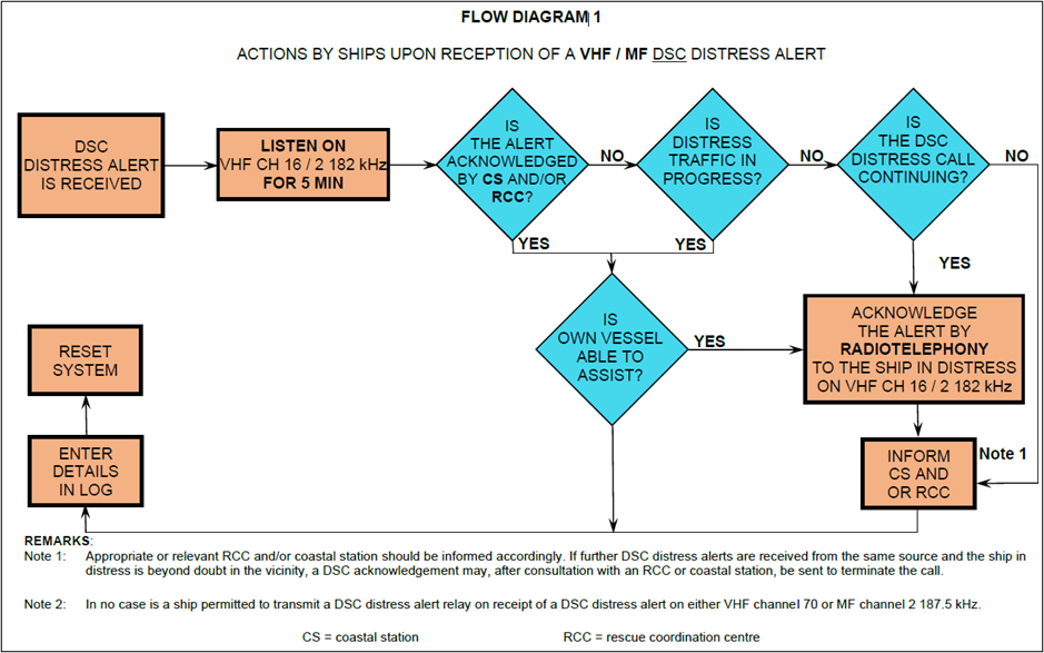
Figure 4-9 Flow diagram 1 COMSAR/Circ.25 - Text version
Flow diagram for actions by ships upon reception of VHF/MF DSC Distress Alert
This diagram outlines the actions to be taken by ships upon reception of an HF-DSC Distress Alert. A series of nine blocks connected by arrows, in a rectagular shaped layout, outlines next steps.
(Block 1) advises ‘HF DSC Distress alert’. An arrow leads to the right to the next block (Block 2) which advises ‘Listen on associated RTF or NBDP Channel(s) for 5 minutes. An arrow on the right side of this block points to a diamond shaped block (Block 3) which asks ‘Is the alert acknowledged or relayed by Coast Station (CS) or Joint Rescue Coordination Centre (JRCC)?’ If the answer is ‘NO’ an arrow points to another diamond shaped block (Block 4) which asks ‘Is distress communication in progress on associated RTF channels?’ if the answer is ‘NO” an arrow points to a rectangular shaped block (Block 5) which advises ‘Transmit distress relay on HF to coast station and inform JRCC’. If the answer to the question in blocks 3 and 4 was ‘YES’ an arrow directs you to a diamond shaped block directly below (Block 6) which asks ‘Is own vessel able to assist?’ If the answer is ‘YES’ an arrow points to a block to the right (Block 7) which advises ‘Contact JRCC via most efficient medium to offer assistance.’ If the answer to the question in Block 6 ‘Is own vessel able to assist?’ is ‘NO’ an arrow points down then to the left then 90 degrees up to a small square (Block 8) which advises ‘Enter details in log’. An arrow from the top of this block points up to another small block (Block 9) which advises ‘Reset system’.
Notes:
Note 1: Appropriate or relevant JRCC/MRSC and/or Coast Station shall be informed accordingly. If further DSC distress alerts are received from the same source and the ship in distress is behond doubt in the vicinity, a DSC acknowledgement may, after consultation with a JRCC/MRSC or Coast Station, be sent to terminate the call.
Note 2: In no case is a ship permitted to transmit a DSC distress relay call on receipt of a DSC distress alert on either VHF channel 70 or MF Channel 2187.5 kHz.
Figure 4-10 - Flow Diagram 2
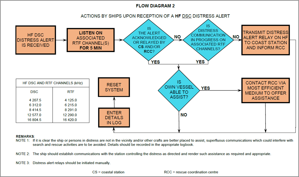
Figure 4-10 Flow diagram 2 (COMSAR/Circ.25) - Text version
Actions by ships upon reception of HF-DSC distress alert
This diagram outlines the actions to be taken by ships upon reception of an HF-DSC Distress Alert. A series of nine blocks connected by arrows, in a rectagular shaped layout, outlines next steps.
(Block 1) advises ‘HF DSC Distress alert’. An arrow leads to the right to the next block (Block 2) which advises ‘Listen on associated RTF or NBDP Channel(s) for 5 minutes. An arrow on the right side of this block points to a diamond shaped block (Block 3) which asks ‘Is the alert acknowledged or relayed by Coast Station (CS) or Joint Rescue Coordination Centre (JRCC)?’ If the answer is ‘NO’ an arrow points to another diamond shaped block (Block 4) which asks ‘Is distress communication in progress on associated RTF channels?’ if the answer is ‘NO” an arrow points to a rectangular shaped block (Block 5) which advises ‘Transmit distress relay on HF to coast station and inform JRCC’. If the answer to the question in blocks 3 and 4 was ‘YES’ an arrow directs you to a diamond shaped block directly below (Block 6) which asks ‘Is own vessel able to assist?’ If the answer is ‘YES’ an arrow points to a block to the right (Block 7) which advises ‘Contact JRCC via most efficient medium to offer assistance.’ If the answer to the question in Block 6 ‘Is own vessel able to assist?’ is ‘NO’ an arrow points down then to the left then 90 degrees up to a small square (Block 8) which advises ‘Enter details in log’. An arrow from the top of this block points up to another small block (Block 9) which advises ‘Reset system’.
Notes:
Note 1: If it is clear the ship or persons in distress are not in the vinicity and/or other crafts are better placed to assist, superfluous communications which could interfere with search and rescue activities are to be avoided. Details should be recorded in the appropriate logbook.
Note 2: The ship should establish communications with the station controlling the distress as directed and render such assistance as required and appropriate.
Note 3: Distress relay calls should be initiated manually.
4.2.7 AMVER - Automated Mutual-Assistance Vessel Rescue System
Note: A 96-hour pre-arrival report to U.S. ports is required under 33 CFR 160.
The Amver System, operated by the United States Coast Guard, is a maritime mutual assistance program that provides important aid to the development and co-ordination of search and rescue (SAR) efforts in the oceans of the world. Merchant vessels of all nations making offshore passages of more than 24 hours are encouraged to send sailing plans and periodic position reports to the Amver Centre in Martinsburg, WV. There is no charge for these radio messages when they are sent through MCTS Centres. Information from these messages is entered into a computer that generates and maintains dead reckoning positions for participating vessels throughout their voyages. The predicted locations and SAR characteristics of all vessels known to be within a given area are furnished upon request to recognized SAR agencies of any nation for use during an emergency. Predicted vessels’ locations are disclosed only for reasons related to maritime safety.
Amver is a free and voluntary program. An Amver participant is under no greater obligation to render assistance during an emergency than a vessel that is not participating. Benefits to shipping include:
- improved likelihood of rapid aid in emergencies;
- reduced number of calls for assistance to vessels not favourably located; and
- reduced time lost for vessels responding to calls for assistance. An Amver participant is under no greater obligation to render assistance during an emergency than a vessel that is not participating.
Details of Amver System operations may be obtained from Amver Maritime Relations Office, U.S. Coast Guard, Battery Park Building, 1 South Street, New York, NY 10004-1499 (Telephone: 212-668-7764, Fax 212-668-7684). Amver instructions are also available at Coast Guard Captain of the Port and Marine Safety Offices in major United States coastal ports. The instructions are published in the following languages: Chinese, Danish, Dutch, English, French, German, Greek, Italian, Japanese, Norwegian, Polish, Portuguese, Spanish, and Swedish. Requests for instructions should state the language desired if other than English. Consult the Amver website.
4.2.7.1 To Participate
Any merchant vessel of one thousand gross tons or more on a voyage of greater than twenty-four hours to anywhere on the globe is to be part of the Amver system. International participation is voluntary regardless of vessel’s or company’s flag, country of origin, or destination.
4.2.7.2 The Information Reported
Information voluntarily provided by vessels to Amver is kept strictly confidential and is protected by the Coast Guard (USA). It will be released only for safety purposes.
4.2.7.3 What and When You Report
- Sailing plan message should be sent on or before departure.
- Position Reports should be sent within twenty-four hours of departure and subsequently no less frequently than every forty-eight hours until arrival.
- Arrival Reports should be sent immediately prior to or upon arrival at the Port of Destination.
- Reports are to be sent during the Radio Officer’s normal duty hours.
- At the discretion of the vessel, reports may be sent more frequently than the above schedule, as, for example, in heavy weather or under other adverse conditions.
4.2.7.4 Report Format
As previous Amver participants will note, the format described below represents a change which serves two purposes: First, the new format will permit the automated data processing system to enter your information into Amver more accurately and efficiently. Second, the new format conforms to the International Maritime Organization (IMO) proposed standard, thus reducing the number of different formats in use. As other systems also adopt the IMO format, we will have moved closer to a single format worldwide.
4.2.7.5 Amver System Communications Network
The following methods are recommended for ships to transmit Amver Sailing Plan, Position, Deviation and Arrival reports. Details are available on the Amver website.
Via email: amvermsg@amver.com
AMVER/SEAS “Compressed Message” via Inmarsat-C via TELENOR: Amver address: NOAA telephone number entered in the ADDRESSBOOK. For information, please see the instruction sheet for your brand of Inmarsat-C transceiver. AMVER/SEAS software can be downloaded from the Internet or requested from:
TELENOR Satellite Services
1101, Wootton Parkway
Rockville, Maryland 20852
1-301-838-7800
Email: customercare@telenor.com
HF Radiotelex Service of U.S. Coast Guard Communications Stations: Full information on how to send Amver messages this way can be found online.
HF Radio at no cost via Coast Guard Contractual Agreements with the following companies:
- Mobile Marine Radio (WLO)
- Mobile (WCL)
- Marina Del Ray (KNN)
- Seattle (KLB)
Telex: Amver Address: (0) 230 127594 AMVERNYK
Telefax: To the USCG Operations Systems Centre in Martinsburg: 1-304-264-2505
If messages are relayed through CCG Ships no ship charge will be assessed. All Amver messages forwarded via the stations listed should be addressed to Amver Halifax or Amver Vancouver, rather than COAST GUARD New York, to ensure that no charge is applied in delivery.
4.2.7.6 Amver Voyage Report Types
There are four types of Amver Reports - Sailing Plan, Arrival, Position, and Deviation Reports.
- Reporting format. Each line of Amver Report text starts with a line identifier. Line identifiers are “AMVER” or a single letter. The line identifier and the data items on the line are each separated from each other by a single slash (“/”). Lines are terminated by two slashes (“//”).
- Reporting data. Amver participants need to be familiar with four types of reports - Sailing Plan, Arrival, Position, and Deviation Reports. Note that Amver permits sailing plan and departure to be combined into a single report. Amver accepts sailing plan information separately - for example, several days prior to departure. Report identifiers are as follows:
- AMVER/SP// Sailing Plan and Departure
- AMVER/PR// Position Report
- AMVER/FR// Final Arrival Report.
- AMVER/DR// Deviation Report.
- Details. Paragraph IX includes a discussion of each report type. Each example is followed by an explanation. Note that not all the lines in the example are necessary for each type of report. The required and optional lines are discussed in each section.
4.2.7.7 Other Required Information
Amver also needs other information, which might be useful in an emergency. This includes data such as the ship length, communications equipment, radio watch schedule, speed, rig, and so forth. This information is collected separately once, by completion of the Search and Rescue Questionnaire (SAR-Q) found on the Amver website which is then retained in the automatic data processing system, periodically validated, and used only for search-and-rescue purposes.
4.2.7.8 Release of Information
All voluntary information collected under these instructions will only be released to recognized search-and-rescue authorities. Information regarding vessels required to participate in Amver will be forwarded to the U.S. Maritime Administration, via the keyword MAREP on the Y-Line.
4.2.7.9 Description of Voyage Reports
An example and explanation of each of the four types of Amver reports follows. Letters in parentheses refer to the notes at the end of the section.
Sailing Plan and Departure Report. The “L” lines contain routing and “turnpoint” information needed by Amver. Amver needs data about every intended turnpoint, but also accepts information about any points along the intended track, even though they might not be turnpoints. Turnpoint information is needed by Amver to maintain plot accuracy.
Table 4-8 - Sailing Plan and Departure Report Example
Example
AMVER/SP//
A/SANDY JOAN/ABCD//
B/110935Z//
E/145//
F/126//
G/NORVOROSK/4510N/03820E//
I/GIBRALTERGI/3600N/00600W/140730Z//
L/RL/140/4130N/02910E/112000Z//
L/RL/140/4010N/02620E/112300Z//
L/RL/140/3630N/02330E/120330Z//
L/RL/140/3650N/01520E/121500Z//
L/RL/140/3800N/01000E/130100Z//
L/LR/060//
M/GKA/INMARSAT 871 987654321//
V/MD/NURSE//
X/NEXT/REPORT/120900Z//
Z/SITOR/INSTALLED/SELCALL/NUMBER/IS/99999//
Z/EOR//
Explanation
RequiredAMVER/SP//
A /vessel name/International Radio Call Sign//
B /intended time of departure or departure time// a
G /port of departure/latitude/longitude// b
I /port of destination/latitude/longitude/estimated time of arrival// abc
L /...... route information ...//acd
Z /end of report//
E /current course// e
F /estimated average speed// f
M /current coastal radio station/next coastal radio station, if any//
V /onboard medical resources// g
X /up to 65 characters of amplifying comments// hi
Table 4-9 - Final Arrival Report Example
Example
AMVER/FR//
A/SANDY JOAN/ABCD//
K/NEW YORK/US/4040N/07420W/180600Z//
X/PROBLEMS WITH MF XMTR AGENT/ADVISED//
Z/EOR//
Table 4-10 - Position Report Example
Example
AMVER/PR//
A/SANDY JOAN/ABCD//
B/120300Z//
C/3630N/02330E//
E/145//
F/126//
M/GKM/INMARSAT 871 987654321//
X/NEXTREPORT/131800Z//
Z/EOR//
Explanation
RequiredAMVER/PR//
A /vessel name/International Radio Call Sign//
B /time at position// a
C /latitude/longitude// c
Z /end of report//
E /current course// e
F /average speed// f
M /information on the best way to contact the vessel quickly in the event of a distress at sea (coast radio station call signs, ship’s INMARSAT number, etc.)//
X /up to 65 characters of amplifying comments// hi
Table 4-11 - Deviation Report Used to Report Sailing Plan and Other Changes Example
Example
AMVER/DR//
A/SANDY JOAN/ABCD//
B/120300Z//
E/095//
F/220//
G/NORVOROSK/4470N/03780E//
I/NEW YORK US/4040N/07420W/180800Z//
L/GC/220//
M/GKA/WSL/INMARSAT 871 987654321//
V/MD/NURSE//
X/DIVERTING BEST SPEED TO NEW YORK US//
Z/EOR//
Explanation
RequiredAMVER/DR//
A /vessel name/International Radio Call Sign//
Z /end of report//
One or more of the following optional items
B /intended time of departure// a
E /intended course// e
F /intended average speed// f
G /port of departure/latitude/longitude// b
I /port of destination/latitude/longitude/estimated time of arrival// abc
L /……route information ....// acd
M /information on the best way to contact the vessel quickly in the event of a distress at sea (coast radio station call signs, ship’s INMARSAT number, etc.)//
V /onboard medical resources// g
X /up to 65 characters of amplifying comments// hi
4.2.8 Pre-Arrival Information Report (PAIR)
Note: Pursuant to the Marine Transportation Security Regulations (MTSR), the Security Measures Respecting Designated Tall Ship Events and the Security Measures Respecting Tall Ships and Marine Facilities that Interface with Tall Ships; vessels entering Canadian waters are required to submit pre-arrival information to Transport Canada. However please note that the following pre-arrival information requirement does not apply to fishing vessels, pleasure craft, government vessels, nor to vessels operating solely on the Great Lakes or to the portions of a vessel’s voyage on the Great Lakes after pre-arrival information has been given prior to its entrance into the St. Lawrence Seaway.
Requirement:
The master of the following vessels (including tall ships), engaged on an international voyage:
- SOLAS vessels of 500 tons gross tonnage or more;
- SOLAS and NON-SOLAS vessels carrying 12 passengers or more;
- NON-SOLAS vessels that are more than 100 tons, gross tonnage; and
- NON-SOLAS vessels that are a towing vessel engaged in towing a barge astern or alongside or pushing ahead, if the barge is carrying certain dangerous cargoes;
shall ensure the vessel does not enter Canadian waters until they submit their 96 hour pre-arrival information to Transport Canada:
- at least 96 hours prior to entering Canadian Waters
- if the duration of the segment of the voyage before entering Canadian waters is less than 96 hours but more than 24 hours, at least 24 hours before entering Canadian waters; or
- if the duration of the segment of the voyage before entering Canadian waters is less than 24 hours, as soon as practicable before entering Canadian waters but no later than the time of departure from the last port of call.
Transport Canada requests the pre-arrival information report (PAIR) be submitted using the 96-Hour PAIR PDF form. Forms can be obtained by emailing:
- 96@tc.gc.ca or tc.pair-npa.tc@tc.gc.ca – to receive an English PAIR Form
- tc.npa-pair.tc@tc.gc.ca – to receive a French PAIR Form
The 96hr PAIR report is not to be confused with the 24hr reporting requirements for the Canadian Coast Guard Vessel Traffic Services as noted in Section 3.7 of this document.
Once an email is sent, an attached .PDF form will automatically be forwarded to the requestor. Forms can be saved and emailed to Transport Canada according to one of the following:
Vessels entering WESTERN CANADA
Transport Canada Marine Security Operations Centre West
marsecw@tc.gc.ca
1-250-363-4850
Vessels entering EASTERN CANADA, the ST. LAWRENCE SEAWAY or the CANADIAN ARCTIC
Transport Canada Marine Security Operations Centre East
marsece@tc.gc.ca
1-902-427-8003
It is the responsibility of the Master of the vessel to ensure that all information provided to the Government of Canada (Transport Canada) in the PAIR is complete and accurate. If there is any change in the pre-arrival information reported, the master shall ensure the change is reported prior to entering Canadian waters. If a change occurs after the vessel has entered Canadian waters, that the change be reported before the vessel’s first interface with a marine facility in Canada. Masters of vessels subject to the Marine Transportation Security Regulations (as described above) failing to submit, or submitting incomplete or inaccurate pre-arrival information, risk subjecting their vessel to control actions such as, but not limited to: inspection, detention, redirection or expulsion from Canadian waters. The Master may also be subject to administrative monetary penalty should regulatory requirements not be satisfied.
If the Master is unable to populate and submit the PAIR PDF form it is recommended that the Master engage the Company Security Officer or other designated person ashore to complete and submit the PAIR PDF form on their behalf. The responsibility for compliance with the PAIR submission remains with the Master.
If, for any reason, vessels are unable to send the PAIR via the above requested methods, the following contingencies should be considered:
- if unable to get a digital PDF form, see the section below for the required information
- if the email system is unserviceable, the ship may send the required information (see section below) via any Canadian Coast Guard Marine Communications and Traffic Services (MCTS) centre. Contact information for MCTS Centres may be found in Part 2 of this publication.
The vessel’s pre-arrival information shall include the following:
- its name;
- its country of registry;
- the name of its registered owner;
- the name of its operator;
- the name of its classification society (not applicable to tall ships);
- its international radio call sign;
- its International Ship Security Certificate, Canadian Vessel Security Certificate or ship security compliance document number;
- its International Maritime Organization number, if it is a SOLAS ship;
- the IMO Unique Company Identification Number of its company and the IMO Unique Registered Owner Identification Number of its owner
- the date of issuance, date of expiry and name of the issuing body of its International Ship Security Certificate, Canadian Vessel Security Certificate, or ship security document;
- confirmation that the vessel has an approved vessel security plan;
- the current MARSEC level;
- a statement of when its last 10 declarations of security were completed;
- details of any security breaches, security incidents or security threats involving the vessel during the last ten calls at marine facilities and during the time spent at sea between those calls;
- details of any deficiencies in its security equipment and systems, including the communication systems, and the way in which the master of the vessel intends to correct them;
- if applicable, the name of its agent and contact person and their 24-hour telephone and facsimile numbers (not applicable to tall ships);
- if applicable, the name of the vessel's charterer;
- its position and the date and time at which it reached that position;
- its course and speed;
- its first port of call in Canada, with the estimated time of arrival at that port of call, and, if applicable, its final destination with the estimated time of arrival at that destination;
- the name of a contact person at the marine facility that it will visit and their 24-hour telephone and facsimile numbers;
- the following information in respect of its last ten marine facilities visited:
- the receiving facility;
- the marine facility visited;
- the city and country;
- the date and time of arrival, and
- the date and time of departure;
- a general description of the cargo, including cargo amount (not applicable to tall ships);
- if applicable, the presence and description of any dangerous substances or devices on board; and
- the following contact information:
- the name of the master
- an email address, if applicable, and
- a satellite or cellular telephone number, if applicable.
Transport Canada Marine Security will confirm successful processing of the 96 hour PAIR and review of the ISSC via email once processing is completed. This email may also contain further instructions for entering Canadian waters.
Request all pages of the vessel’s Interim International Ship Security Certificate (IISSC), International Ship Security Certificate (ISSC), Interim Canadian Vessel Security Certificate (ICVSC), Canadian Vessel Security Certificate (CVSC) or Ship Security Compliance document be included with the Pre- Arrival Information Report.
For any additional questions or queries regarding pre-arrival information, please contact the appropriate Marine Security Operations Centre (East or West) via email or telephone as provided earlier in this section.
4.2.9 Reporting Marine Occurrences to Transportation Safety Board (TSB)
Pursuant to the Canadian Transportation Accident Investigation and Safety Board Act, the Transportation Safety Board Regulations require that the person responsible for the ship (e.g. owner, operator, charterer, master, pilot, crew member) in Canadian waters, or a Canadian ship in any waters, report a marine occurrence as soon as possible and by the quickest means available to TSB. The following alternatives to reporting to TSB are deemed acceptable: a Marine Communications and Traffic Services (MCTS) Centre; a marine radio station operated by the St. Lawrence Seaway Management Corporation; or, a Canadian harbour radio station.
Persons responsible for ships are reminded that penalties may be incurred by failing to report a marine occurrence. A marine occurrence shall also be reported in writing, within 30 days following the marine occurrence, by completing the “Report of a marine occurrence / hazardous occurrence report” (PDF, 552 KB) also available from the TSB website.
- Submit TSB form Report of a marine occurrence / hazardous occurrence report;
- Contact a TSB Regional Standby officer; or,
- Make general inquiries.
Atlantic Region
Telephone (24/7): 902-471-0820
Facsimile: 819-997-2239
Email: MarineNotifications.Atlantic@tbs-bst.gc.ca
Address: 150 Thorne Avenue, Dartmouth, NS B3B 1Z2
Central and Arctic Region
Telephone (24/7): 418-580-3510
Facsimile: 819-997-2239
Email: MarineNotifications.Central@tsb-bst.gc.ca
Address: 2575 Ste-Anne Blvd, Suite 220, Québec, QC G1J 0G7
Pacific Region
Telephone (24/7): 604-219-2414
Facsimile: 819-997-2239
Email: MarineNotifications.Pacific@tsb-bst.gc.ca
Address: #4-3071 Number Five Road, Richmond, BC V6X 2T4
Please note: Workplace injuries on board vessels must also be reported directly to Transport Canada.
4.3 Services
4.3.1 Navigational Warning (NAVWARN) / (Notices to Shipping [NOTSHIP])
Navigational warnings (formerly called Notices to Shipping [NOTSHIPs] in Canada) are issued based on unique regional areas and are assigned an alphanumeric designator.
The alphanumeric designator consists of an alpha character which identifies the CCG NAVWARN Issuing Desk (formerly called NOTSHIP Issuing Authority).
The alpha character is followed by a number commencing with the number “1” for the first NAVWARN issued each year and subsequently increasing with each new notice until years’ end. Alpha designators utilized in the Canadian NAVWARN service are as follows:
A – Arctic
C – Central
M – Maritimes
N – Newfoundland and Labrador
P – Western
Q – Québec
4.3.1.1 Broadcast NAVWARNs
The broadcast times and radio frequencies for scheduled NAVWARN broadcasts by CCG MCTS Centres are listed in Part 2 of this manual.
Broadcast to ships, navigational warnings contain urgent information concerning the establishment or change in condition of a marine facility, service, procedure or navigational hazard. These are broadcast in full for an initial period of 48 hours and then placed on the active list for an additional period of 5 days where they are broadcast in an abbreviated format.
After 7 days, the NAVWARNs are no longer broadcast but will remain available on the national NAVWARN website until cancelled or transitioned to Notices to Mariners (NOTMAR).
| Designator | NAVWARN Issuing Desk | Subscription Service | Internet CCG Navigational Warnings (NAVWARN) |
|---|---|---|---|
| A | Arctic Region | X | https://nis.ccg-gcc.gc.ca |
| C | Central Region, Great Lakes and St. Lawrence Sector | X | |
| M | Maritimes Region | X | |
| N | Newfoundland and Labrador Region | X | |
| P | Western Region | X |
Masters and clients wishing to receive email notification of new navigational warnings must first subscribe to the NAVWARN System, selecting both their marine area of interest and the various categories of warning messages they wish to receive.
Once issued, new NAVWARNs are uploaded to the applicable regional NAVWARN page of the CCG Navigational Warnings website, where filters can be applied to assist in searching and displaying NAVWARNs of interest.
Masters are reminded of the regulatory requirement to report any danger, potential danger or hazard to navigation which they may encounter. Reports should be forwarded to the appropriate MCTS Centre as soon as possible to ensure the widest distribution to mariners through broadcast of NAVWARNs.
4.3.1.2 Information Updates
Notices to Mariners contain information which serves to correct charts and related publications. Up-to-date information is available to vessels inbound for Canadian waters on any changes which have occurred between the date of issue of the most recent monthly edition of Canadian Notices to Mariners held on board. Vessels wishing to avail themselves of this service should send their request directly to ECAREG Canada, NORDREG Canada or vts.rupert@innav.gc.ca. Requests may also be routed via any MCTS Centre as listed in Part 2 of this document.
When making this request, the following information shall be included:
- ship's name and call sign;
- present position, destination and intended route;
- most recent monthly edition of Canadian Notices to Mariners held on board; and
- list of recent Navigational Warnings held on board.
Ice information, ice routing and icebreaker assistance may be obtained through the Eastern Canada Traffic System (ECAREG CANADA) or the Northern Canada Vessel Traffic Services (NORDREG CANADA). Refer to Notice Number 6 of the Annual Edition of Notices to Mariners or the publication "Ice Navigation in Canadian Waters" for additional information.
4.3.2 NAVTEX Services
The dissemination of navigational warnings via NAVTEX is a vital component of the Global Maritime Distress and Safety System (GMDSS) as developed by the International Maritime Organization (IMO). Canada provides the International NAVTEX Service in English on 518 kHz from nine strategically located MCTS Centres and a National NAVTEX Service in French on 490 kHz from four bilingual MCTS Centres.
As required by the international standards expressed in the IMO NAVTEX Manual, NAVTEX transmitters must respect both a Coverage Area and a unique Service Area.
4.3.2.1 Coverage Area
All ten Canadian NAVTEX transmitters provide an advertised Coverage Area of 300 nm, though the range of signal reception may vary based on the time of day, the season, weather and geography.
4.3.2.2 Service Area
The established NAVTEX Service Areas provide precisely defined sea areas, wholly contained within the coverage area, through which maritime safety information is provided by a NAVTEX transmitter.
4.3.2.3 Broadcast Content
The established Service Areas are intricately linked to the Environment and Climate Change Canada’s marine forecast areas, as described in Part 5 of this publication. The Service Areas ensure boundaries with no broadcast duplications of navigational warnings, meteorological warnings/forecasts, and ice information.
In cases where a marine forecast area extends beyond the Coverage Area of a NAVTEX transmitter, the entire associated marine forecast/ice information will be broadcast. Typically only navigational warnings located within the Service Area will be broadcast, though those of a regional/national scope may also be occasionally broadcast.
4.3.2.4 NAVTEX Transmitter “B1” Code
With the resulting re-allocation of areas of responsibility for each NAVTEX transmitter, mariners should note that in some cases they may need to update their NAVTEX “B1” receiver codes to ensure the continued reception of pertinent information throughout their voyage.
| Controlled by | Site | Position | Range (NM) | ID 518 kHz (English) |
ID 490 kHz (French) |
|---|---|---|---|---|---|
| Placentia MCTS | Robin Hood Bay | 47º36.65’N 052º40.18’W | 300 | O | - |
| Labrador MCTS | Cartwright | 53º42.52’N 057º01.35’W | 300 | X | - |
| Sydney MCTS | Port Caledonia | 46º11.15’N 059º53.77’W | 300 | Q | J |
| Halifax MCTS | Chebogue | 43º44.65’N 066º07.32’W | 300 | U | V |
| Les Escoumins MCTS | Moisie | 50º11.75’N 066º06.74’W | 300 | C | D |
| Sarnia MCTS | Pass Lake | 48º33.80’N 088º39.37’W | 300 | P | - |
| Prescott MCTS | Ferndale | 44º56.22’N 081º14.00’W | 300 | H | - |
| Iqaluit MCTS | Iqaluit | 63º43.82’N 068º32.70’W | 300 | T | S |
| Prince Rupert MCTS | Amphitrite Point | 48º55.28’N 125º32.38’W | 300 | H | - |
| Prince Rupert MCTS | Digby Island | 54º18.05’N 130º24.17’W | 300 | D | - |
The above noted NAVTEX services are provided on a time-shared basis for the broadcast of the following subject indicator content:
(A) Navigational Warnings
(B) Meteorological Warnings
(C) Ice Reports
(D) Search and Rescue Information/Tsunami
(E) Meteorological Forecasts
(G) AIS Service Messages
(J) GPS Messages
Broadcast time and content is shown in individual MCTS Centre listings.
Figure 4-11 - Individual NAVTEX Transmitters – Coverage and Service Areas
Figure 4-11 a) Digby Island
Figure 4-11 a) Digby Island - Text version
This map shows the 300 nautical mile coverage area and service area for the NAVTEX transmitter located at Digby Island, British Columbia. The transmitter broadcasts maritime safety information into the service area within the coverage area. The service areas are linked to the Environment and Climate Change Canada marine forecast areas which are identified by their assigned numbers. The Digby Island NAVTEX transmitter is responsible for areas 002, 003 and 004. This transmitter also provides broadcast services out to the coverage area limit, outside of VHF range and/or where there are no marine forecast areas.
| Coordinate | Feature |
|---|---|
| 49-35.44N, 133-06.439W | Intersection of the southwest limit of the Digby Island coverage area with an adjacent NAVTEX transmitter. |
| 55-00.00N, 138-48.001W | Intersection of Digby Island coverage area and northwest limit of marine forecast area 002. |
| 55-00.00N, 133-09.856W | Lower point of southeast limit of marine forecast area 003. |
| 54-40.36N, 132-10.299W | Mid point of southeast limit of marine forecast area 003. |
| 54-10.29N, 131-39.488W | Upper point of southeast limit of marine forecast area 003. |
Figure 4-11 b) Amphitrite Point
Figure 4-11 b) Amphitrite Point - Text version
This map shows the 300 nautical mile coverage area and service area for the NAVTEX transmitter located at Amphitrite Point, British Columbia. The 216 nautical mile coverage area for the adjacent NAVTEX transmitter located in Astoria, Oregon is also shown.
The Amphitrite Point transmitter broadcasts maritime safety information into the service area within the coverage area. The service areas are linked to the Environment and Climate Change Canada marine forecast areas which are identified by their assigned numbers. The Amphitrite Point NAVTEX transmitter is responsible for areas 001, 005, 006, and 007. This transmitter also provides broadcast services out to the coverage area limits, outside of VHF range, and/or where there are no marine forecast areas.
| Coordinate | Feature |
|---|---|
| 44-17.22N, 128-16.328W | Intersection of the southwest limit of the Amphitrite Point coverage area with an adjacent NAVTEX transmitter. |
| 46-30.00N, 129-12.000W | Intersection of the southwest limit of marine forecast area 005 and the Astoria coverage area. |
| 48-29.37N, 124-43.772W | Intersection of the southeast limit of marine forecast area 007 and Vancouver Island. |
| 52-25.74N, 120-00.124W | Northeast limit of marine forecast area 005. |
| 51-36.67N, 132-07.043W | Northwest limit of marine forecast area 005 where it intersects with the coverage area. |
Figure 4-11 c) Pass Lake
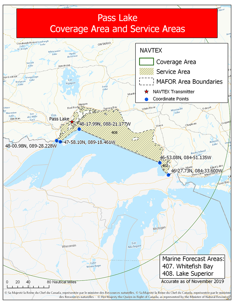
Figure 4-11 c) Pass Lake - Text version
This map shows the 300 nautical mile coverage area and service area for the NAVTEX transmitter located at Pass Lake, Ontario. The transmitter broadcasts maritime safety information into the service area within the coverage area. The service areas are linked to the Environment and Climate Change Canada marine forecast areas which are identified by their assigned numbers. The Pass Lake NAVTEX transmitter is responsible for areas 407 and 408.
| Coordinate | Feature |
|---|---|
| 48-00.98N, 089-28.228W | Western (lower) limit of marine forecast area 408 at the shoreline. |
| 47-58.10N, 089-18.461W | Western (lower) limit of marine forecast area 408 off shore. |
| 48-17.99N, 088-21.177W | Western (upper) limit where marine forecast area continues in an easterly direction. |
| 46-53-08N, 084-51.135W | Eastern limit of marine forecast area 408 where it meets western (lower) limit of 407. |
| 46-27.73N, 084-33.600W | Eastern limit of marine forecast area 407. |
Figure 4-11 d) Ferndale

Figure 4-11 d) Ferndale - Text version
This map shows the 300 nautical mile coverage area and service area for the NAVTEX transmitter located at Ferndale, Ontario. The transmitter broadcasts maritime safety information into the service area within the coverage area. The service areas are linked to the Environment and Climate Change Canada marine forecast areas which are identified by their assigned numbers. The Ferndale NAVTEX transmitter is responsible for areas 402, 403, 404, 405 and 406.
| Coordinate | Feature |
|---|---|
| 45-57.14N, 083-28.502W | Western (upper) limit of marine forecast area 405 along the shore. |
| 45-49.09N, 083-35.944W | Western (lower) limit of marine forecast area 405 off shore. |
| 45-20.47N, 082-30.865W | Western limit of marine forecast area 405 where it proceeds in a southeasterly direction. |
| 43-36.55N, 082-07.269W | Western limit of marine forecast area 405 where it proceeds in a southwesterly direction. |
| 43-01.32N, 082-24.394W | Western limit of marine forecast area 405 where it meets the shoreline. |
| 42-02.67N, 083-08.758W | Southwestern (upper) limit of marine forecast area 403 at the shoreline. |
| 41-51.35N, 083-03.428W | Southwestern (lower) limit of marine forecast area 403 off shore. |
| 41-40.65N, 082-41.271W | Southern limit of marine forecast area 403 where it proceeds in a easterly direction. |
| 41-40.41N, 082-23.847W | Southeast point of marine forecast area 403 where it proceeds in a northerly direction. |
| 42-11.22N, 081-18.728W | Southeast point of marine forecast area 403 where it proceeds in a northeast direction. |
| 42-50.14N, 078-54.809W | Northeast limit of marine forecast area 403 at the shoreline. |
| 43-27.25N, 079-11.772W | East limit of marine forecast area 402 where it proceeds in a northeast direction. |
| 43-37.52N, 078-41.931W | East limit of marine forecast area 402 where it proceeds in an easterly direction. |
| 43-37.56N, 076-47.261W | East limit of marine forecast area 402 where it proceeds in a northerly direction. |
| 44-04.31N, 076-27.118W | East limit of marine forecast area 402 at the shoreline. |
Figure 4-11 e) Moisie
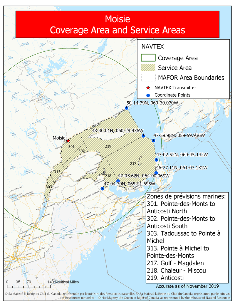
Figure 4-11 e) Moisie - Text version
This map shows the 300 nautical mile coverage area and service area for the NAVTEX transmitter located at Moisie, Quebec. The transmitter broadcasts maritime safety information into the service area within the coverage area. The service areas are linked to the Environment and Climate Change Canada marine forecast areas which are identified by their assigned numbers. The Moisie NAVTEX transmitter is responsible for areas 301, 302, 303, 313, 217, 218 and 219. The area between the service area and the coverage area will be covered by an adjacent transmitter.
| Coordinate | Feature |
|---|---|
| 47-04.70N, 065-21.695W | South limit of marine forecast area 218. |
| 47-03.62N, 064-00.069W | South limit of marine forecast area 218 where it intersects with 217. |
| 46-27.11N, 061-07.131W | Southeast limit of marine forecast area 217. |
| 47-02.52N, 060-35.132W | East limit of marine forecast area 217. |
| 47-59-98N, 059-59.936W | East limit of marine forecast area 217. |
| 48-30.01N, 060-29.936W | Northeast limit of marine forecast area 217 where it intersects with 219. |
| 50-14.79N, 060-30.070W | Northeast limit of marine forecast area 219. |
Figure 4-11 f) Chebogue
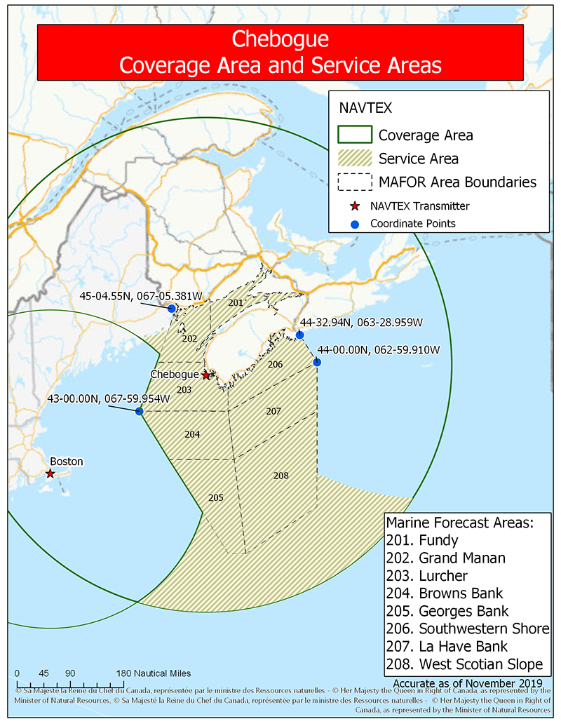
Figure 4-11 f) Chebogue - Text version
This map shows the 300 nautical mile coverage area and service area for the NAVTEX transmitter located at Chebogue, Nova Scotia. The map also shows the 200 nautical mile coverage area of the adjacent NAVTEX transmitter located at Boston, Massachusetts.
The Chebogue transmitter broadcasts maritime safety information into the service area within the coverage area. The service areas are linked to the Environment and Climate Change Canada marine forecast areas which are identified by their assigned numbers. The Chebogue NAVTEX transmitter is responsible for areas 201, 202, 203, 204, 205, 206, 207 and 208. This transmitter also provides broadcast services west of marine forecast area 202 where it intersects with the Boston coverage area and, south of marine forecast areas 205 and 208 out to the limit of the coverage area.
| Coordinate | Feature |
|---|---|
| 45-04.55N, 067-05.381W | west limit of marine forecast area 202. |
| 43-00.00N, 067-59.954W | west limit of marine forecast area 202 intersecting with 204. |
| 44-00.00N, 062-59.910W | Intersection of eastern limits of marine forecast areas 206 and 207. |
| 44-32.94N, 063-28.959W | Northeast limit of marine forecast area 206. |
Figure 4-11 g) Port Caledonia
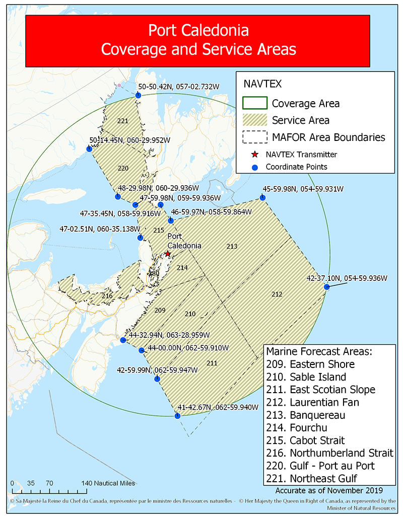
Figure 4-11 g) Port Caledonia - Text version
This map shows the 300 nautical mile coverage area and service area for the NAVTEX transmitter located at Port Caledonia, Nova Scotia. The Port Caledonia transmitter broadcasts maritime safety information into the service area within the coverage area. The service areas are linked to the Environment and Climate Change Canada marine forecast areas which are identified by their assigned numbers. The Port Caledonia NAVTEX transmitter is responsible for areas 209, 210, 211, 212, 213, 214, 215, 216, 220 and 221. Where a marine forecast area extends beyond the coverage area, the weather/ice bulletins will be broadcast in full. This transmitter will also provide broadcast services south of marine forecast areas 211 and 212 out to the limit of the coverage area.
| Coordinate | Feature |
|---|---|
| 44-32.94N, 063-28.959W | Western (upper) limit of marine forecast area 209. |
| 44-00.00N, 062-59.910W | Western (lower) limit of marine forecast area 209 and westerly (upper) limit of marine forecast area 210. |
| 45-59.99N, 062-59.947W | Western (lower) limit of marine forecast area 210 and westerly (upper) limit of marine forecast area 211. |
| 41-42.67N, 062-59.940W | Western (lower) limit of marine forecast area 210 where it intersects the cover area limit. |
| 42-37.10N, 054-59.936W | Eastern (lower) limit of marine forecast area 212 where it intersects the cover area limit. |
| 45-59.98N, 054-59.931W | Eastern limit of marine forecast area 213 . |
| 46-59.97N, 058-59.864W | Western limit of marine forecast area 213 where it intersects with the eastern limit of marine forecast area 215. |
| 47-35.45N, 058-59.916W | Northern limit of marine forecast area 215. |
| 47-02.51N, 060-35.138W | Western (lower) limit of marine forecast area 215. |
| 47-59.98N, 059-59.936W | Western (upper) limit of marine forecast area 215. |
| 48-29.98N, 060-29.936W | Western (lower) limit of marine forecast area 220. |
| 50-14.45N, 060-29.952W | Western (upper) limit of marine forecast area 220. |
| 50-50.42N, 057-02.732W | Eastern (upper) limit of marine forecast area 221 where it intersects the coverage area. |
Figure 4-11 h) Robin Hood Bay
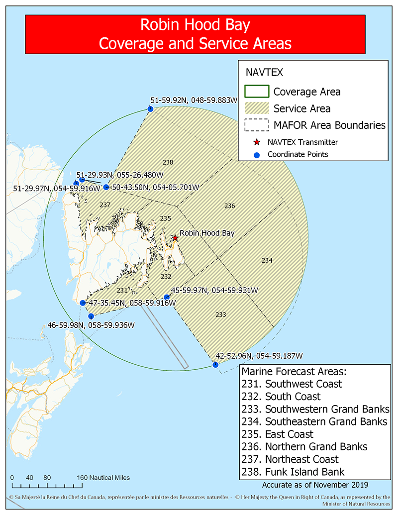
Figure 4-11 h) Robin Hood Bay - Text version
This map shows the 300 nautical mile coverage area and service area for the NAVTEX transmitter located at Robin Hood Bay, Newfoundland and Labrador. The transmitter broadcasts maritime safety information into the service area within the coverage area. The service areas are linked to the Environment and Climate Change Canada marine forecast areas which are identified by their assigned numbers. The Robin Hood Bay NAVTEX transmitter is responsible for areas 231, 232, 233, 234, 235, 236, 237 and 238. Where a marine forecast area extends beyond the coverage area, the weather/ice bulletins will be broadcast in full. This transmitter will also provide broadcast services east of marine forecast areas 234, 236 and 238 out to the limit of the coverage area.
| Coordinate | Feature |
|---|---|
| 47-35.45N, 058-59.916W | Western (upper) limit of marine forecast area 231. |
| 46-59.98N, 058-59.936W | Western (lower) limit of marine forecast area 231. |
| 45-59.97N, 054-59.931W | Western (upper) limit of marine forecast area 233. |
| 42-52.96N, 054-59.187W | Western (lower) limit of marine forecast area 233 where it intersects with the coverage area. |
| 51-59.92N, 048-59.883W | North limit of marine forecast area 238 where it intersects with the coverage area. |
| 50-43.50N, 054-05.701W | South limit of marine forecast area 238 where it intersects with marine forecast area 237. |
| 51-28.97N, 054-59.916W | Northwest limit of marine forecast area 237. |
| 51-29.93N, 055026.480W | Southwest limit of marine forecast area 237. |
Figure 4-11 i) Cartwright

Figure 4-11 i) Cartwright - Text version
This map shows the 300 nautical mile coverage area and service area for the NAVTEX transmitter located at Cartwright, Newfoundland and Labrador. The transmitter broadcasts maritime safety information into the service area within the coverage area. The service areas are linked to the Environment and Climate Change Canada marine forecast areas which are identified by their assigned numbers. The Cartwright NAVTEX transmitter is responsible for areas 222, 223, 224, 226, 227, 228 and 229. Where a marine forecast area extends beyond the coverage area, the weather/ice bulletins will be broadcast in full. This transmitter will also provide broadcast services northeast of marine forecast areas 223 and 227 out to the limit of the coverage area.
| Coordinate | Feature |
|---|---|
| 51-25.99N, 057-33.332W | Western (lower) limit of marine forecast area 222. |
| 50-50.42N, 057-02.732W | Eastern (lower) limit of marine forecast area 222. |
| 50-43.53N, 054-05.728W | Southwest (lower) limit of marine forecast area 223. |
| 51-55.86N, 049-18.575W | Northeast (lower) limit of marine forecast area 223 where it intersects with the coverage area. |
| 56-01.73N, 049-20.788W | Northeast point (upper) where the coverage area intersects with Greenland coverage area. |
| 56-00.00N, 050-00.000W | Northeast point (lower) of Greenland coverage area before the boundary changes to a westerly direction. |
| 58-20.69N, 054-20.331W | Point where coverage area intersects with Greenland coverage area along the southeast limit of marine forecast area 229. |
| 60-00.00N, 058-00.000W | Southwest point where Greenland coverage area extends into marine forecast area 229 before the boundary changes to a northwesterly direction. |
| 61-36.61N, 0-58-00.000W | Northwest point where Greenland coverage area intersects along the east (upper) limit of marine forecast area 229. |
| 62-00.00N, 063-59.808W | Northwest (upper) limit of marine forecast area 229. |
| 60-49.50N, 062-51.290W | Point where western limit of marine forecast area 229 intersects with the northeast limit of marine forecast area 228. |
| 60-24.18N, 064-27.801W | Southeast limit of marine forecast area 228 where it meets the shoreline. |
Figure 4-11 j) Iqaluit

Figure 4-11 j) Iqaluit - Text version
This map shows the 300 nautical mile coverage area and service area for the NAVTEX transmitter located at Iqaluit, Nunavut. The transmitter broadcasts maritime safety information into the service area within the coverage area. The service areas are linked to the Environment and Climate Change Canada marine forecast areas which are identified by their assigned numbers. The Iqaluit NAVTEX transmitter is responsible for areas 143, 144, 145, 147, 148, 149 and 150. Where a marine forecast area extends beyond the coverage area, the weather/ice bulletins will be broadcast in full. This transmitter will also provide broadcast services out to the southerly limit of NAVAREA XVIII and beyond marine forecast areas out to the coverage area limit or where the coverage area meets the Greenland coverage area.
| Coordinate | Feature |
|---|---|
| 62-19.07N, 057-59.891W | Eastern (lower) point where coverage area intersects with the Greenland coverage area. |
| 65-54.85N, 058-00.000W | Eastern (upper) point where coverage area intersects with the Greenland coverage area. |
| 67-00.00N, 059-29.836W | Northeast point where the coverage area intersects with the southeast limit of NAVAREA XVIII. |
| 67-00.00N, 077-35.564W | Northwest point where the coverage area intersects with southwest limit of NAVAREA XVIII. |
Figure 4-12 Regional NAVTEX Overview - Coverage and Service Areas
Figure 4-12 a) Western Region
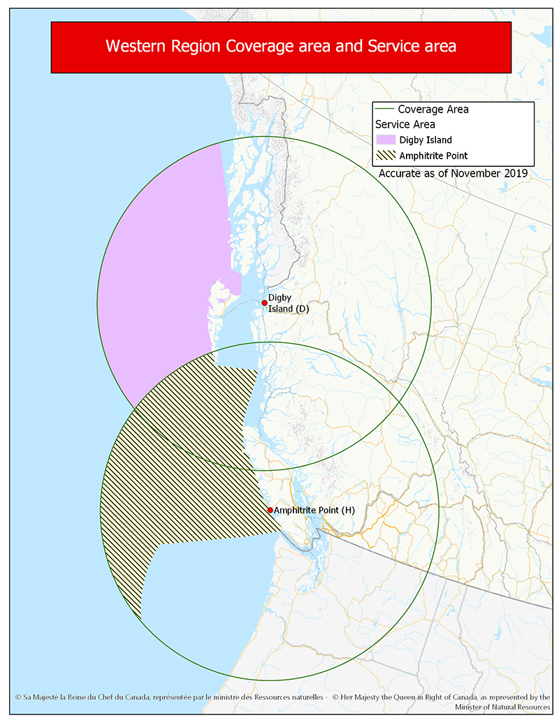
Figure 4-12 a) Western Region - Text version
This map shows a regional overview of the 300 nautical mile coverage areas and service areas for the 2 NAVTEX transmitters located at Digby Island and Amphitrite Point. These 2 transmitters broadcast maritime safety information into the service areas within their respective advertised coverage areas.
Figure 4-12 b) Great Lakes Region
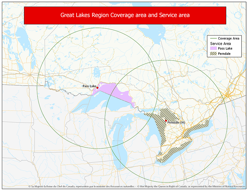
Figure 4-12 b) Great Lakes Region - Text version
This map shows a regional overview of the 300 nautical mile coverage areas and service areas for the 2 NAVTEX transmitters located at Ferndale and Pass Lake. These 2 transmitters broadcast maritime safety information into the service areas within their respective advertised coverage areas.
While the indicated coverage footprint of NAVTEX transmitters located at Pass Lake and Ferndale intersect over Lake Michigan, information specifically pertaining to Lake Michigan waters is not included on NAVTEX broadcasts
Figure 4-12 c) Gulf of St. Lawrence and Atlantic Region
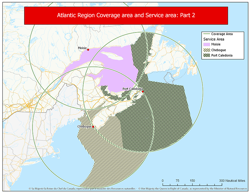
Figure 4-12 c) Gulf of St. Lawrence and Atlantic Region - Text version
This map shows a regional overview of the 300 nautical mile coverage areas and service areas for the 3 NAVTEX transmitters located at Moisie, Port Caledonia and Chebogue. These 3 transmitters broadcast maritime safety information into the service areas within their respective advertised coverage areas.
Figure 4-12 d) Atlantic Region: Newfoundland and Labrador
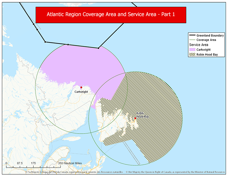
Figure 4-12 d) Atlantic Region: Newfoundland and Labrador - Text version
This map shows a regional overview of the 300 nautical mile coverage areas and service areas for the 2 NAVTEX transmitters located at Cartwright and Robin Hood Bay. These 2 transmitters broadcast maritime safety information into the service areas within their respective advertised coverage areas. It also shows the where the Cartwright coverage area limit is intersected by the coverage area provided by Greenland.
Figure 4-12 e) Arctic Region

Figure 4-12 e) Arctic Region - Text version
This map shows a regional overview of the 300 nautical mile coverage areas and service areas for the 2 NAVTEX transmitters located at Iqaluit and Cartwright. It also shows the where the coverage area limits are intersected by the coverage area provided by Greenland.
These 2 transmitters broadcast maritime safety information into the service areas within their respective advertised coverage areas.
4.3.3 World-Wide Navigational Warning Service (WWNWS)
4.3.3.1 NAVAREAS XVII and XVIII: Navigational Warnings
The Canadian Coast Guard has assumed responsibility of NAVAREA coordination for NAVAREAs XVII and XVIII as part of the World-Wide Navigational Warning Service (WWNWS).
Under the WWNWS, navigational warnings containing urgent information relevant to safe navigation that are broadcast in accordance with the Chapter IV of the International Convention for the Safety of Life at Sea (SOLAS).
NAVAREA warnings, which contain information specific to ocean going mariners, remain in force until cancelled or promulgated by other means.
NAVAREA XVII and XVIII warnings that are less than 42 days old are promulgated via SafetyNET II and SafetyCast.
The complete text of all In-Force NAVAREA warnings is available from the Canadian Coast Guard website
Alternatively, these may be requested by forwarding an email to the NAVAREA Operations desk at: navarea17.18@innav.gc.ca.
Figure 4-13 - Canadian NAVAREA Zones and Broadcast Areas

Figure 4-13 Canadian Navarea Zones and Broadcast Areas - Text version
The map portrayed in figure 4-13 is of Northern Canada. Shown are the zones for NAVAREA XVII in red and NAVAREA XVIII in green. These position limits are detailed in Table 4-14.
| NAVAREA XVII | NAVAREA XVII |
|---|---|
| 67°00N 168°58W | 67°00N 120°00W |
| 90°00N 168°58W | 90°00N 120°00W |
| 90°00N 120°00 | 90°00N 035°00W |
| 67°00N 120°00W | 67°00N 035°00W |
During the Arctic navigational season, NAVAREA XVII and XVIII warnings applicable to the Canadian Search and Rescue boundaries for waters North of 70 degrees latitude are broadcast (with limits to coverage area and reliability) using High Frequency Narrow Band Direct Printing (HF NBDP) on 8416.5 kHz at 03:30 UTC and 15:30 UTC. Refer to Iqaluit MCTS in Part 2, for details about the broadcast content.
| Hour UTC | Service | Frequency, Satellite, or System |
|---|---|---|
| 0330 | HF NBDP | 8416.5 kHzFootnote * |
| 1100 | NAV XVIII | AOR-E, AOR-W SafetyCast |
| 1130 | NAV XVII | AOR-W, POR, SafetyCast |
| 1530 | HF NBDP | 8416.5 kHzFootnote * |
| 2300 | NAV XVIII | AOR-E, AOR-W, SafetyCast |
| 2330 | NAV XVII | AOR-W, POR, SafetyCast |
Comments concerning the reception of NAVAREA XVII and XVIII broadcasts, especially above 75°N, would be appreciated and should be sent to:
NAVAREA XVII and XVIII
Prescott MCTS Centre
Telephone: 613-925-0666
Facsimile: 613-925-4519
E-mail: navarea17.18@innav.gc.ca
4.3.3.1.1 Inmarsat C- SafetyNET II
NAVAREAs XVII and XVIII warnings are broadcast in the English language directly into the appropriate GMDSS NAVAREA zone, with a broadcast overlap of 300 NM.
To learn more about the Inmarsat SafetyNET service, please consult their website or the SafetyNET manual (MSC.1/Circ.1364/Rev.2).
4.3.3.1.2 Iridium - SafetyCast
NAVAREAs XVII and XVIII warnings are broadcast in the English language directly into the appropriate GMDSS NAVAREA zone, with a broadcast overlap of 300 NM.
To learn more about the Iridium SafetyCast service, please consult their website or the SafetyCast Manual (MSC.1/Circ.1613).
4.3.3.2 NAVAREAS IV and XII
The National Geospatial-Intelligence Agency (NGA) of the United States of America is responsible for NAVAREAs IV and XII coordination.
NAVAREA IV covers the North Atlantic Ocean West of 35°W and north of 7°N. NAVAREA IV warnings are broadcasts over the Iridium SafetyCast and Inmarsat AMER satellites at 10:00 UTC and 22:00 UTC. Ice reports for the North Atlantic are broadcast at 22:00 UTC. NAVAREA IV warnings are broadcast over HF NBDP from: Boston (NMF) at 01:40 UTC on 6314 kHz, 8416.5 kHz, and 12579 kHz and at 16:30 UTC on 8416.5 kHz, 12579 kHz, and 16806.5 kHz.
NAVAREA XII covers the North Pacific Ocean east of 180° and north of the equator, plus the area north of 3°25’S and east of 120°W. NAVAREA XII warnings are broadcasts over the Iridium SafetyCast and Inmarsat APAC satellites at 10:30 UTC and 22:30 UTC. These messages are broadcast over HF NBDP by Honolulu (NMO) at 03:30 and 17:30 UTC daily, on 8416.5 kHz, 12579 kHz, and 22376 kHz.
Consult the publication NP283 (2) Admiralty List of Radio Signals, Volume 3, Part 2, for the listing of all NAVAREA Coordinators and broadcast schedules.
Mariners may also consult the International Maritime Organization (IMO) circular, COMSAR.1/Circ.51, for an updated list of all NAVAREA Coordinators.
NAVAREA broadcast schedules can be found in Annex 8 of the IMO circular, GMDSS.1/Circ.23 (as amended) GMDSS Master Plan of Shore-Based Facilities for GMDSS or the appropriate section of the GMDSS module of IMO’s Global Integrated Shipping Information System (GISIS).
4.3.3.3 Subject Matter for NAVAREA Warnings Messages
The following subjects are considered suitable for broadcast as NAVAREA warnings. This list is not exhaustive and should be regarded only as a guideline. Furthermore, it presupposes that sufficiently precise information about the item has not previously been disseminated in a Notice to Mariners:
- casualties to lights, fog signals and buoys and other aids to navigation affecting main shipping lanes;
- the presence of dangerous wrecks in or near main shipping lanes and if relevant, their marking;
- establishment of major new aids to navigation or significant changes to existing ones when such establishment or change might be misleading to shipping;
- the presence of large unwieldy tows in congested waters;
- drifting hazards including derelict ships, ice, mines, containers and other large items;
- areas where search and rescue (SAR) and anti-pollution operations are being carried out (for avoidance of such areas);
- the presence of newly-discovered rocks, shoals, reefs and wrecks likely to constitute a danger to navigation, and, if relevant, their marking;
- unexpected alteration or suspension of established routes;
- cable or pipe-laying activities, the towing of large submerged objects for research or exploration purposes, the employment of manned or unmanned submersibles, or other underwater operations constituting potential danger in or near shipping lanes;
- the establishment of research or scientific instruments in or near shipping lanes;
- the establishment of offshore structures in or near shipping lanes;
- significant malfunction of radio-navigation services and shore-based maritime safety information and radio services;
- information concerning special operations which might affect the safety of shipping, sometimes over wide areas, e.g. naval exercises, missile firings, space missions, nuclear tests, ordnance dumping zones, etc. It is important that where the degree of hazard is known, this information is included in the relevant warning. Whenever possible, such warnings should be originated not less than five days in advance of the scheduled event and reference may be made to relevant national publications in the warning;
- acts of piracy and armed robbery against ships;
- tsunamis and other natural phenomena, such as abnormal changes to sea level;
- World Health Organization (WHO) health advisory information; and
- security-related requirements, in accordance with the requirements of the International Ship and Port Facility Security Code only.
Figure 4-14 - World-Wide Navigational Warning Service - NAVAREAS
Figure 4-14 World-Wide Navigation Warning Service NAVAREAS - Text version
This map illustrates the NAVAREAS which form the World-wide Navigational Warning Service. It is divided into 21 areas each shown on the map in a different colour and labeled with its applicable number and a geographic name. On the northern section of the map are NAVAREAS XIX (Norway), XX (Russian Federation), XXI (Russian Federation), XVII and XVIII (Canada). In the centre section starting from the left, IV (United States), V (Brazil), I (United Kingdom), Baltic Sea (Sub-Area), II (France), III (Spain), IX (Pakistan), VIII (India), XIII (Russian Federation), XI (Japan) XII (United States), XVI (Peru), IV (United States). On the southern portion of the map starting from the left, VI (Argentina), VII (South Africa), X (Australia), XIV (New Zealand), XV (Chile) and VI (Argentina). Geographic descriptions for the areas involving Canada (Navareas XVII, XVIII, IV and XII) can be found previously under the headline World-wide navigational warning service (WWNWS).
4.3.4 Cellular Phone (*16) Service - Marine Emergencies
MCTS Centres in certain parts of Canada are connected to the cellular telephone network system where cellular telephone users can, in an emergency situation only, dial *16 on their cellular telephone to access an MCTS Centre in order to obtain assistance.
Mariners are cautioned that a cellular telephone is not a good substitute for a marine radio because the maritime mobile radio safety system in the southern waters of Canada is based principally on VHF communications. Furthermore, VHF has the advantage that a call can be heard by the closest MCTS Centre(s) and by ships in the vicinity which could provide immediate assistance. On the other hand, the telephone cellular network is a party-to-party system and the benefit of the broadcast mode in an emergency situation cannot be obtained.
Mariners are reminded that the use of marine radio distress frequencies to obtain assistance in an emergency situation is the best option and that cellular telephone should be used only as an alternative should the VHF radiotelephone set not be available. Standard distress alerting equipment, such as marine radio and EPIRBs, should never be replaced by cellular phone alone.
Note: Details of this service may be obtained by contacting local cellular telephone companies; however, mariners are cautioned that not all cellular telephone companies provide this service.
4.3.5 Direction Finding (VHF/DF) Service
MCTS Centres in certain parts of Canada are provided with VHF/DF equipment, primarily to determine or confirm the bearing, from a DF facility, of a vessel requiring assistance in a distress or other emergency situation. In addition, an estimated line of position from a DF facility can be provided to vessels that are uncertain of their locations. Location of VHF/DF facilities will be found in the appropriate centre listings in Part 2 of this publication. The intent of this service is not to provide a navigation service. Positions must be regarded as estimates only. Mariners are cautioned that any information provided shall be used at their own discretion.
4.3.5.1 Direction Finding Bearings
Any MCTS Centre will, on request, transmit signals that will enable a ship to take a radio bearing with its own direction finder. It is pointed out to masters of ships fitted with direction finding equipment employing DF loops that serious error may result in bearings taken if metallic material or equipment (poles, wires, winches, etc.) are erected in proximity to the DF antenna equipment after calibration.
Masters of ships are urged to exercise caution in the use of commercial radio broadcasting stations as radio beacons. Bearings taken on such stations may be very inaccurate owing to errors caused by coastal refraction and the calibration of the Direction Finder employed may vary considerably due to the wide difference in frequencies used, (i.e. the standard broadcast band spreads over approximately 1060 kHz). In addition, it is advisable to make certain that the position of the broadcast transmitter (not the studio) is accurately known before using it as a navigation aid.
4.3.6 Sailing Plan Service
All small craft operators, including those making day trips, are encouraged to file a Sailing Plan with a responsible person. This person should be instructed to call the Joint Rescue Coordination Centre (JRCC) or Maritime Rescue Sub-Centre (MRSC) if the vessel becomes overdue. The telephone number can be found at the front of most telephone books and should be included with the Sailing Plan. In circumstances where it is not possible to file a Sailing Plan with a responsible person, a Sailing Plan may be filed by telephone, radio or in person, with any CCG MCTS Centre. While at sea, masters/operators who have filed a sailing plan with an MCTS Centre are encouraged to file a daily position report during long trips. Upon your return, be sure to close (or deactivate) the Sailing Plan you filed earlier. Forgetting to do so can result in an unwarranted search for you.
The information to be provided should be in accordance with the listing below:
- vessel identification (boat’s name and licence number);
- sail or power;
- vessel size and type;
- colour of hull, deck, and cabin;
- type of engines;
- other distinguishing features;
- radios and channels monitored (MF/HF/VHF);
- Maritime Mobile Service Identity (MMSI);
- satellite and/or cellular telephone number;
- description of life rafts or small boats available;
- number and type of flares;
- number of lifejackets PFDs and/or survival suits;
- other safety equipment;
- name, address, and telephone number of vessel owner;
- other information;
- date and time of departure;
- number of people on board;
- departure point;
- route and stop-over points;
- destination;
- estimated date and time of arrival at destination; and,
- telephone number of an emergency contact person.
4.3.7 Search and Rescue in Canadian Areas of Responsibility
The Canadian Forces (CF) in co-operation with the Canadian Coast Guard has overall responsibility for coordination of federal aeronautical and maritime Search and Rescue (SAR) activities in Canada, including Canadian waters and the high seas off the coasts of Canada. The CF provides dedicated SAR aircraft in support to marine SAR incidents. The CCG coordinates maritime SAR activities within this area and provides dedicated maritime SAR vessels in strategic locations. Joint Rescue Coordination Centres (JRCC) are maintained at Victoria, B.C., Trenton, Ont. and Halifax, N.S. These centres are staffed 24 hours a day by Canadian Forces and CCG personnel. Each JRCC is responsible for an internationally agreed upon designated area known as a Search and Rescue Region (SRR). In addition, two Maritime Rescue Sub-Centres (MRSC), staffed by CCG personnel are maintained at Québec, QC and St. John's, NL to coordinate local marine SAR operations.
Joint Rescue Coordination Centre (JRCC)/Maritime Rescue Sub-Centre (MRSC)
JRCC Halifax, NS
Telephone: 1-800-565-1582 Maritimes Region
1-800-563-2444 Newfoundland and Labrador Region
902-427-8200 Satellite, Local or Out of Area
Facsimile: 902-427-2114
Email: jrcchalifax@sarnet.dnd.ca
MRSC St. John's, Newfoundland and Labrador
Telephone: 1-800-563-2444 Newfoundland and Labrador Region
709-772-5151 Satellite, Local or Out of Area
Facsimile: 709-772-2224
Email: mrscsj@sarnet.dnd.ca
MRSC Québec, QC
Telephone: 1-800-463-4393 Québec Region
418-648-3599 Satellite, Local or Out of Area
Facsimile: 418-648-3614
Email: mrscqbc@dfo-mpo.gc.ca
JRCC Trenton, ON
Telephone: 1-800-267-7270 In Canada
613-965-3870 Satellite, Local or Out of Area
Facsimile: 613-965-7279
Email: jrcctrenton@sarnet.dnd.ca
JRCC Victoria, British Columbia
Telephone: 1-800-567-5111 British Columbia and Yukon
250-413-8933 Satellite, Local or Out of Area
# 727 Cellular (#SAR)
Email: jrccvictoria@sarnet.dnd.ca
4.3.7.1 Canadian Coast Guard Auxiliary or Royal Canadian Marine Search and Rescue in British Columbia
The Canadian Coast Guard Auxiliary (CCGA) or Royal Canadian Marine Search and Rescue (RCM-SAR) is an association of approximately 4500 dedicated volunteers operating close to 1300 vessels to support the CCG in Marine Search and Rescue.
For more information on maritime SAR services in Canada, refer to Section 28 of the Annual Edition of Notices to Mariners, published by the CCG, Marine Navigation Services.
4.3.8 Marine Communications and Traffic Services Message Service
4.3.8.1 Messages Handled Without Charge by MCTS Centres
- messages pertaining to weather or ice information and ice routing;
- messages concerning aids to navigation;
- Amver Messages, addressed AMVER HALIFAX;
- radiomedical messages;
- messages reporting pollution;
- messages addressed to a port or a member of the CCG that involve a report of a ship movement, position or condition;
- messages addressed to a Joint Rescue Coordination Centre (JRCC) or Maritime Rescue Sub-Centre (MRSC);
- pilotage messages;
- official Naval messages;
- quarantine messages addressed to “Quarantine”; and
- messages requesting a doctor to meet a ship on arrival.
4.3.8.2 Weather Messages
Weather reports in the international meteorological code, made at the standard synoptic hours of 00:00, 06:00, 12:00 and 18:00 UTC, are solicited from ships of all nationalities which have been recruited by their own national weather service, or other weather services, to make weather reports on a regular basis. These reports should be made and transmitted to the nearest MCTS Centre, irrespective of the ship’s position. In fact, reports made close to, or even within sight of land, are equally important to reports made offshore, due to the greater variability of weather conditions in proximity to a coastline.
4.3.8.3 Pollution Messages
All vessels plying Canadian and adjacent waters are requested to report oil slicks or pollution of any type to the nearest MCTS Centre.
4.3.8.4 Medical Advice Messages
Masters of ships may obtain medical advice by addressing a radiotelegram to “Radiomedical” and routing it via the nearest MCTS Centre which will refer the message to the nearest medical authority and transmit the reply to the ship.
4.3.8.5 Quarantine Messages
-
In the following circumstances, and per the Quarantine Act, the person in charge of a vessel shall inform a quarantine officer prior to entering or exiting Canada where, in the course of the voyage:
- 1. A person on board meets the syndromal case definition:
- has a fever of 38°C or greater or 2 or more signs of fever, such as:
- shivering
- flushed skin
- excessive sweating
- complaints of feeling feverish
- and has 1 or more of the following symptoms:
- difficulty breathing
- repeated cough
- diarrhea
- headache
- recent confusion
- skin rash
- bruising or bleeding without previous injury
- has a fever of 38°C or greater or 2 or more signs of fever, such as:
- There is a death on board.
- Human remains are on board.
2. Appears obviously unwell or coughs with blood
- 1. A person on board meets the syndromal case definition:
- To inform a quarantine officer, the person in charge of a vessel shall submit a Maritime Declaration of Health (MDH) 24-48 hours before the first port of arrival in Canada and as soon as possible before departing the last port in Canada. If it is not possible to submit a MDH, the person in charge of a vessel can inform a quarantine officer by emailing the Public Health Agency of Canada (PHAC) Central Notification System (CNS) at cns-snc@phac-aspc.gc.ca or by calling the PHAC CNS at 1-833-615-2384. Should there be any change in the situation being reported, an updated report must be sent. Please visit Guidance for marine operators: Reporting Illness on board for information.
- All notifications (new or updated) submitted 24 hours or less prior to arrival must be accompanied by a call to CNS at 1-833-615-2384.
- The person in charge of a vessel who wishes to change their port of destination after receiving instructions from a quarantine officer shall notify the quarantine officer of such a change and request new instructions.
4.3.8.6 Pilotage Messages
For detailed information on Notices to Obtain Pilot, Notices of Departure, Notices of Movage, Optional Notices and Required Information, please refer to Section 23 of the latest Annual Edition of Notices to Mariners, published by the CCG, Marine Navigation Services.
4.3.8.7 Official Naval Messages
For detailed information on Naval Messages to Canadian and Commonwealth ships in Canadian areas, please refer to Section 39 of the latest Annual Edition of Notices to Mariners, published by the CCG, Marine Navigation Services.
4.3.9 Icebreaking and Ice Routing Services
4.3.9.1 Ice Navigation in Canadian Waters
The nautical publication Ice Navigation in Canadian Waters is published by the CCG in collaboration with Transport Canada, Canadian Ice Service, and the Canadian Hydrographic Service. The Navigation Safety Regulations, 2020 require this publication to be carried on board if the vessel is making a voyage during which ice may be encountered. The publication is available to download, free of charge, from the Ice Navigation in Canadian Waters site.
There are a variety of icebreaking and support services available to ships transiting Canadian ice-covered waters. Ice Operations Centres are in operation seasonally for the Canadian Arctic or the southern Canadian waterways. These centres work in conjunction with MCTS Centres to provide up-to-date ice information, to suggest routes for ships to follow through or around ice, and to coordinate icebreaker assistance to shipping.
Ice Operations Centres are in contact with icebreakers at all times and monitor progress of shipping within their area of responsibility. In addition, Environment and Climate Change Canada’s Canadian Ice Service (CIS) has fully qualified Ice Service Specialists supporting the icebreaking operations on a full-time basis throughout the ice navigation season at the office as well as on icebreakers equipped with a helicopter to conduct ice reconnaissance flights on a daily basis. The Coast Guard Icebreaking Superintendents have a complete picture of the prevailing ice conditions in their area and are therefore well equipped to provide recommendations on the best routes to pursue.
To obtain the maximum benefit from the service, it is essential that reports from ships ensure a continuous watch on the ship’s progress by the CCG’s Ice Operations Centres so that, in the event icebreaker support becomes necessary, this can be provided with a minimum of delay. There are a limited number of icebreakers available to support shipping. Masters are encouraged to follow the recommended route with which they are provided. They may also assist and support this service by providing reports to the ice specialist about the ice they encountered during transit.
4.3.9.2 Joint Industry-Government Guidelines
Special risks of ice damage may exist in certain waters off the East Coast of Canada during winter and spring months. These risks may affect safety and contribute to marine pollution, thus the Joint Industry-Government Guidelines for the Control of Oil Tankers and Bulk Chemical Carriers in Ice Control Zones of Eastern Canada (JIG) – TP15163 were developed and have been in effect since November 1979.
These Guidelines apply to all laden oil tankers and to tankers carrying liquid chemicals in bulk when proceeding through an active Ice Control Zone in Eastern Canadian waters and fishing zones south of 60° North. The CCG may declare any ice control zone to be an active Ice Control Zone and promulgate this information via Navigational Warning (NAVWARN) and Notices to Mariners. When proceeding through an active Ice Control Zone, all ships to which the Guidelines apply should have on board a copy of the guidelines and at least one "Ice Advisor", who meets the requirements as prescribed in JIGs.
The following may be contacted for information on ice control zones:
Ice Atlantic (Operating from December to May)
Canadian Coast Guard Ice Operations Centre
P.O. Box 5667
St. John’s NL A1C 5X1
Telephone: 709-772-2078
1-800-565-1633 (option 7)
Ice conditions
Ice conditions
Ice Central (Arctic, Great Lakes, and St. Lawrence sectors)
Canadian Coast Guard Ice Operations Centre
105 McGill Street, 5th floor
Montréal, QC H2Y 2E7
Arctic Sector (Operating from mid-June to late November)
Telephone: 514-283-2784
Email: DFO.CCGIceOpsArctic-OpsGlaceArcticGCC.MPO@dfo-mpo.gc.ca
Arctic Ice conditions
Telephone: 514-283-1752
514-283-2069
Great Lakes Sector (Operating from mid-December to mid-April)
Telephone: 514-283-2784
Email: DFO.CCGCentralIceOpsGreatLakes-GrandsLacsOpsglacesCentreGCC.MPO@dfo-mpo.gc.ca
Great Lakes Ice conditions
Telephone: 514-283-1752
514-283-2069
St. Lawrence Sector (Operating from mid-December to late April)
Telephone: 514-283-1746
Email: DFO.CCGCentralIceOpsStLawrence-StLaurentOpsGlacesCentreGCC.MPO @dfo-mpo.gc.ca
St. Lawrence Ice conditions
Telephone: 514-283-1752
514-283-2069
Email: ssgstlaurent-issstlawrence@ec.gc.ca
Consult the complete version of JIG TP 15163 B (2011).
4.3.10 Canadian Hydrographic Service (CHS)
4.3.10.1 Adoption of the World Geodetic System 1984 (WGS84) for CHS Charts
CHS has adopted WGS84 which is compatible with Global Navigation Satellite Systems (GNSS). Existing nautical charts may also reference the North American Datum 1983 (NAD83), which is considered equivalent to WGS84. In a limited number of cases, an older horizontal datum may be used and will require GNSS positions to be adjusted using the chart-specific Horizontal Datum note, as shown on the chart. The mariner should always check the Horizontal Datum note shown on CHS charts for additional instructions.
Note: See “Section 4.1.5.1 Positions” in the Radio Aids to Marine Navigation publication for additional comments regarding the use of geographic positions.
4.3.11 Inspection of Radio Apparatus
The Canadian Coast Guard, on behalf of Transport Canada, is responsible for the conduct of ship radio inspections pursuant to the Canada Shipping Act, 2001. Queries concerning the standards governing inspections of radio apparatus fitted in ships for safety purposes may be sent to:
Program Manager, Ship Radio Inspection
Fisheries and Oceans Canada
Canadian Coast Guard
222 Nepean Street
Ottawa ON K2P 0B8
Inquiries: Info.XNCR@dfo-mpo.gc.ca
Owners and masters of Canadian ships, that are required to be fitted with a radio installation under the provisions of the Canada Shipping Act, 2001 are reminded that:
The master of a ship shall ensure that the ship station is inspected by a radio inspector in accordance with section 240 of the Navigation Safety Regulations, 2020.
A non-Canadian ship which does not have a valid Radio Safety Certificate on board may be detained by a port Customs Officer until a valid certificate has been obtained.
A fee for the conduct of ship radio inspections is levied in accordance with the Ship Radio Inspection Fees Regulations. The fee is payable upon completion of the inspection.
Owners and masters of Canadian vessels are advised that Transport Canada has delegated the authority to issue radio inspection certificates to Recognized Organizations under the Delegation Statutory Inspection Program. Vessels enrolled in the Delegation Statutory Inspection Program, as well as classed ships, are encouraged to contact a Recognized Organization for their radio inspection required by regulations under the Canada Shipping Act, 2001. Currently, the Recognized Organizations are: the American Bureau of Shipping; Bureau Veritas; ClassNK; Det Norske Veritas Germanischer Lloyd; Korean Register; Lloyd’s Register; and RINA Services SpA.
Validity Period of a Radio Inspection Certificates issued under the Navigation Safety Regulations, 2020
The following vessels are eligible for radio inspection certificates with a maximum duration of 4 years:
- Vessels operating exclusively in Sheltered Waters;
- Vessels operating exclusively within the Inland Waters of Canada; or
- Vessels operating exclusively within Sea Area A1 as defined by the Navigation Safety Regulations, 2020
Vessels operating outside the above areas are eligible for radio inspection certificates with a maximum duration of 1 year.
Applications for radio inspections of Non-Delegated Canadian ships should be filed with the Canadian Coast Guard. The form entitled: Application for Radio Inspection, Compulsory Fitted Ships (FP-5286-E) (PDF, 47 KB) should be used for this purpose. Such request by owners, agents or masters should be received by the Canadian Coast Guard at least three working days in advance of the date requested for inspection.
The owners, agents or masters of Canadian ships requiring radio inspection while outside of Canada should make application by fax or letter to:
Transport Canada
Director General
Marine Safety Directorate
Tower C, Place de Ville
330 Sparks Street
Ottawa ON K1A 0N
Telephone: 613-998-0610
Facsimile: 613-954-1032
Non-Canadian ships (except Liberian ships) may obtain a cargo Ship Safety Radio Certificate (GMDSS) in Canada. Applications should originate with the owners, ship agents or masters of the ships concerned and be supported by confirmation from the Consul or other official representative of the country in which the ship is registered. Confirmation shall be in writing. It is the responsibility of the owner, agent or master to contact the Consul or official representative and arrange to submit the necessary confirmation to the local Canadian Coast Guard inspection office. Where time is limited, a verbal request for an inspection may be accepted from the Consul or official representative (a person who has a document from an Administration giving them the official power to act on their behalf), provided that the confirmation is submitted later.
Applications for radio inspections of Canadian ships wintering in US Great Lakes ports should be made by the owners, agents or masters on FCC form 809 and filed directly with the FCC Field Engineering office nearest to the port of which the inspections are desired. Copies of form 809 are available from any of the FCC offices serving the Great Lakes.
4.3.11.1 Ship Radio Inspection Contacts
CCG Newfoundland and Labrador
Fisheries and Oceans Canada
Telephone and Fax: 1-888-454-3177
Outside Canada
Telephone Facsimile: 709-772-3467
Email: xnfltsc@dfo-mpo.gc.ca
https://e-nav.ccg-gcc.gc.ca/sri
Charlottetown, Prince Edward Island
Senior Technologist
Fisheries and Oceans Canada
Canadian Coast Guard
Unit 2 – 184 John YEO Drive
Charlottetown, PE C1C 3J3
Telephone: 902-407-7521
Facsimile: 902-407-7435
Email: xmartsc@dfo-mpo.gc.ca
https://e-nav.ccg-gcc.gc.ca/sri
Saint John, New Brunswick
Senior Technologist
Fisheries and Oceans Canada
Canadian Coast Guard
175 McIlveen Drive
Saint John, NB E2J 4Y6
Telephone: 506-636-4743
Facsimile: 506-636-5000
Email: xmartsc@dfo-mpo.gc.ca
https://e-nav.ccg-gcc.gc.ca/sri
Dartmouth, Nova Scotia
Senior Technologist
Fisheries and Oceans Canada
Canadian Coast Guard
P.O. Box 1006
Dartmouth, NS B2Y 4A2
Telephone: 902-407-7521
Facsimile: 902-407-7435
Email: xmartsc@dfo-mpo.gc.ca
https://e-nav.ccg-gcc.gc.ca/sri
Sydney, Nova Scotia
Senior Technologist
Fisheries and Oceans Canada
Canadian Coast Guard Ships
1190 Westmount Road
Sydney, NS B1R 2J6
Telephone: 902-407-7521
Facsimile: 902-407-7435
Email: xmartsc@dfo-mpo.gc.ca
https://e-nav.ccg-gcc.gc.ca/sri
Yarmouth, Nova Scotia
Senior Technologist
Fisheries and Oceans Canada
Canadian Coast Guard
215 Main Street
Yarmouth, NS B5A 1C6
Telephone: 902-407-7521
Facsimile: 902-407-7435
Email: xmartsc@dfo-mpo.gc.ca
https://e-nav.ccg-gcc.gc.ca/sri
Hay River, Northwest Territories
Supervisor of Technical Maintenance
Fisheries and Oceans Canada
Canadian Coast Guard Ships Electronics Workshop
42037 MacKenzie Highway
Hay River, NT X0E 0R9
Telephone: 867-874-5530
Facsimile: 867-874-5532
Richmond, British Columbia
Supervisor of Technical Maintenance
Fisheries and Oceans Canada
Canadian Coast Guard Ships Electronic Workshop
4270 Inglis Drive
Richmond, BC V7B 1L7
Telephone: 604-666-2311
Facsimile: 604-666-1786
Victoria, British Columbia
Supervisor of Technical Maintenance
Fisheries and Oceans Canada
Canadian Coast Guard Ships Electronic Workshop
25 Huron Street
Victoria, BC V8V 4V9
Telephone: 250-480-2644
Facsimile: 250-480-2666
Lazo, British Columbia
Supervisor of Technical Maintenance
Fisheries and Oceans Canada
Canadian Coast Guard Ships Electronic Workshop
299 Wireless Road
P.O. Box 220
Lazo, BC V0R 2K0
Telephone: 250-339-5211
Facsimile: 250-339-7922
Prince Rupert, British Columbia
Supervisor of Technical Maintenance
Fisheries and Oceans Canada
Canadian Coast Guard Ships Electronic Workshop
P.O. Box 906
Prince Rupert, BC V8J 4B7
Telephone: 250-627-3073
Facsimile: 250-624-6518
4.3.12 Radio Station Licensing and MMSI Numbers
To obtain further information on radio station licensing and Maritime Mobile Service Identity (MMSI) numbers contact Innovation, Science and Economic Development Canada at: Innovation, Science and Economic Development Canada or locate the nearest Innovation, Science and Economic Development Canada office through the local telephone directory.
4.3.13 Marine Telephone Service
4.3.13.1 General
This service enables a person aboard a ship to speak directly to any person ashore, or vice versa. The service is an extension of the public telephone system to ships at sea through MCTS Centres. Long distance ship-to-shore calls may only be made as collect calls or charged to a telephone company calling card/pre-paid card. Refer to Part 2 to find MCTS Centres that provide the marine telephone call service.
4.3.13.2 Placing a Marine Telephone Call
Ship to Shore
- Listen to make sure that the MCTS Centre is not busy with another ship.
- Call the MCTS Centre and when communication has been established give the following:
- name of the city being called;
- name and/or telephone number of the person being called;
- name of the caller or the number of the caller’s telephone company credit calling card (if applicable).
- When the call is completed, sign off, using the name and call sign of the ship.
Shore to Ship
- Dial the appropriate MCTS Centre.
- Give the MCTS Officer the name of the person and ship being called.
Receiving a Marine Telephone Call
- When you hear your ship being called, reply, giving your ship’s name and call sign.
- At the end of the conversation, sign off by announcing the name and call sign of your vessel.
4.3.13.3 Radiomedical Calls
Mariners may obtain medical advice by calling an MCTS Centre and requesting to be connected to a medical professional. The CCG will connect the vessel to an appropriate medical professional via the Marine Telephone System.
For mariners who wish to make their own arrangements for medical advice, radiomedical services are available in numerous languages to vessels flying any flag at any location through the International Radio-medical Centre (CIRM) in Rome, Italy. This centre is staffed 24/7/365 by specially trained physicians and radio operators who also have access to specialists in all medical branches. The CIRM can be contacted via the following means:
Telephone: 39 06 59290263
Email: telesoccorso@cirm.it
Web: www.cirmtmas.it/
- Date modified: