
The Canadian Aids to Navigation System 2023
Table of Contents
- Preface
- Introduction
- The Canadian Aids to Navigation System
- Legal provisions relevant to, or governing aids to navigation
- Canadian Coast Guard Aids to Navigation
- Other government aids to navigation
- Private aids to navigation
- Canadian light flash characters
- Floating Aids to Navigation (Buoys)
- Fixed aids to navigation
- Daymarks and daybeacons
- Audible aids
- Sector lights
- Electronic aids to navigation
- Global Navigation Satellite System (GNSS)
- Related publications
- Canadian Coast Guard Aids to Navigation offices
- IALA / AISM Maritime Buoyage System
Preface
The Canadian Coast Guard is pleased to release the 2023 edition of the Canadian Aids to Navigation System publication. This edition replaces the 2011 edition as the new standard for aids to navigation in Canada.
As you will notice, there have been several improvements made to this edition. These changes include:
- The removal of all references to DGPS, as a result of the Canadian DGPS broadcast network termination as of December 15, 2022, (reference: Notice to Mariners 1206/22).
- The substitution, in the English version only, of the term “aural aid” by “audible aid” to align with IALA’s terminology. French terminology is not affected.
- An updated definition for interpretation of upstream direction.
- A new poster-style quick reference guide in 2 different printable versions:
- on 3 X 8.5x11 inch;
- on 3 X 11x14 inch (bigger font size).
- An updated Legal provisions relevant to, or governing Aids to Navigation section to reflect current acts and regulations associated with aids to navigation.
- The renaming of the Navigation Protection Act (NPA) as the Canadian Navigable Waters Act (CNWA).
- The renaming of the Charts and Nautical Publication Regulations, 1995, now consolidated into Navigation Safety Regulations, 2020.
- The renaming of the Notices to Shipping (NOTSHIP), now referred to as Navigational Warnings (NAVWARN).
- For safety and concordance between the English and French versions, the definition of diving buoy has been corrected and now reflects the original text.
- The addition of many links.
- The addition of references to AIS aids to navigation (AtoN).
- The addition of visual references (drawings).
Introduction
General
Definition
Aids to Navigation (AtoN) are devices or systems, external to a vessel, which are provided to assist mariners in determining position and course, to warn of dangers or obstructions or to advise of the location of the best or preferred route.
Intended audience and uses
This aids to navigation (AtoN) reference publication is intended for a broad audience engaged in the maritime domain. It provides guidance:
- to Canadian and international navigators using or planning on using Canadian AtoN to navigate safely in Canadian waters,
- on AtoN interpretation, purposes and characteristics,
- to quickly reference publications and legislation related to AtoN.
The map format can be printed and used as a quick reference guide (vertical) (PDF, 1.94 MB, available in PDF format only) and includes condensed information. Also, the video can be utilized as an audible and visual supplement.
Responsibility
The Canadian Coast Guard is mandated, though not obligated, to provide aids to navigation in Canadian waters with the exception of waterways such as the Trent-Severn and Rideau waterways, which are provided by Parks Canada. The Canadian Coast Guard undertakes to provide such aids to navigation deemed practical and necessary, as justified by existing policies, procedures, and directives.
Other publications
To facilitate the proper understanding and interpretation of their function, aids to navigation are to be used in conjunction with the Canadian Aids to Navigation System and other marine publications, in particular, nautical charts, List of Lights, Buoys and Fog Signals, Radio Aids to Marine Navigation, Navigational Warnings (NAVWARN), Notices to Mariners (NOTMAR), Canadian Sailing Directions, and An Owner’s Guide to Private Buoys (PDF, 987 KB, available in PDF format only).
The Canadian Aids to Navigation System
The Canadian Aids to Navigation System is comprised of a mix of visual, audible, and electronic aids to navigation.
Visual aids
Visual aids are short range aids to navigation including buoys, daybeacons, daymarks and lights. In Canada, a combined Lateral-Cardinal system of visual aids is used. Knowledge of the characteristics of each of these basic types of aids is a prerequisite to the safe use of the system.
Lateral aids
The lateral system of buoyage in use in Canadian waters is taken from International Association of Marine Aids to Navigation and Lighthouse Authorities (IALA) Region B (see IALA Maritime Buoyage System). Lateral aids may be in the form of either buoys or fixed aids. These aids indicate the location of hazards and the safest or deepest water by indicating the side on which they are to be passed.
The correct interpretation of lateral aids requires knowledge of the direction of buoyage known as the “upstream direction”. In general, the upstream direction is the direction taken by a vessel when proceeding from seaward toward the headwaters of a river or into a harbour.
When a vessel is proceeding in the upstream direction, starboard hand aids must be kept to starboard (right) and port hand aids must be kept to port (left).
Cardinal aids
Cardinal aids may be in the form of either buoys or fixed aids.
Cardinal aids indicate the location of hazards and the safest or deepest water by reference to the cardinal point of the compass. There are four cardinal marks: North, East, South and West, which are positioned so that the safest or deepest water is to be found to the named side of the mark (e.g. to the north of a north cardinal mark).
Audible aids
Audible aids are sound-producing devices, which serve to warn the mariner of a danger under low visibility conditions. Buoy-mounted bells and whistles require wave action in order to produce sound. Fog signals on shore are operated when visibility is reduced to less than 2 nautical miles. See “Audible Aids” in the Canadian Aids to Navigation System section.
Electronic aids
The electronic aids used in the Canadian system include AIS AtoN (Automatic Information System Aids to Navigation), radar reflectors and radar beacons.
The advent of e-Navigation and its many possibilities is being monitored for potential impacts and implemented to meet the changing needs of navigation. Actions to date include the introduction of technologies enabling new types of electronic aids to navigation.
Radar reflectors are passive devices which are used to enhance the radar image of aids to navigation whereas radar beacons (RACON) are active devices which, by returning an identifiable radar signal, provide precise identification of the location they are marking.
Notes:
- A detailed listing of AIS AtoN is contained in the interactive map at the Canadian e-Navigation portal.
- A detailed listing of all lighted visual aids and all fog signals is contained in the List of Lights, Buoys and Fog Signals publication.
- A detailed listing of Radio Beacons and Radar Beacons is contained in the Radio Aids to Marine Navigation publication.
Winter navigation
Winter ice conditions may necessitate the removal of buoys and the closing of the navigation season. The operation of aids to navigation and associated electronic systems on shore may also be discontinued during such times. Some lights may be replaced by lights of lower intensity.
In less severe ice conditions, unlighted summer buoys may be left in place or lighted buoys may be replaced by unlighted winter spar buoys. Mariners who use channels marked by such buoys outside the official opening of the navigation season are cautioned that these aids may not be in their advertised positions due to storms and shifting ice.
The opening and closing of navigation, the seasonal removal, substitution or position of buoys and the temporary discontinuance of other aids to navigation are always advertised. Mariners are encouraged to check local marine radio broadcasts, Navigational Warnings (NAVWARNS), and published Notices to Mariners (NOTMARs) for this information.
Night navigation
Buoys and fixed aids may be enhanced with a light and retroreflective material which is activated by a light source, such as a searchlight. This retroreflective material is coloured to signify the type of the aid and, for buoys at close range, displays the identification numbers, letters or symbols.
Speed and navigation
Aids to navigation systems cannot be foreseen to perform adequately in situations involving excessive speed. The Canadian Coast Guard advises mariners to conform to local speed restrictions where applicable and to exercise good judgement in all situations. Responsibility for avoiding collisions is shared by everyone using the waterway.
Mariners are especially urged to reduce speed and proceed with caution under poor weather conditions, reduced visibility, or near physical hazards (i.e. night navigation, in hazardous or high traffic areas and where ice has formed). Under these conditions, consideration must be given to the possibility of equipment failures, to limitations of the aids to navigation, and to reduced reaction times; problems which are only compounded by high speeds.
Rule 6 of Collision Regulations, under the Canada Shipping Act, 2001, sets out guidelines relating to safe speed.
Cautions in the use of aids to navigation
- Mariners are cautioned not to rely solely on buoys for navigation purposes. Navigation should be by bearings or angles from fixed aids on shore or other charted landmarks and by sounding or through the use of satellite or radio-navigation systems, whenever possible.
- Most aids to navigation are not under continuous observation and mariners should be aware that failures and displacements do occur. The Canadian Coast Guard does not guarantee that all aids to navigation will operate as advertised and in the positions advertised at all times. Mariners observing aids to navigation not operating, out of position, operating at reduced service, showing improper characteristics, damaged, or missing are responsible for reporting such problems to the nearest Canadian Coast Guard Marine Communications and Traffic Services Centre immediately or to the closest Canadian Coast Guard office.
- Aids to navigation are subject to damage, failure, and moving off position, which may be caused by ice, storms, vessel strikes, and power failures. Ice and storm damage may be widespread and require considerable time to repair. Damage to an isolated aid may exist for a long time without being discovered and reported. Floating aids and pier lights in or near the water which are exposed to particularly rigorous strain during ice movement are at the greatest risk of damage.
- Mariners are cautioned that aids to navigation may fail to exhibit their advertised characteristics. Lights may be extinguished or appear at a reduced intensity and audible signals may not function due to ice, collisions, mechanical failure, and, in the case of bell and whistle buoys, calm water. The shape of an aid to navigation may be altered by ice formation or damage. The colour of an aid to navigation may be altered by freezing spray, marine growth, or fouling by birds. AIS aids, transponders, or shore-based systems may fail, and errors may be introduced by some electronic navigation systems.
- Buoy positions shown on nautical charts should be considered as approximate positions. There are a number of limiting factors in accurately positioning buoys and their anchors. These factors include prevailing atmospheric and sea conditions, tidal and current conditions, seabed conditions, and the fact that buoys are moored to anchors by varying lengths of chain and may drift about their charted positions within the scope of their moorings.
- Since moving ice is liable to move buoys from their advertised positions, mariners should proceed with extreme caution under these circumstances.
- Mariners are reminded that because of differences in horizontal datum (i.e. NAD 27, NAD 83, WGS84), grids on charts of an area may vary from one chart to another. When plotting the positions of aids to navigation by the latitude and longitude method, the results should be checked against other available information.
- In some instances, it is necessary to establish a buoy in close proximity to or on a navigational hazard (e.g. shoal, reef or ledge). In these instances, the buoy symbol may be slightly offset on the chart in the direction of the preferred navigable water so that the existing hazard depicted on the chart will not be overprinted by the buoy symbol. Such offsets will be indicated on the chart by means of an arrow.
- Mariners are cautioned not to navigate too closely to a buoy and risk a collision with it, its mooring, or with the underwater obstruction which it marks.
- Many lights are equipped with sun switches. These lights, both on shore and on most buoys, may be unlit between sunrise and sunset. Mariners unable to see these lights during daylight hours should not assume that the equipment is malfunctioning.
- Atmospheric conditions can have a considerable effect on light transmission and the visibility of lights. For example:
- The distance to a light cannot be reliably estimated from its apparent brightness.
- It is difficult to distinguish between a white light and a yellow or blue light seen alone at night, except at a short distance.
- Under some atmospheric conditions, white and yellow lights take on a reddish hue.
- Alternating lights with phases of different luminous intensity may change their apparent characteristics at different distances because some phases may not be visible.
- When observed from similar distances, lower intensity lights are more easily obscured by conditions of low visibility than more powerful lights. Coloured lights may appear to be a lower intensity than white lights and are more quickly lost under unfavourable circumstances.
- Ice, frost, moisture, or dirt may form on lantern windows during cold weather or over time and more particularly this may reduce their visibility and could cause coloured lights to appear white.
- A light exhibiting a very short flash may not be visible at as great a range as a light exhibiting a longer flash.
- The mariner should not rely solely on colour when using a sector light, but should verify the vessel’s line of position by taking a bearing on the light. On either side of the line of demarcation, between white and red, and also between white and green, there is always a small arc of uncertain colour.
- When the arc of visibility of a light is cut off, for example by sloping land, the bearing at which it appears or disappears will vary with the observer’s distance and height of eye.
- The sighting of a light may be adversely affected by different situations, such as a strongly illuminated background, a colourful, or a changing background.
- Audible aids to navigation. In view of the varying distances at which a fog signal can be heard at sea, and the frequent occurrence of fog near, but not observable from, a fog signal, mariners are cautioned that:
- When approaching land in fog, they should not rely implicitly upon these fog signals, but should always take soundings, which in nearly all cases will give sufficient warning of danger.
- Distance from a fog signal should not be judged by the power of the sound. Under certain atmospheric conditions, the sound may be lost at a very short distance from the signal. These conditions may vary within a very short period of time. Mariners should not assume that a fog signal is not in operation because they do not hear it, even when in close proximity.
- Visual aids to navigation provided by the Canadian Coast Guard are for the purpose of assisting marine navigation. Hunters, snowmobilers, and ice fishers are cautioned that aids to navigation installed for marine navigation purposes cannot be relied upon after the close of the marine navigation season. Such aids may stop operating without warning and will not be re-commissioned by the Canadian Coast Guard until the next opening of marine navigation season.
Continuous improvement
The Canadian Coast Guard continuously strives to improve efficiencies in the provision of the Canadian aids to navigation system. In some instances, these efficiencies are achieved through the use and implementation of new products and technologies. These include but are not limited to changes in the use of plastic buoys rather than steel, the use of LED lanterns, and electronic aids. Mariners are advised that every effort has been made by the Canadian Coast Guard to ensure that new equipment provides safe and reliable aids to navigation systems. If there are any concerns please contact the Superintendent, Aids to Navigation in your region.
Legal provisions relevant to, or governing aids to navigation
Oceans Act
Pursuant to the Oceans Act (Sec. 41), aids to navigation systems and services - for the safe, economical and efficient movement of ships in Canadian waters - are under the responsibility of the Minister of Fisheries, Oceans and the Canadian Coast Guard.
Canada Shipping Act, 2001
What is an Aid to Navigation?
The term is defined as follows in section 125 of the Canada Shipping Act, 2001:
means a buoy, beacon, lighthouse, landmark, radio aid to marine navigation or any other structure or device installed, built or maintained in or on water or on land for the purpose of assisting with marine navigation.
All Aids to Navigation in Canada are vested in His Majesty in right of Canada and are under the control and management of the Minister of Fisheries, Oceans and the Canadian Coast Guard (sec. 128 of the Canada Shipping Act, 2001).
Important obligations:
If a vessel, or anything towed by a vessel, runs down, moves, damages or destroys an aid to navigation in Canadian waters, the person in charge of the vessel shall, without delay, make a report to a marine communications and traffic services officer or, if that is not feasible, to an officer of the Canadian Coast Guard (Subsec. 129(1)).
A person in charge of a vessel in Canadian waters who discovers an uncharted hazard to navigation, or discovers that an aid to navigation is missing, out of position or malfunctioning, shall make a report without delay to a marine communications and traffic services officer or, if that is not feasible, to an officer of the Canadian Coast Guard (Subsec. 129(2)).
These provisions are administered and enforced by the Minister of Fisheries, Oceans and the Canadian Coast Guard, who may designate any person or class of persons for the purposes of enforcing these provisions (subsec. 135(1)).
Criminal Code of Canada
439 (1) Every one who makes fast a vessel or boat to a signal, buoy or other sea-mark that is used for purposes of navigation is guilty of an offence punishable on summary conviction.
(2) Every person who intentionally alters, removes or conceals a signal, buoy or other sea-mark that is used for purposes of navigation is guilty of
(a) an indictable offence and liable to imprisonment for a term of not more than 10 years; or
(b) an offence punishable on summary conviction.
The Criminal Code is enforced by the Police.
Navigation Safety Regulations, 2020
The carriage and use of nautical charts and publications is regulated by Division 6 of the Navigation Safety Regulations, 2020, made under the authority of the Canada Shipping Act, 2001. The Lists of Light, Buoys and Fog Signals published by the Canadian Coast Guard is one of the required publications. (Sec. 142 of the Navigation Safety Regulations, 2020).
If the vessel is equipped with radio equipment, it must carry the Radio Aids to Marine Navigation, also published by the Canadian Coast Guard.
The Navigation Safety Regulations, 2020 are administered and enforced by the Minister of Transport.
Canadian Navigable Waters Act
Some aids to navigation may be considered as works under the Canadian Navigable Waters Act (CNWA) and may require going through one of the processes set out in the Act prior to the construction, placement, alteration, rebuild, removal, or decommissioning in, on, over, under, through or across any navigable water in Canada.
The Canadian Navigable Waters Act (CNWA) is administered and enforced by the Minister of Transport through the Navigation Protection Program.
Private Buoy Regulations
What is a “private buoy”?
The term is defined as follows in section 1 of the Private Buoy Regulations, made under the authority of the Canada Shipping Act, 2001:
“means a buoy that is not owned by the federal government, a provincial government or a government agency.”
The Private Buoy Regulations prescribes the size, colour, shape and markings required for each buoy, as well as the responsibilities of the person(s) placing them, and provides for prohibitions.
No person shall place in any Canadian waters a private buoy that interferes with or is likely to interfere with the navigation of any vessel, or that misleads or is likely to mislead the operator of any vessel (Sec. 3).
The Private Buoy Regulations are administered and enforced by the Minister of Transport, who has the authority to require changes to the private buoy and may remove from the waters a private buoy that does not comply with these Regulations (Sec. 7).
Vessel Operation Restriction Regulations
The Vessel Operation Restriction Regulations made under the authority of the Canada Shipping Act, 2001, provide for restrictions to navigation in certain Canadian internal waters and govern the markings of any restriction to navigation (e.g. speed limits, keep-out areas, etc.).
It is prohibited to place a sign anywhere for the purpose of restricting the operation of any vessel in Canadian waters unless
(a) the placement has been authorized by the Minister of Transport and the sign complies with the Regulations; or
(b) the placement is authorized under an Act of Parliament (Sec. 5).
The Vessel Operation Restriction Regulations are administered and enforced by the Minister of Transport.
Canadian Coast Guard Aids to Navigation
A Canadian Coast Guard Aid to Navigation is any aid to navigation owned by the Canadian Coast Guard. This may include any aid owned by another government authority that is subject to an agreement between the Canadian Coast Guard and that other government authority, provided that the Canadian Coast Guard retains operational and maintenance responsibilities.
The Canadian Coast Guard and some other government aids to navigation are distinguishable from private buoys by their distinctive numbering-lettering system.
Other government aids to navigation
Other government aids to navigation are owned by government authorities that assume full operational and maintenance responsibilities. These may include any Federal, Provincial, or other government agency, department, Crown Corporation, or other authority. For example, the Department of National Defence, Parks Canada, Environment and Climate Change Canada, Harbour and Port Commissions, and Ferry Corporations are current providers of other government aids to navigation.
When charted, these aids will not be identified “PRIV” as other private aids.
Private aids to navigation
General
Private individuals, clubs, corporations, or other groups can establish aids to navigation or mooring buoys for their own use. Such aids to navigation are known as “private aids” and may be advertised accordingly in the List of Lights, Buoys and Fog Signals as well as on charts. They are defined as those aids to navigation or mooring buoys which are not operated by Federal or Provincial government or agency. The Canadian Coast Guard considers any aid owned by a municipal government to be private.
The Canadian Coast Guard recognizes the value of these aids in contributing to the safety and well-being of the boating community. The use of private aids shall be encouraged to meet local demands when Canadian Coast Guard aids are not justified by existing policies and directives.
Private buoys
All private buoys are governed by the Private Buoy Regulations. These regulations specify the required marking, size, and identification of private buoys and require that they comply with this publication. The Minister of Transport is responsible for the development, implementation, and enforcement of these regulations including the removal or directing the removal or modification of any non-compliant private buoys. The Canadian Coast Guard is responsible for the implementation, management, and delivery of the Canadian aids to navigation systems and for all technical publications related thereto.
For more information, please contact your local Navigation Protection Program office or consult Transport Canada’s most recent publication of An Owner’s Guide to Private Buoys (PDF, 987 KB, available in PDF format only).
Private fixed aids
Private fixed aids which are in navigable waters and are likely to interfere slightly or substantially with navigation are considered works under the Canadian Navigable Waters Act (CNWA). The Minister of Transport may impose any terms and conditions on the approval of a work, including lights, marks, and buoys. The act authorizes the Minister of Transport to order the removal or alteration and, if the order is not complied with, to remove any work that has not been approved; does not comply with the act, or with the terms and conditions of the approval.
Private mooring buoys
Transport Canada considers mooring buoys as “works” under the Canadian Navigable Waters Act, since they usually secure vessels in fixed locations (e.g. docks, piers, or wharves), and do not aid or direct mariners. This means that the placement of a mooring buoy is subject to processes for works under the Act.
Liability
In the event of an accident involving a private aid, the person(s) owning that aid to navigation may be held liable for any damages resulting from negligent operation and/or maintenance of the aid. Owners are advised to take all necessary precautions to ensure that private aids conform to international and Canadian Coast Guard standards and are operated and maintained in the proper manner. The purchase of liability insurance is recommended.
Markings and dimensions
In the Canada Shipping Act, 2001, Private Buoy Regulations (PBR), all private buoys in Canada are required to conform to the aids to navigation standards set out herein. While the requirements for the colour, shape, placement, and use of private buoys are the same as those for buoys maintained by the CCG, private buoy identification markings must conform to the PBR - not the number and letter identification system used by the CCG.
The Private Buoy Regulations require that private buoys meet minimum above water dimensions of 15.25 cm (6 inches) in width and 30.5 cm (12 inches) in height. This should be regarded as the absolute minimum, suitable only for very sheltered, low traffic areas. In general, the buoy should be large enough to be seen at the distance for which its signal can be interpreted to allow for timely action by the mariner. Consideration should be given to both adverse weather conditions and varying sea states. The Private Buoy Regulations allow Transport Canada the authority to require buoys to be larger than the minimum, be equipped with retroreflective material, or be altered in any other way in the interest of safety (e.g. addition of lights, sound appliances, etc.) in accordance with prevailing site conditions.
The Private Buoy Regulations also require that buoys display, on two opposite sides, the capital letters “PRIV”. These letters are to be as large as practical for the size of the buoy and contrasting in colour: white when the background colour is red, green, or black, and black when the background colour is white or yellow. Additionally, the current name, address, and telephone number of the owner of the buoy must be displayed in a permanent and legible manner.
Public notification
When a private aid is placed or erected in or near charted waters, it is desirable to provide the Canadian Coast Guard with sufficient information to allow for publication of their positions and characteristics in marine notices (Notices to Mariners; Navigational Warnings) and for charting of the aid(s) by the Canadian Hydrographic Service. Such information and any changes to existing charted buoys should be communicated to the nearest Canadian Coast Guard office or to a Canadian Coast Guard Marine Communications and Traffic Services Centre.
Canadian light flash characters
In Canada, all lighted aids to navigation, with the exception of those aids equipped with fixed (continuous) lighting, follow an established light flash character pattern. Such characters describe the periodic rhythm of a navigation light, thus enabling it to be identified on charts or while in visual contact.
A light flash character may be expressed as a series of letters and numbers which describe the operating characteristics of a particular light. The following provides an example of such a character as it might appear in the List of Lights Buoys and Fog Signal publication or any other Canadian Coast Guard publication:
Example:
Figure 1: Example of a Canadian light flash character composed of a light flash type Q(6) plus additional flashes LFl and the period 15s. Q is the light flash sequence and 6 is the flash groupings.

In all cases, the first letter(s) in the light flash character refers to the general light flash type or classification. This classification is based on the duration of illumination in relation to eclipse (darkness) for each light flash. In the example, the letter “Q” indicates that the aid is equipped with a quick-flashing light; a quick-flashing light being one which flashes at a rate of one flash per second.
Where a light exhibits group flashes, the second symbol in the character will indicate the number of flashes in each grouping. In the same example, the “(6)” indicates that flashes occur in groups of 6. Where the aid exhibits a single, ungrouped flash no value will be shown.
Any additional flash that may be included in the sequence will be indicated by the use of a “+” in the character followed by reference to an additional flash or flash grouping. For example, in the illustration, the quick (Q) six-flash grouping (6) is followed by a long flash (+LFl).
The final number in the light flash character identifies the period of time within which the entire flash sequence occurs, as shown in the example above. The character indicates that the entire flash sequence will be repeated every 15 seconds or 4 times every minute.
Once the entire light flash character is taken into account, the mariner should be able to correctly identify the aid (e.g. the example shows a light flash character for a South Cardinal buoy).
Floating aids to navigation (buoys)
The buoyage system used in Canada corresponds to the International Association of Marine Aids to Navigation and Lighthouse Authorities (IALA) Maritime Buoyage System which has been adopted by all major maritime nations in the world. This system includes lateral, cardinal, isolated danger, and special buoys.
For lateral buoys, the IALA Maritime Buoyage System divides the world into two regions, “A” and “B”. Within Region “B”, which includes Canada, starboard hand buoys are red and port hand buoys are green. Within Region “A”, the application of these colours is reversed with red to port and green to starboard. Bifurcation buoys are similarly affected in that the predominant colour of starboard bifurcation buoys is red in Region “B” and green in Region “A”, and that of port bifurcation buoys is green in Region “B” and red in Region “A”. All other aspects of the IALA Maritime Buoyage System are the same in both Regions “A” and “B”.
Since the shape and/or colour of a buoy and the colour and flash character of the light on the buoy indicate its function, it is essential that mariners use up-to-date nautical charts with this system. Detailed descriptions follow. As a supplement, see the Canadian Aids to Navigation System 2023 quick reference guide (horizontal) (PDF, 1.94 MB, available in PDF format only) (Map).
Lateral buoys
Lateral buoys indicate the side on which they may be safely passed. There are five types of lateral buoys:
- fairway,
- port hand,
- starboard hand,
- port bifurcation, and
- starboard bifurcation.
These aids have ID numbers and/or letters that increase as you proceed inland and decrease as you proceed toward open water.
Fairway buoy
A fairway buoy indicates safe water. It is used to mark landfalls, channel entrances or the centre of a channel. It should be kept to port (left) when proceeding in either direction as this keeps the vessel on the correct side of the channel.
- It displays identification letter(s), and is coloured red and white in wide vertical stripes of equal widths.
- If it carries a light, the light is white and is either a Morse “A” Mo(A)6s light or a long flash (LFl)10s light.
- If it does not carry a light, the top of the buoy is spherical.
- If it carries retroreflective material, such material is white.
- If it carries a topmark, the topmark is a single red sphere.
- Supplementary component(s) (if any): AIS AtoN, RACON
In summary:

Port hand buoy
A port hand buoy marks the port (left) side of a channel or the location of a danger which must be kept on the vessel’s port (left) side when proceeding in the upstream direction.
- It displays identification letter(s) and/or odd number(s) and is coloured green.
- If it carries a light, the light is green and is a flashing (Fl)4s or quick-flashing (Q)1s light.
- If it does not carry a light, the top of the buoy is flat.
- If it carries retroreflective material, such material is green.
- If it carries a topmark, the topmark is a single green cylinder.
- Supplementary component(s) (if any): AIS AtoN, RACON.
In summary:

Starboard hand buoy
A starboard hand buoy marks the starboard (right) side of a channel or the location of a danger which must be kept on the vessel’s starboard (right) side when proceeding in the upstream direction.
- It displays identification letter(s) and/or even numbers and is coloured red.
- If it carries a light, the light is red and is a flashing (Fl)4s or quick-flashing (Q)1s light.
- If it does not carry a light, the top of the buoy is conical.
- If it carries retroreflective material, such material is red.
- If it carries a topmark, the topmark is a single red cone pointing upward.
- Supplementary component(s) (if any): AIS AtoN, RACON.
In summary:

Bifurcation buoys
A bifurcation buoy marks the point where a channel divides and indicates the preferred or main channel when viewed from a vessel proceeding in the upstream direction.
Port bifurcation buoy
If the preferred (main) channel is desired, this buoy should be kept on the vessel’s port (left) side.
- It displays identification letter(s), and is coloured green with one broad red horizontal band.
- If it carries a light, the light is green and is a composite group-flashing Fl(2+1)6s or Fl(2+1)10s light.
- If it does not carry a light, the top of the buoy is flat.
- If it carries retroreflective material, such material is green.
- If it carries a topmark, the topmark is a single green cylinder.
- Supplementary component(s) (if any): AIS AtoN, RACON
In Summary:

Starboard bifurcation buoy
If the preferred (main) channel is desired, this buoy should be kept on the vessel’s starboard(right) side.
- It displays identification letter(s), and is coloured red with one broad green horizontal band.
- If it carries a light, the light is red and is a composite group-flashing Fl(2+1)6s or Fl(2+1)10s light.
- If it does not carry a light, the top of the buoy is conical.
- If it carries retroreflective material, such material is red.
- If it carries a topmark, the topmark is a single red cone pointing upward.
- Supplementary component(s) (if any): AIS AtoN, RACON
In Summary:

Cardinal buoys
Cardinal buoys indicate the location of the safest or deepest water by reference to the cardinal points of the compass. There are four cardinal buoys: North, East, South and West.
North cardinal buoy
A north cardinal buoy is located so that the safest water exists to the north of it.
- It displays identification letter(s), and is coloured black and yellow in approximately equal areas above the waterline, the top half of the buoy being black and the lower half being yellow.
- If it carries a light, the light is white and is a quick-flashing (Q)1s or very quick-flashing (VQ)0.5s light.
- If it does not carry a light the shape of the buoy is normally spar shaped although other shapes may be used.
- If it carries retroreflective material, such material is white.
- If it carries a topmark, the topmark is two black cones, one above the other, pointing upward.
- Supplementary component(s) (if any): AIS AtoN, RACON
In summary:

East cardinal buoy
An east cardinal buoy is located so that the safest water exists to the east of it.
- It displays identification letter(s), and is coloured black with one broad yellow horizontal band.
- If it carries a light, the light is white and is a group quick-flashing three Q(3)10s or a group very quick-flashing three VQ(3)5s light.
- If it does not carry a light the shape of the buoy is normally spar shaped although other shapes may be used.
- If it carries retroreflective material, such material is white.
- If it carries a topmark, the topmark is two black cones, one above the other, base to base.
- Supplementary component(s) (if any): AIS AtoN, RACON
In summary:

South cardinal buoy
A south cardinal buoy is located so that the safest water exists to the south of it.
- It displays identification letter(s), and is coloured black and yellow in approximately equal areas above the waterline, the top half of the buoy being yellow and the lower half being black.
- If it carries a light, the light is white and is a group quick-flashing six plus long flash (Q(6)+LFl)15s light or group very quick-flashing six plus long flash(VQ(6)+LFl)10s light.
- If it does not carry a light, the buoy is normally spar shaped although other shapes may be used.
- If it carries retroreflective material, such material is white.
- If it carries a topmark, the topmark is two black cones, one above the other, pointing downward.
- Supplementary component(s) (if any): AIS AtoN, RACON
In summary:

West cardinal buoy
A west cardinal buoy is located so that the safest water exists to the west of it.
- It displays identification letter(s), and is coloured yellow with one broad black horizontal band.
- If it carries a light, the light is white and is a group quick-flashing nine Q(9)15s light or a group very quick-flashing nine VQ(9)10s light.
- If it does not carry a light, the buoy is normally spar shaped although other shapes may be used.
- If it carries retroreflective material, such material is white.
- If it carries a topmark, the topmark is two black cones, one above the other, point to point.
- Supplementary component(s) (if any): AIS AtoN, RACON
In summary:

Isolated danger buoys
Isolated danger buoy
An isolated danger buoy is moored on, or near to a danger that has navigable water all around it. Isolated Danger aids may be in the form of either buoys or beacons. However, their predominant use is in the form of buoys in the Canadian system.
- It displays identification letter(s), and is coloured black with one broad red horizontal band.
- If it carries a light, the light is white and is a group-flashing Fl(2)5s or Fl(2)10s light.
- If it does not carry a light, the top of the buoy is normally spar shaped although other shapes may be used.
- If it carries retroreflective material, such material is white.
- If it carries a topmark, the topmark is two black spheres, one above the other.
- Supplementary component(s) (if any): AIS AtoN, RACON
In summary:

Special buoys
Special buoys are used to convey specific information to the mariner. These buoys are not primarily used to assist in the navigation of the vessel. The shapes of special buoys have no significance and a variety of shapes may be used.
Many special buoys are privately owned and, as such, must conform to the Private Buoy Regulations.
All special buoys, where lighted, display yellow lights. These lights are flashing (Fl)4s, meaning that they flash regularly at intervals of 4 seconds, with the exception of Ocean Data Acquisition Systems buoys (ODAS). ODAS Buoys, if lighted, also carry yellow lights but display a group-flashing character of 5 flashes every 20 seconds, Fl(5)20s.
In cases where special buoys display retroreflective material, such material is yellow. Additionally, where a buoy exhibits an orange symbol (e.g. hazard buoys), orange retroreflective material may be added to enhance the visibility of the symbol. Where no colour is required (i.e. white swimming and diving buoys) retroreflective material is yellow.
Note: Keep-Out and Control buoys are governed by the Vessel Operation Restriction Regulations (VORR) of the Canada Shipping Act, 2001. ODAS and Diving buoys are governed by the Collision Regulations of the Canada Shipping Act, 2001.
Anchorage buoy
An anchorage buoy marks the perimeter of a designated anchorage area.
- It displays identification letter(s), and is coloured yellow with a black anchor symbol on at least two opposite sides.
- If it carries a light, the light is yellow and is a flashing (Fl)4s.
- If it does not carry a light, the top of the buoy is of a variety of possible shapes.
- If it carries retroreflective material, such material is yellow.
- If it carries a topmark, the topmark is a single yellow “X” shape.
- Supplementary component(s) (if any): AIS AtoN, RACON
In summary:

Cautionary buoy
A cautionary buoy marks an area where mariners are to be warned of dangers such as firing ranges, racing courses, seaplane bases, underwater structures, aquaculture, of areas where no safe through channel exists, and of traffic separations. The mariner must consult their chart to determine the precise nature of the danger being marked.
- It displays identification letter(s), and is coloured yellow.
- If it carries a light, the light is yellow and is a flashing (Fl)4s.
- If it does not carry a light, the top of the buoy is of a variety of possible shapes.
- If it carries retroreflective material, such material is yellow.
- If it carries a topmark, the topmark is a single yellow “X” shape.
- Supplementary component(s) (if any): AIS AtoN, RACON
In summary:

Control buoy (Governed by the VORR)
A control buoy marks an area where boating is restricted.
- It may display identification letter(s), and is coloured white and has an orange, open faced circle on two opposite sides and two orange horizontal bands, one above and one below the circles. A black figure or symbol inside the orange circles indicates the nature of the restriction in effect.
- If it carries a light, the light is yellow and is a flashing (Fl)4s.
- If it does not carry a light, the top of the buoy is of a variety of possible shapes.
- If it carries retroreflective material, such material is yellow.
- Supplementary component(s) (if any): AIS AtoN, RACON
In summary:

Diving buoy (Governed by the Collision Regulations)
A diving buoy marks an area where scuba or other such diving activity is in progress. Not normally charted.
- It may display identification letter(s), and is coloured white and carries a square red flag having each side not less than 50 centimetres in length with a white diagonal stripe extending from the tip of the hoist to the bottom of the fly.
- If it carries a light, the light is yellow and is a flashing (Fl)4s.
- If it does not carry a light, the top of the buoy is of a variety of possible shapes.
- If it carries retroreflective material, such material is yellow.
- Supplementary component(s) (if any): nil
In summary:

Hazard buoy
A hazard buoy marks random hazards such as rocks, shoals or turbulent waters located outside the main channel.
- It may displays identification letter(s), and is coloured white and has an orange diamond outline on two opposite sides and two orange horizontal bands, one above and one below the diamond symbols. Information words or symbols concerning the hazard may be placed within the diamond symbol, or if space doesn’t permit, between the orange bands.
- If it carries a light, the light is yellow and is a flashing (Fl)4s.
- If it does not carry a light, the top of the buoy is of a variety of possible shapes.
- If it carries retroreflective material, such material is yellow.
- Supplementary component(s) (if any): AIS AtoN, RACON
In summary:

Information buoy
An information buoy displays, by means of words or symbols, information of interest to the mariner.
- It may displays identification letter(s), and is coloured white and has an orange square outline symbol on two opposite sides and two orange horizontal bands, one above and one below the square symbols. The information words or symbols are black and are placed within the white face of the square symbol.
- If it carries a light, the light is yellow and is a flashing (Fl)4s.
- If it does not carry a light, the top of the buoy is of a variety of possible shapes.
- If it carries retroreflective material, such material is yellow.
- Supplementary component(s) (if any): nil
In summary:

Keep-out buoy (Governed by the VORR)
A keep-out buoy marks an area where boats are prohibited.
It may display identification letter(s), and is coloured white and has an orange diamond containing an orange cross on two opposite sides and two orange horizontal bands, one above and one below the diamond symbols.
- If it carries a light, the light is yellow and is a flashing (Fl)4s.
- If it does not carry a light, the top of the buoy is of a variety of possible shapes.
- If it carries retroreflective material, such material is yellow.
In summary:

Mooring buoy
A mooring buoy is used for mooring or securing a vessel, seaplane, etc.
It may display identification letter(s), and is coloured white and orange, the orange colour covering the top one third of the buoy above the waterline.
- If it carries a light, the light is yellow and is a flashing (Fl)4s.
- If it does not carry a light, the top of the buoy is of a variety of possible shapes.
- If it carries retroreflective material, such material is yellow.
In summary:

ODAS (Governed by the Collision Regulations)
An ODAS (Ocean Data Acquisition System) buoy marks a scientific, meteorological, or oceanographic station. It shall not exhibit a shape that conflicts with any navigational mark.
- It displays identification letter(s), and is coloured yellow.
- If it carries a light, the light is yellow and is a group-flashing Fl(5)Y 20s.
- If it does not carry a light, the top of the buoy is of a variety of possible shapes.
- If it carries retroreflective material, such material is yellow.
- If it carries a topmark, the topmark is a single yellow “X” shape.
In summary:

Swimming buoy
A swimming buoy marks the perimeter of a swimming area. May not be charted.
- It displays identification letter(s), and is coloured white. Displaying of identification letter(s) is optional.
- If it carries a light, the light is yellow and is a group-flashing (Fl) 4S.
- If it does not carry a light, the top of the buoy is of a variety of possible shapes.
- If it carries retroreflective material, such material is yellow.
- If it carries a topmark, the topmark is nil.
In summary:

Daytime identification
During daytime, the colour and shape of a buoy indicates the buoy type, function and therefore interpretation by the mariner.
Buoy colour
The following are the buoy colours used in the Canadian Buoyage System:
| Buoy type | Colour | Illustration |
|---|---|---|
| Fairway | Red and white vertical stripes |  |
| Port | Green | 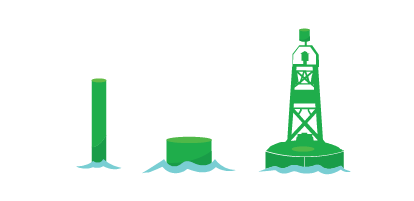 |
| Starboard | Red |  |
| Port Bifurcation | Green with one horizontal red band | 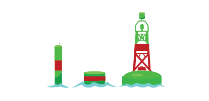 |
| Starboard Bifurcation | Red with one horizontal green band | 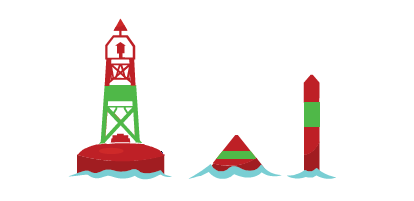 |
| North Cardinal | Black above yellow | 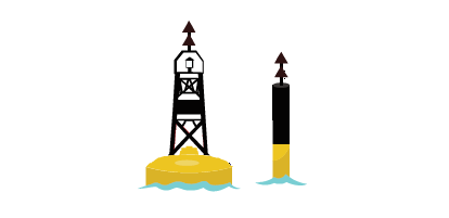 |
| East Cardinal | Black with one broad horizontal yellow band |  |
| South Cardinal | Yellow above black |  |
| West Cardinal | Yellow with one broad horizontal black band | 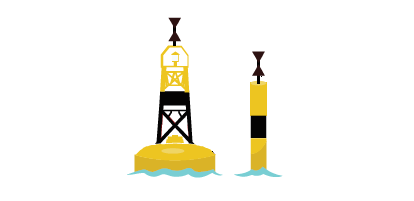 |
| Isolated Danger | Black with one broad horizontal red band |  |
| Anchorage | Yellow |  |
| Cautionary | Yellow |  |
| ODAS | Yellow | 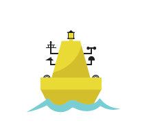 |
| Mooring | White with orange symbols | 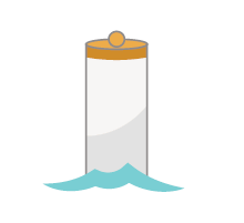 |
| Keep-out | White with orange symbols |  |
| Control | White with orange symbols | 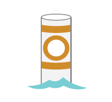 |
| Hazard | White with orange symbols | 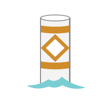 |
| Information | White with orange symbols |  |
| Swimming | White |  |
| Diving | White with red and white flag | 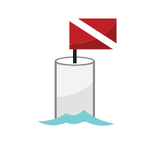 |
Buoy shape
The shape of an unlighted buoy indicates the position of the buoy with respect to the channel and thus the side on which the buoy should be passed:
A conical shape indicates that the buoy is marking the starboard (right) side of the channel or the location of a danger which must be kept on the vessel’s starboard (right) side when proceeding upstream.

A cylindrical shape (can) shape indicates that the buoy is marking the port (left) side of the channel or the location of a danger which must be kept on the vessel’s port side when proceeding upstream. Flat topped (can) buoys are also used for some applications where the shape of the buoy has no significance (for example, special buoys and cardinal buoys). In the placement of such buoys, care is taken not to convey an unsafe message in the event that the meaning of the buoy is interpreted by shape only.

A spherical shape indicates that the buoy is marking the centre of the channel or safe water and that it may be safely passed on either side although generally it should be kept on the vessel’s port (left) side when proceeding in either direction.

Topmarks
Topmarks are not used in Canada to the extent that they are used in other parts of the world because of the environmental conditions that Canadian aids to navigation must endure. The use of topmarks as an additional means of daytime buoy identification is mainly restricted to lateral, cardinal, and isolated danger buoys in ice-free conditions. Mariners are cautioned not to rely solely on topmarks as a means of buoy identification as they are susceptible to damage and may be intentionally removed during winter and ice conditions.
Where installed, the Canadian Buoyage System includes topmarks for each buoy as follows:
| Buoy type | Topmark description | Illustration |
|---|---|---|
| Fairway | Single red sphere |  |
| Port and Port Bifurcation | Single green cylinder |  |
| Starboard and Starboard Bifurcation | Single red cone, pointing upward |  |
| North Cardinal | 2 black cones, pointing upward |  |
| East Cardinal | 2 black cones, base to base |  |
| South Cardinal | 2 black cones, pointing downward |  |
| West Cardinal | 2 black cones, point to point |  |
| Isolated Danger | 2 black spheres, one above the other |  |
Tip: A way of remembering the arrangement of the conical topmarks on Cardinal Buoys is to relate the direction of the points of the cones to the location of the black portion(s) of the buoy (e.g. on an East Cardinal, the upper cone pointing up and the lower cone pointing down relate to the black colour of the upper and lower portions of the buoy).

Nighttime identification
At night, the colour and flash character of a buoy’s light indicates its function. If unlit, retroreflective material might be applied.
Buoy light flash characters
Lights of different colours are used to assist recognition of the marks in the Canadian aids to navigation system. Red and green lights for the lateral buoys, white lights for the cardinal, isolated danger, and fairway buoys and yellow lights for special buoys.
The light characteristics for all buoys in the Canadian aids to navigation system shall conform to the “Specifications for Buoy Light Characteristics” detailed in table below. The primary character shall be used in all cases except:
- when there is the need to distinguish between two identical buoys which are close to each other; or
- where emphasis is required (for example, the use of the secondary character “quick flash” to distinguish buoys marking a turn in a lateral buoy system); or
- when greater perception is required, or to improve the light’s availability in severe wave conditions.
The following are the names, abbreviations, and descriptions of the flash characters of the lights used in the Canadian Buoyage System:
Fairway
Primary: Morse Code A – Mo(A)6s

A white light in which a 0.3 second flash is followed by a 0.6 second eclipse then a 1 second long flash, repeated at a rate of 10 times per minute (every 6 seconds).
- 0.3 sec. flash; 0.6 sec. eclipse
- 1.0 sec. flash; 4.1 sec. eclipse
Secondary: Long Flash – (LFl)10s

A white light in which a flash of 2 seconds duration is repeated at a rate of 6 flashes per minute (1 long flash every 10 seconds).
- 2.0 sec. flash; 8.0 sec. eclipse
Port and starboard
Primary: Flashing – (Fl)4s

A light (red for starboard and green for port) in which the total duration of light in a period is shorter than the total duration of darkness and is regularly repeated at a rate of 15 flashes per minute (1 flash every 4 seconds).
- 0.5 sec. flash; 3.5 sec. eclipse
Secondary: Quick Flashing – (Q)1s

A light (red for starboard and green for port) in which identical flashes are repeated at the rate of 60 flashes per minute (1 flash every second).
- 0.3 sec. flash; 0.7 sec. eclipse
Bifurcation
Primary: Composite Group Flashing Fl(2+1)6s

A light (red for starboard and green for port) in which a group of 2 flashes is followed by a single flash, the whole sequence being repeated 10 times per minute (every 6 seconds).
- 0.3 sec. flash; 0.4 sec. eclipse
- 0.3 sec. flash; 1.2 sec. eclipse
- 0.3 sec. flash; 3.5 sec. eclipse
Secondary: Composite Group Flashing – Fl(2+1)10s

A light (red for starboard and green for port) in which a group of 2 flashes is followed by a single flash, the whole sequence being repeated 6 times per minute (every 10 seconds).
- 0.5 sec. flash; 0.7 sec. eclipse
- 0.5 sec. flash; 2.1 sec. eclipse
- 0.5 sec. flash; 5.7 sec. eclipse
North cardinal
Primary: Quick Flashing – (Q)1s

A white light in which identical flashes are repeated at the rate of 60 flashes per minute (1 flash every second).
- 0.3 sec. flash; 0.7 sec. eclipse
Secondary: Very Quick Flashing – (VQ).5s

A white light in which a flash is regularly repeated at a rate of 120 flashes per minute (1 flash every 0.5 second).
- 0.2 sec. flash; 0.3 sec. eclipse
East cardinal
Primary: Group Quick Flashing Q(3)10s

A white light in which a group of 3 flashes is regularly repeated at a rate of 6 times per minute (every 10 seconds).
- 0.3 sec. flash; 0.7 sec. eclipse
- 0.3 sec. flash; 0.7 sec. eclipse
- 0.3 sec. flash; 7.7 sec. eclipse
Secondary: Group Very Quick Flashing – VQ(3)5s

A very quick-flashing white light in which a group of 3 flashes is regularly repeated at a rate of 12 times per minute (every 5 seconds).
- 0.2 sec. flash; 0.3 sec. eclipse
- 0.2 sec. flash; 0.3 sec. eclipse
- 0.2 sec. flash; 3.8 sec. eclipse
South cardinal
Primary: Group Quick Flashing + Long Flash – (Q(6)+LFl)15s

A white light in which a group of 6 quick flashes is followed by a single long flash, the whole sequence being regularly repeated 4 times per minute (every 15 seconds).
- 0.3 sec. flash; 0.7 sec. eclipse
- 0.3 sec. flash; 0.7 sec. eclipse
- 0.3 sec. flash; 0.7 sec. eclipse
- 0.3 sec. flash; 0.7 sec. eclipse
- 0.3 sec. flash; 0.7 sec. eclipse
- 0.3 sec. flash; 0.7 sec. eclipse
- 2.0 sec. flash; 7.0 sec. eclipse
Secondary: Group Very Quick Flashing + Long Flash – (VQ(6)+LFl)10s

A white light in which a group of 6 very quick flashes is followed by a single long flash, the whole sequence being regularly repeated 6 times per minute (every 10 seconds).
- 0.2 sec. flash; 0.3 sec. eclipse
- 0.2 sec. flash; 0.3 sec. eclipse
- 0.2 sec. flash; 0.3 sec. eclipse
- 0.2 sec. flash; 0.3 sec. eclipse
- 0.2 sec. flash; 0.3 sec. eclipse
- 0.2 sec. flash; 0.3 sec. eclipse
- 2.0 sec. flash; 5.0 sec. eclipse
West cardinal
Primary: Group Quick Flashing – Q(9)15s

A white light in which a group of 9 flashes is regularly repeated 4 times per minute (every 15 seconds).
- 0.3 sec. flash; 0.7 sec. eclipse
- 0.3 sec. flash; 0.7 sec. eclipse
- 0.3 sec. flash; 0.7 sec. eclipse
- 0.3 sec. flash; 0.7 sec. eclipse
- 0.3 sec. flash; 0.7 sec. eclipse
- 0.3 sec. flash; 0.7 sec. eclipse
- 0.3 sec. flash; 0.7 sec. eclipse
- 0.3 sec. flash; 0.7 sec. eclipse
- 0.3 sec. flash; 6.7 sec. eclipse
Secondary: Group Very Quick Flashing – VQ(9)10s

A very quick-flashing white light in which a group of 9 flashes is regularly repeated 6 times per minute (every 10 seconds).
- 0.2 sec. flash; 0.3 sec. eclipse
- 0.2 sec. flash; 0.3 sec. eclipse
- 0.2 sec. flash; 0.3 sec. eclipse
- 0.2 sec. flash; 0.3 sec. eclipse
- 0.2 sec. flash; 0.3 sec. eclipse
- 0.2 sec. flash; 0.3 sec. eclipse
- 0.2 sec. flash; 0.3 sec. eclipse
- 0.2 sec. flash; 0.3 sec. eclipse
- 0.2 sec. flash; 5.8 sec. eclipse
Isolated danger
Primary: Group Flashing – Fl(2)5s

A white light in which a group of 2 flashes is regularly repeated 12 times per minute (every 5 seconds).
- 0.4 sec. flash; 0.6 sec. eclipse
- 0.4 sec. flash; 3.6 sec. eclipse
Secondary: Group Flashing – Fl(2)10s

A white light in which a group of 2 flashes is regularly repeated 6 times per minute (every 10 seconds).
- sec. flash; 1.0 sec. eclipse
- sec. flash; 7.0 sec. eclipse
Tip: As a way of remembering the light flash characters of the East, South and West Cardinal buoys, the number of flashes in each group for these lights is the same as the figure on the clock face in the corresponding compass direction (e.g. the 3 flashes in each group for the East cardinal corresponds to three o’clock). The long flash in the South Cardinal character ensures that there is no confusion between the 6 flashes per group of this buoy and the 9 flashes per group of the West Cardinal.

Special (except ODAS)
Flashing – (Fl)4s

A yellow light in which the duration of the flash is shorter than the duration of eclipse and is repeated at a rate of 15 flashes per minute (1 flash every 4 seconds).
- 0.5 sec. flash; 3.5 sec. eclipse
ODAS (Ocean Data Acquisition System)
Group Flashing – Fl(5)Y 20s

A yellow light in which a group of 5 flashes is regularly repeated 3 times per minute (every 20 seconds).
- 0.5 sec. flash; 1.5 sec. eclipse
- 0.5 sec. flash; 1.5 sec. eclipse
- 0.5 sec. flash; 1.5 sec. eclipse
- 0.5 sec. flash; 1.5 sec. eclipse
- 0.5 sec. flash; 11.5 sec. eclipse
Buoy light colour
Colours of the buoy lights used in the Canadian Buoyage System
| Buoy type | Light colour |
|---|---|
| Port and Port Bifurcation |  |
| Starboard and Starboard Bifurcation |  |
| Fairway, Isolated Danger, and all Cardinals |  |
| All Special buoys |  |
Retroreflective material
Retroreflective material is applied to unlighted buoys to aid in their nighttime identification with a watertight flashlight or other light source and to lighted buoys as a back up to the light. For all buoys other than special buoys the colour of the retroreflective material is the same as that of the light which would be appropriate for each buoy.
In cases where a special buoy is equipped with retroreflective material for use with number or letter plates/backgrounds, the colour of that material will be yellow. Additionally, where a buoy exhibits an orange symbol (e.g. Hazard buoy), orange retroreflective material may be added to enhance visibility of the symbol.
Note: Swimming and diving buoys, which are white in colour, will use yellow retroreflective material.
Other characteristics
Buoy numbering
Only starboard and port hand buoys are numbered; starboard hand buoys with even numbers and port hand buoys with odd numbers. Buoy numbers increase in the upstream direction and are kept in approximate sequence on both sides of the channel by omitting numbers where required. Buoy numbers are usually preceded by one or two letters to facilitate channel identification.
All other types of buoys are identified by letters only. All types of buoys may be identified by a name in addition to a number or letter identification. Private buoys are not numbered or lettered as they are not government-owned. Instead, they display the letters “PRIV” and other information required by the Private Buoy Regulations.
Audible signals
Any of the buoy types in the Canadian Buoyage System may be fitted with a bell or a whistle that is activated by the motion of the buoy in the water. The use of such buoys is generally restricted to coastal waters where there is sufficient buoy motion to activate the sound device and where there is a requirement for an audible signal to enable location of the buoy under low visibility conditions.
Note: With improved electronic navigation systems and advancing technology, traditional audible aids are no longer considered effective aids to navigation.
Radar reflectors
Many buoys are fitted with radar reflectors to improve their visibility on the radar screen.
Radar beacons (RACONS)
When precise identification of a buoy is considered essential, the buoy may be fitted with a radar beacon (RACON). Part 2 of the Radio Aids to Marine Navigation publication provides a complete list of RACONS with information such as name and location, range, arc, and identifier (morse code). The List of Lights, Buoys and Fog Signals publication also provides some information on the RACON.
Marking of new dangers
New dangers such as a shipwreck or the discovery of an uncharted shoal or rock can occur suddenly and unexpectedly in waters which mariners have come to regard as safe. The Canadian buoyage system makes the following special provisions for these hazards:
- Primary choice for marking a new danger is the Isolated Danger Aid moored on or installed above the danger. Lateral buoys, cardinal aids, or cautionary buoys can also be used.
- One or more of the aids marking the new danger may be duplicated, the duplicate being identical to its partner in all respects.
- In general, any lighted lateral or cardinal aid used to mark a new danger will display the most rapid flash character available for that aid.
- A new danger may be marked by a RACON coded Morse “D” ( – ● ● ).
- Special measures taken to mark a new danger may be discontinued when information concerning the new danger has been sufficiently promulgated.
Fixed aids to navigation
General
The characteristics of fixed aids are for identification purposes. They consist of the light colour, flash character, and the colour and shape of the structure, as advertised in the List of Lights, Buoys and Fog Signals publication.
Lighted fixed aids
General
Lighted fixed aids are structures equipped with a light and located at prominent sites to assist the mariner to fix their position. They may be at or near shorelines or on built-up, man-made piers in or near waterways. The structure and colour(s) of lighted fixed aids are often selected for maximum visibility and ease of identification and may or may not have lateral significance.
Types
The types and shapes of fixed, lighted structures used in Canada are varied. They may have vertical or tapering sides, may be circular, square, polygonal, or octagonal in shape, and may be constructed of wood, masonry, concrete, metal, or fibreglass. They may be slender cylindrical structures such as pipes or poles or open skeleton towers.
Major lighted aids are coastal landfall lights that have distinctive characteristics to assist the mariner in determining their exact location.
Minor lighted aids are fixed marks which indicate position or warn of dangers. Typically, minor lighted aids which display a single red, green, or black band, or a daymark, mark lateral significance. Minor lighted aids which display double red bands provide for secondary landfall. Where these secondary landfall aids are also used to define lateral significance, a lateral daymark (e.g. a green square – port) will be displayed between the two red bands.
Note: See the Canadian Aids to Navigation System quick reference guide (vertical) (PDF, 1.94 MB, available in PDF format only) or video for further explanations of these types.
Cardinal Aids indicate the location of the safest or deepest water by reference to the cardinal points of the compass. There are four cardinal aids: North, East, South, and West. Please refer to Cardinal Buoys for characteristics as they are similar to cardinal buoys characteristics.
Isolated Danger Aids may be in the form of either buoys or beacons. However, their predominant use is in the form of buoys in the Canadian system. They are installed above an isolated danger which has navigable water all around it. It is black with one broad red horizontal band and displays identification letter(s). For more characteristics, please refer to Isolated danger buoys.
Lateral significance
When proceeding upstream, fixed aids displaying a red triangular symbol in the centre of the daymark or a single red band at the top of the tower must be kept on the vessel’s starboard (right) hand side. Fixed aids displaying a black or green square symbol in the centre of the daymark or a single green or black band at the top of the tower must be kept on the vessel’s port (left) hand side.
Fixed aids displaying a red diamond outline symbol in the centre of the daymark indicate a division in the channel and may be passed on either side. However, when proceeding upstream, a red triangle in the centre of the red diamond indicates that the preferred route is to the left (i.e. the aid should be kept on the vessel’s starboard [right] side). Similarly, a black or green square in the centre of the red diamond indicates that the preferred route is to the right (i.e. the aid should be kept on the vessel’s port [left] side).
Light characteristics
The following are the names, abbreviations (as they appear on nautical charts), and descriptions of the basic types of light flash characters for Canadian light stations:
Fixed (F)
A light which appears continuously

Isophase (Iso)
A light in which the alternations of light and darkness are of equal length. E.g. Iso

Flashing (Fl)
A light in which the flash is clearly shorter than the duration of darkness (eclipse) and in which the flashes of light are all of equal duration.
Single-flashing light e.g. Fl

Long-flashing light e.g. LFl

Group-flashing light e.g. Fl(2)

Composite group-flashing light e.g. Fl(2 + 1)

Occulting (Oc)
A light in which the flash is clearly longer than the duration of darkness (eclipse) and in which the intervals of darkness are all of equal duration.
Single occulting light e.g. Oc

Group-occulting light e.g. Oc(2)

Composite group-occulting light e.g. Oc(2+1)

Emergency Backup (FI(6)15s)
A light in which a group of 6 flashes is regularly repeated at a rate of 4 sets per minute (every 15 seconds)
Quick (Q)
A light in which flashes are repeated at a rate of not less than 50 flashes per minutes but less than 80 flashes per minute
Continuous quick-flashing light e.g. Q

Group quick-flashing light e.g. Q(3)

Very Quick (VQ)
A very quick-flashing light in which a flash is regularly repeated at a rate of not less than 80 flashes per minute but less than 159 flashes per minute (usually either 100 or 120 flashes per minute) e.g. VQ

e.g. VQ(6)+LFl

Morse Code (Mo(A))
A light in which flashes of light of two clearly different durations are grouped to represent a character or characters in the Morse Code.
e.g. Mo(A)

The duration of flash and darkness of each light may vary and are advertised in the appropriate List of Lights, Buoys and Fog Signals publication. Mariners are advised that there may be more than one light flash character displayed by a light station (e.g. a high intensity flashing light may be superimposed on a fixed light) and thus, the List of Lights, Buoys and Fog Signals publication should be consulted to ensure proper identification.
Light colours
The choice of light colour for fixed aids is dependent on individual site conditions (e.g. presence of background light) and the luminous range of the light colour in relation to those conditions. As a result, no set rules exist for such lights and mariners should always consult the chart to determine the function of each light.
There are, however, a few general guidelines which may be followed:
- Major coastal landfall lights are normally white,
- Green or red lights are normally used to denote port and starboard lateral significance, and
- Yellow lights may be used to define areas where caution should be exercised.
Any white, green, or red light may be changed to yellow without warning in situations where a new hazard necessitates the exercise of caution. An example of such a situation is where silting results in a reduction of water depths restricting safe navigation to only small vessels.
Daymarks and daybeacons
A daybeacon is a structure equipped with a daymark, used primarily to assist the mariner during daylight hours where night navigation is negligible or where it is not practicable to operate a light. Also referred to as unlighted fixed aids. Daymarks can also be found on minor lighted aids.
Colour, shape, and possibly a number are the characteristics that identify the significance of a daymark to the mariner. Retroreflective and/or fluorescent material is applied to the daymark to improve their visibility and identification at night with the aid of a searchlight.
A daymark is positioned facing the direction of the mariner’s approach. Where it is necessary to display daymarks facing two directions, the two daymarks shall be mounted back to back, or in such a fashion as to not distort the shape of the daymark or appearance of the daybeacon from any direction of approach.
Port Hand daybeacon
A port hand daybeacon has a daymark that is square with a green fluorescent or black square centre on a white background and with a green retroreflective border. It may display an odd number made of white retroreflective material. When proceeding upstream, a port hand daybeacon must be kept on the vessel’s port (left) side.
Starboard hand daybeacon
A starboard hand daybeacon has a daymark that is triangular, with a red fluorescent triangular centre on a white background and with a red retroreflective border. It may display an even number made of white retroreflective material. When proceeding upstream, a starboard hand daybeacon must be kept on the vessel’s starboard (right) side.

Bifurcation daybeacon
A bifurcation daybeacon has a daymark that is a diamond shape and marks a point where the channel divides.
It may be passed on either side.
- When proceeding in the upstream direction, a bifurcation daybeacon displaying a daymark with a green retroreflective square on a white diamond with a red fluorescent border indicates that the preferred route is to the right. When proceeding downstream, the preferred route is to the left.

- When proceeding in the upstream direction, a bifurcation daybeacon displaying a daymark with a red retroreflective triangle on a white diamond with a red fluorescent border indicates that the preferred route is to the left. When proceeding downstream, the preferred route is to the right.

No anchorage
A no-anchorage daybeacon has a daymark that is square with a black anchor symbol centred on a white background with a red fluorescent diagonal stripe superimposed across it. Do not anchor within the zone indicated on the chart. The area may contain submerged pipelines, power cables, etc.

Ranges
A range consists of two structures, each equipped with a trapezoid-shaped fixed daymark, the front daymark resembling the lower half of an hourglass and the rear daymark resembling the top half of an hourglass. These daymarks have a red, white, or black strip running vertically, superimposed on a red, white, or black background. Ranges may or may not be lighted. If lighted, the colours of the range daymarks as well as the colours and characters of the lights are advertised in the appropriate List of Lights, Buoys and Fog Signals publication. In some cases, 24-hour range lights may be provided without the addition of daymarks.

Audible aids
General
Audible aids are sound-producing aids such as bell buoys, whistle buoys, and fog horns, that warn mariners of dangers when visual aids are obscured by weather conditions.
Note: With improved electronic navigation systems and advancing technology, traditional audible aids are no longer considered effective aids to navigation.
Operation
Audible aids are normally operated manuallyFootnote 1 or automatically by wave action and when visibility is reduced to less than two nautical miles. Although they are relied upon by specific users when the availability target for visibility cannot be met by the designed system, they may only be used as a hazard warning since they are not considered effective aids to navigation.
If a need to augment an aid to navigation system with sound signals is determined, the propagation of sound in the area must be considered to determine the best audible aid to be used.
Characteristics
The mariner can identify audible aids by their characteristics. When advertised in the List of Lights, Buoys and Fog Signals publication, these characteristics and directional positioning of the aid will be included, as shown in the example below.
Audible aids characteristics example
Figure 2: Example of audible aids characteristics from LL Book

Text description for Figure 2: Example of audible aids characteristics from LL Book
- No.: 6
- International reference number: H440
- Name: Cape Pine
- Position: On the cape
- Latitude N.: 46 37 01.1
- Longitude W.: 053 31 53.1
- Light Characteristics:
- FI
- W
- 5s
- Focal Height in m. above water: 95.7
- Nominal Range: 16
- Description: Cylindrical tower, red and white horizontal bands.
- Height in meters above ground: 18.4
- Remarks: Flash 0.5 s; eclipse 4.5 s. Year round.
- Fog Signals:
- Horn - Blast 4 s; sil. 56 s. Horn points 159°.
- Chart – 4842
Sector lights
General
A sector light consists of a single light whose total luminous beam is normally divided into sectors of different colours to provide a warning or a leading line to mariners. Occasionally, a sector light will display a single colour light beam with a restricted angle of coverage (see illustration in the Canadian Aids to Navigation System quick reference guide (vertical) (PDF, 1.94 MB, available in PDF format only). The colour(s) and boundaries of these sectors are indicated in the appropriate List of Lights, Buoys and Fog Signals publication and on nautical charts. Note that a white sector indicates safe passage.
Sector light types
To mark the presence of obstacles
When only a red sector is used within a white luminous beam, the red sector marks obstructions such as shoals.

As a leading line
A combination of red, white, and green sectors in a luminous beam is used to provide a leading line to mariners. When proceeding upstream, the red sector indicates the starboard hand limit, the white sector indicates the recommended course, and the green sector indicates the port hand limit.

Sector lights with oscillating boundaries
Some sector lights may be equipped with an oscillating boundary feature. This creates additional “boundary sectors” between solid sectors. Within these boundary sectors the rhythm of the alternating light colours will give the observer a visual indication of their position.

Application
The most common application of this feature is the three colour (red/white/green) leading-line sector light, however, the mariner should consult the chart and other publications for the proper interpretation and usage of each light. Regardless of the orientation of the colours, the chart symbol (abbreviation) for a three colour sector light is always RWG.
For example, when proceeding upstream and crossing a three-colour oscillating boundary sector light marking an upstream course from left to right, the mariner would see, in order:
- G
- Solid Green
- AIGW
- Green and white lights alternating every three (3) seconds. The duration of white light is short when entering the sector limits becoming progressively longer as the navigator crosses towards the solid white sector.
- W
- Solid white
- AIRW
- Red and white lights alternating every three (3) seconds. The duration of the red light is short when entering the sector limits becoming progressively longer as the navigator crosses towards the solid red sector.
- R
- Solid Red
Electronic aids to navigation
Automatic Identification System aids to navigation (AIS AtoN)
An Automatic Identification System aid to navigation (AIS AtoN) is a digital aid to navigation that is broadcast by an authorized service provider using the AIS Message 21 (Aids-to-navigation report) and may be displayed on properly configured shipborne and shore-based navigation equipment such as the Electronic Chart Display Information System (ECDIS), radar, or an Integrated Navigation System (INS). It is used to supplement existing aids to navigation and aid systems, in situations where physical aid placement is impractical, or in special circumstances, such as seasonal slowdown areas. AIS AtoN provide a positive and all-weather means of identification to mariners.
The following types of AIS AtoN may be used in Canada:
- Physical AIS AtoN is based on a signal transmitted from an aid to navigation that physically exists;
- Virtual AIS AtoN is based on a signal transmitted from a source other than a physical AtoN, indicating an aid that is only displayed on electronic navigation equipment and does not physically exist.
- Synthetic AIS AtoN exist as a hybrid of physical and virtual types; they are transmitted from AIS stations located at a distance from a physical AtoN. The Monitored variant involves a communications link between the aid and the station, thereby confirming its position, while the Predicted variant does not.
Every AIS AtoN is assigned a Maritime Mobile Service Identity (MMSI) number.
A diamond-shaped symbol is used to represent an AIS AtoN signal on electronic navigation displays that interface with the AIS. Real and Synthetic types are represented by solid lines, while Virtual aids are represented by dotted lines. Further information about each aid appears when interacting with them through electronic navigation equipment. See the figures below for examples.
Figure 3: Diamond shaped symbols used to represent an AIS AtoN signal

Text description for Figure 3: Diamond shaped symbols used to represent an AIS AtoN signal
The basic shape of a real or synthetic AIS AtoN is a diamond, outline in a thick solid line, with a plus sign in the middle.
The basic shape of a virtual AIS AtoN is a diamond, outline in a thick dashed line with a plus sign in the middle.
Examples of real or synthetic and virtual AIS AtoN have the basic shapes with a smaller shape, outlined in a thin, solid line, placed on top of the diamond. The names of the examples and the corresponding smaller shape are as follows:
- Starboard hand mark: triangle
- Port hand mark: square
- North cardinal mark: two stacked triangles, both pointing upward
- East cardinal mark: two stacked triangles, vertically pointing away from each other
- South cardinal mark: two stacked triangles, both pointing downward
- West cardinal mark: two stacked triangles, vertically pointing toward each other
- Isolated danger mark: two stacked circles
- Safe water mark: circle
- Special mark: X
Radar Reflectors and Radar Beacons (RACONS)
General
The detection of a radar target is essentially dependent on the level of energy reflected back to the radar receiver from the target. When an aid to navigation gives a poor radar echo, equipment may be fitted to the aid to give an enhanced echo on a radar display. There are two main methods of producing a radar-enhanced target. The first is by using a passive device such as a radar reflector to enlarge the apparent echoing area of the target and the second is by the use of a radar beacon (RACON), which is an active device. RACONS can also be used to avoid confusion between radar targets that may look similar, because they produce an easily identifiable coded trace on the radar display. This feature makes RACONS effective in the marking of important or radar-inconspicuous features or structures such as gently sloping shorelines and bridge piers.
Radar Reflectors
Certain fixed shore aids and most buoys are designed or equipped to enhance the aids’ ability to reflect radar signals. Radar reflectors may also be established as independent aids to navigation. Independent radar reflectors are symbolized on charts and those established on lighted aids are advertised in the appropriate List of Lights, Buoys and Fog Signals publication.
Radar Beacons (RACONs)
A RACON is comprised of three main components: a receiver, a transmitter, and an antenna common to both the receiver and the transmitter. A radar within the range of the RACON interrogates the RACON each time the radar antenna points towards the RACON. The RACON receiver detects the radar interrogating the signal and triggers the RACON transmitter. The transmitter may reply with a single pulse for each trigger but normally the response consists of a series of coded pulses (Morse code) for RACON identification. After triggering, a finite time must be allowed for the RACON to respond. This results in a transmission that is delayed in time and range with respect to the passive echo of the structure on which the RACON is mounted. The delay is generally equivalent to a range of less than 100 metres and, therefore, can often be disregarded at ranges greater than a few nautical miles. It is at short ranges that this error is significant. Normally, the station structure echo is visible and its range can be measured to full radar accuracy.
Radar operators may notice some broadening or spoking of a RACON's presentation on their vessel’s close approach. This effect can be minimized by adjusting the IF gain or sweep gain control of the radar (other targets will also be reduced in intensity).
Cautionary Note
Care must be exercised in the use of the radar display controls. The RACON's presentation can be virtually eliminated by operation of the Fast Time Constant controls of the radar. The RACON’s replies may also be suppressed by the operation of the automatic video processor which is found in an increasing number of marine radars.
Frequency Agile RACONS
These RACONS are the most commonly used RACONS in Canadian waters. The Frequency Agile RACON measures the frequency and signal strength of the interrogating radar pulse, then tunes its transmitter to that frequency before responding. This RACON provides service for X band marine radars and some installations also provide service for the marine radar band of 2920 to 3100 MHz (10 cm or S band). While it is possible for a response to be displayed on each antenna scan of every radar within range, in actual practice, these RACONS are programmed to turn off for a pre-selected period at regular intervals to prevent the masking of other echoes.
The locations, codes, and operating frequencies (X, S or X and S) of RACONS are published in Notices to Mariners and listed in the appropriate marine publications, i.e. Radio Aids to Marine Navigation, Sailing Directions, and List of Lights, Buoys and Fog Signals. The Canadian Hydrographic Service charts display the Morse code of RACONS only in areas where more than one RACON can be interrogated simultaneously.
Global Navigation Satellite System (GNSS)
System description
The Global Navigation Satellite System is a term used to describe the collection of satellite systems providing signals from space with position, navigation, and timing (PNT) information to GNSS receivers and determining their location. The first GNSS ever developed is the United States GPS system. Other GNSS such as the Russian Glonass, the European Galileo and the Chinese BeiDou systems are also operational or in pre-operational mode with the objective to offer similar worldwide PNT services to users anywhere, at any time, and in any weather.
All GNSS orbit in the Medium Earth Orbit (MEO) at an altitude of over 20,000 km from the Earth surface which is recognized to be optimal for global positioning, navigation, and timing application. GNSS signals usually broadcast an exclusive military signal and/or restricted signal and other signals for civilian use. The civil GNSS signals include an open service signal that is freely available to any user with a compatible receiving device.
Users operating a single frequency receiver under normal conditions with at least four satellites in line of sight above a minimum elevation of 5 degrees have the capability to meet the IMO maritime requirement of 10 m horizontal position accuracy.
Performance Standard (PS)
The minimum performance levels of each GNSS are detailed in their respective performance standard document. This document specifies the performance metrics such as accuracy, integrity, availability, continuity, and health of the satellites forming the constellation and much more. The latest performance standard documents of each operational GNSS constellation are available on the internet. The government or entity responsible for a specific GNSS constellation commit to meeting and exceeding the levels of services published in their document.
| Constellation | Horizontal Position accuracy Std (95%) | Constraints | Document version |
|---|---|---|---|
| GPS | 8 m |
|
SPS PS éd. 5, 2020 |
| Glonass | ≤ 7,8 m | OS PS v2.2, 2020 | |
| Galileo | ≤ 7 m | OS SDD v1.2, 2021 | |
| BeiDou | ≤ 9 m | OS PS v3.0, 2021 |
Legend:
- SPS PS: Standard Positioning Service Performance Standard
- OS PS: Open Service Performance Standard
- OS SDD: Open Service – Service Definition Document
GNSS Augmentation System
GNSS augmentation systems are systems that complement the core GNSS to improve accuracy, availability, continuity, and integrity of PNT applications. GNSS augmentation systems are delineated into two distinct groups: satellite-based augmentation systems (SBAS) and ground-based augmentation systems (GBAS) where the augmentation information comes from satellites and from ground stations respectively.
The Wide-Area Augmentation System (WAAS) is a satellite-based augmentation system (SBAS) that complements GNSS to improve PNT information over North America. The WAAS system was developed by the US Federal Aviation Administration (FAA) and commissioned in 2003 to be utilized for air navigation safety-critical tasks. A 2019 study conducted by Serco, on behalf of CCG, concluded that WAAS is a viable solution for maritime navigation in Canadian waters.
The WAAS system consists of three geostationary (GEO) satellites and multiple referenced ground stations, including four WAAS reference stations located in Canada. These GEO satellites broadcast GPS correction and integrity information back to WAAS-enabled GPS receivers that use the satellite position and clock data corrections to refine their computed position thereby improving accuracy.
Users can expect to receive up to five times better precision using a SBAS-enabled receiver compared to a GPS-only capable receiver. Typical coverage limit of WAAS in the Arctic is assumed to be about 72 degrees latitude North.
WAAS Performance Standard
The FAA commits to meet the performance levels specified in the GPS WAAS Performance Standard for the provision of WAAS service. The 2019 WAAS study demonstrated that an accuracy of less than 2 metres is possible when WAAS corrections are applied.
Figure 4: WAAS Position Accuracy. Source: (ION GNSS+2019, An Evaluation of WAAS 2020+ to Meet Maritime Navigation Requirements in Canadian Waters, G. Johnson, G. Dhungana and J.Delisle https://www.ion.org/publications/abstract.cfm?articleID=16942)

Text description for Figure 4: WAAS Position Accuracy
This map of Canada shows in shades of blue to green that the typical WAAS position accuracy error is less than 3 meters from coast to coast to coast. The center including the Great Lakes areas and Hudson Bay show a position error below 2.2 meters.
Ten stations including four on the west coast (Prince Rupert, Kitimat, Port Hardy and Vancouver), four on the East coast (St. John’s, St. John, Saguenay and Halifax) and two in the Arctic collected WAAS data for the campaign measurement (Iqaluit and Inuvik).
Related publications
- Safe Boating Guide (PDF, 5.6 MB, available in PDF format only)
- Transport Canada publishes this resource to make sure that you know the regulations that apply to boating and that you learn more about safe and responsible boating practices.
- This publication is available on Transport Canada’s website under Marine transportation.
- An Owner’s Guide to Private Buoys (PDF, 987 KB, available in PDF format only)
- This guide will help private buoy owners to understand and apply Canada’s laws and standards, and inform them of their responsibilities when placing a private buoy.
- Radio Aids to Marine Navigation
- This annual publication provides information concerning Marine Communications and Traffic Services (MCTS) Centres, consolidated information concerning Vessel Traffic Services (VTS), and Environment and Climate Change Canada (ECCC)’s Marine and Ice Warning and Forecast Programs. In addition, it lists the location and characteristics of marine radio aids to navigation, i.e. RACONs.
- List of Lights, Buoys and Fog Signals
- This publication contains information on the characteristics and positions of shore lights, lighted buoys, and fog signals in various regions. It is available for download and updates at the NOTMAR website in English and French for the following regions:
- Newfoundland and Labrador Coast
- Atlantic Coast (includes Gulf & St. Lawrence River to Montréal)
- Inland Waters (West of Montréal, East of British Columbia)
- Pacific Coast (includes Coastal waters, Rivers & Lakes of British Columbia)
- This publication contains information on the characteristics and positions of shore lights, lighted buoys, and fog signals in various regions. It is available for download and updates at the NOTMAR website in English and French for the following regions:
- Notices to Mariners Website
- The Canadian Coast Guard’s Notices to Mariners (NOTMAR) website is a free 24-hour service providing mariners with safety advisories and corrections (current and archived) to charts and nautical publications. It is the continuous means employed by the Canadian Coast Guard to promulgate information required by the master, pilot, or person in charge of the navigation of a vessel, as well as other interested parties, to correct charts, Lists of Lights, Buoys and Fog Signals, and other associated publications carried on board ships in Canadian waters. Mariners are also informed of navigational hazards such as shoals and wrecks, as well as the enactment of regulations and the establishment of procedures governing vessel entry into and transit in Canadian waters.
- The services offered through NOTMAR are as follows:
- Monthly Edition of Notices to Mariners (Eastern and Western)
- Annual Edition of Notices to Mariners (national publication)
- Lists of Lights, Buoys and Fog Signals (4 volumes: Newfoundland and Labrador Coast, Atlantic Coast, Inland Waters, and Pacific Coast)
- Monthly Summary of Temporary and Preliminary Notices
- Archived notices dating back to 1998
- A quick search on chart correction notices, updated weekly
- Email notification service to be notified when charts of interest are updated and the Monthly Edition of Notices to Mariners is published
- Annual Edition of Notices to Mariners
- Published annually at the beginning of each year, it contains information on a wide variety of subjects of concern to the mariner. Subjects covered include:
- aids to navigation
- military exercise areas
- marine regulations
- charts and publications
- marine occurrences and pollution
- marine safety
- search and rescue
- Published annually at the beginning of each year, it contains information on a wide variety of subjects of concern to the mariner. Subjects covered include:
- Canadian Tide and Current Tables
- This publication contains daily tide predictions for all Canadian reference ports along with tidal differences for secondary ports. Daily current predictions are also included for selected stations. Tide and Current Tables are published in 7 volumes and are listed in the Catalogues of Nautical Charts.
- Volume 1 (PDF, 2.7 MB, available in PDF format only) – Atlantic Coast and Bay of Fundy
- Volume 2 (PDF, 3.5 MB, available in PDF format only) – Gulf of St. Lawrence
- Volume 3 (PDF, 2.6 MB, available in PDF format only) – St. Lawrence River and Saguenay Fiord
- Volume 4 (PDF, 2.7 MB, available in PDF format only) – Arctic and Hudson Bay
- Volume 5 (PDF, 10.1 MB, available in PDF format only) – Juan de Fuca Strait and Strait of Georgia
- Volume 6 (PDF, 10 MB, available in PDF format only) – Discovery Passage and West Coast of Vancouver Island
- Volume 7 (PDF, 9.2 MB, available in PDF format only) – Queen Charlotte Sound to Dixon Entrance
- This publication contains daily tide predictions for all Canadian reference ports along with tidal differences for secondary ports. Daily current predictions are also included for selected stations. Tide and Current Tables are published in 7 volumes and are listed in the Catalogues of Nautical Charts.
Canadian Coast Guard Aids to Navigation offices
Central administration
Canadian Coast Guard
National Manager, Aids to Navigation
222 Nepean Street
Ottawa ON K2P 0B8
Email: dfo.ccgaidstonavigationconsult-gccconsultaidealanavigation.mpo@dfo-mpo.gc.ca
Atlantic Region
CCG Regional Headquarters
P.O. Box 5667
St. John’s, NL A1C 5X1
Regional Operations Center
1-709-772-6220
Email: dfo.ccgatlroc-coratlgcc.mpo@dfo-mpo.gc.ca
AtoN Operations Supervisor
175 McIlveen Drive
Saint John, NB
E2L 4B3
1-506-636-4708 (Bilingual Service)
Email: dfo.ccgatlaidstonavigation-aidesalanavigationatlgcc.mpo@dfo-mpo.gc.ca
Navigational Warnings
“N” Series NAVWARNs
1-709-695-2168 (Bilingual Service) (Holidays & Nights)
1-800-563-9089 (Bilingual Service) (Holidays & Nights)
Email: MCTS Port aux Basques navwarn.mctsportauxbasques@innav.gc.ca
Navigational Warnings
“M” Series NAVWARNs
1-902-564-7751 (Bilingual Service) (Holidays & Nights)
1-800-686-8676 (Bilingual Service) (Holidays & Nights) (Toll Free)
Email: MCTS Sydney navwarn.mctssydney@innav.gc.ca
Arctic Region
Yellowknife, NT
Superintendant, Navigational Program
Canadian Coast Guard
5120 49th Street,
3rd Floor
Yellowknife, NT X1A 1P8
867-444-0109 (Bilingual Service)
Email: dfo.ccgarcticAidsnavigation-aidesalanavigationarctiquegcc.mpo@dfo-mpo.gc.ca
Navigational Warnings
“A” Series NAVWARNs
1-867-979-5269 (Bilingual Service) (Holidays & Nights)
Email: navwarn.mctsiqaluit@innav.gc.ca
Central Region
Québec, Qc
Superintendent, Aids to Navigation
1550, Avenue D’Estimauville
Québec, QC G1J 5E9
1-418-648-3574 (Bilingual Service)
Email: dfo.rccgcentralnpansioffice-bureaudusianpncentregccr.mpo@dfo-mpo.gc.ca
Navigational Warnings
“Q” and “C” Series NAVWARNs
1-613-925-0666 (Bilingual Service) (Holidays & Nights)
Email: navwarn.mctsprescott@innav.gc.ca
St. Lawrence Sector
Québec, QC
Supervisor Aids to Navigation
1550, Avenue D’Estimauville
Québec, QC G1J 5E9
1-418-649-6999 (Bilingual Service)
Email: aides-nav-quebec.xlau@dfo-mpo.gc.ca
Great Lakes Sector
Sarnia, ON
Supervisor Aids to Navigation
520 Exmouth Street
Sarnia, ON N7T 8D1
1-519-383-1871 (English only service)
Email: dfo.ccgcentralatongreatlakes-grandslacsaalancentregcc.mpo@dfo-mpo.gc.ca
Western Region
Victoria, BC
Superintendent
Aids to Navigation and Waterways
25 Huron Street
Victoria, BC V8V 4V9
1-250-480-2602 (English only service)
1-800-667-2179 (Toll Free)
Email: ccgbasevicmns@pac.dfo-mpo.gc.ca
Navigational Warnings
“P” Series NAVWARNs
1-250-627-3070 (Holidays & Nights)
Email: navwarn.mctsprincerupert@innav.gc.ca
IALA / AISM Maritime Buoyage System: Buoyage regions A and B
Figure 5: IALA / AISM Maritime Buoyage System

Text description for Figure 5: IALA / AISM Maritime Buoyage System
The International Association of Marine Aids to Navigation and Lighthouse Authorities (IALA) Maritime Buoyage System is divided into two regions. Region A includes part of the Atlantic Ocean, Africa, Europe, Asia, Middle East, Australia, and part of the Pacific Ocean. Region A land marked in yellow. Region B includes North and South America. Region B land marked in blue. This information is believed to be correct at time of issue by IALA (March 2010). It is not to be used for navigation and users should consult current nautical publications for latest status.
- Date modified: